Can The Seas Survive Us?
at The Sainsbury Centre for Visual Arts
This March, the Sainsbury Centre will open their latest programme, Can the Seas Survive Us?, a series of three concurrent exhibitions examining the choices shaping our future due to climate change, while emphasising the vital importance of the oceans and the life beneath the waves for the viability of our shared future.
The Sainsbury Centre continues its innovative series of investigative exhibitions with a new programme that charts a course through the story of the world’s oceans and the precarious future they may be heading towards.
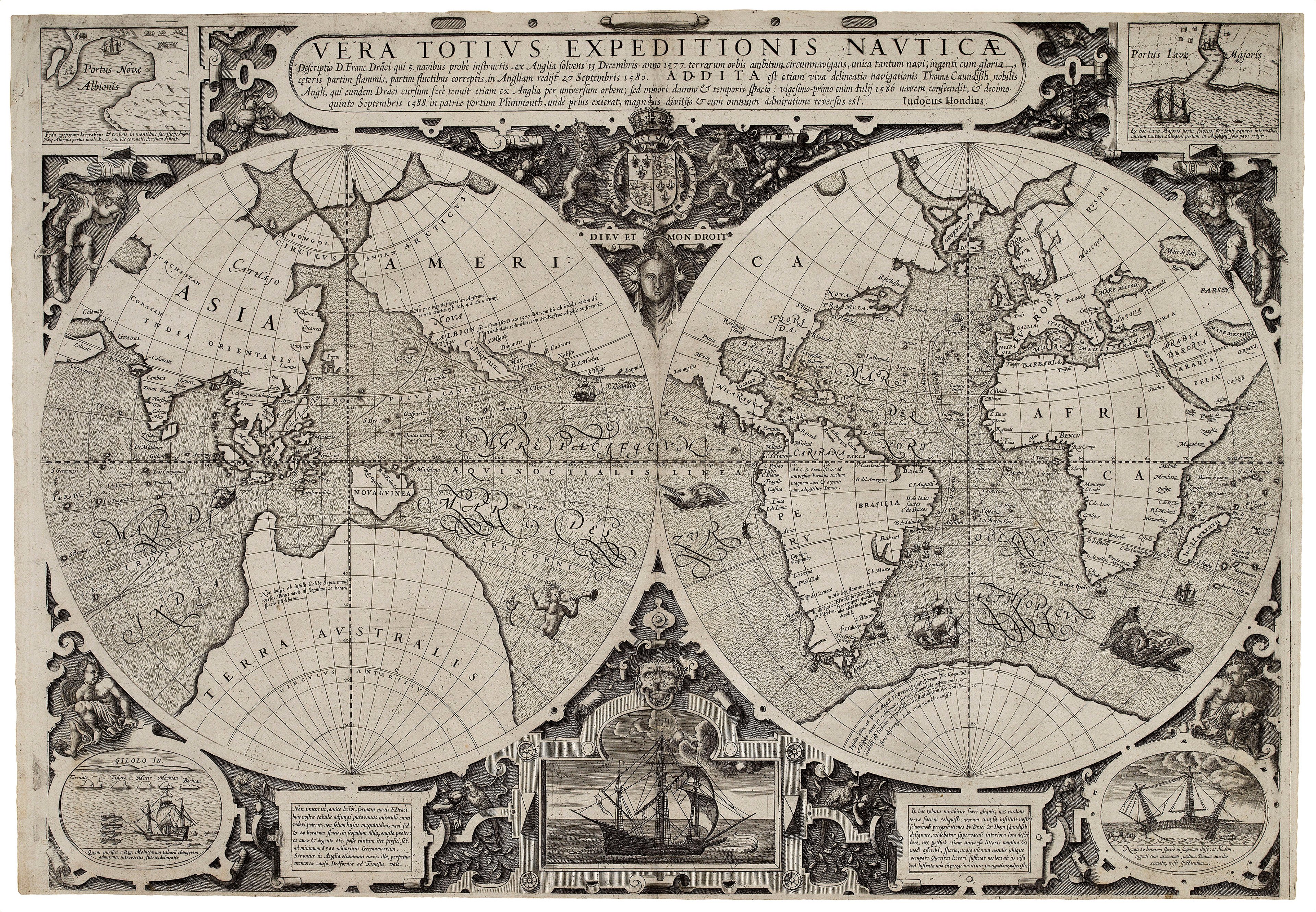
The Sunderland Collection is very proud to be making its first institutional loan to the Sainsbury Centre for its exhibition "A World of Water" - on now until 3 August 2025. Visit now to view Waghenaer's Mariner's Mirror, Munster's Geographia, Dudley's Dell'Arcano del Mare, the "Drake Map", and other treasures to accompany the body of work and to add a historical perspective of humans' relationship with the seas.
Find out more about each of the loaned works below;

Sebastian Münster’s 1540 edition of Claudius Ptolemy's 'Geographia' established the convention that a universal atlas should include world and continental maps and was the first printed work to render latitude and longitude in their now-standard form. It also includes the first printed map of the Western Hemisphere, the first set of maps of the four continents, and the first printed map to name the Pacific Ocean.

This stunningly illustrated work is the earliest European printed sea atlas. The Mariner's Mirror was created in 1586 by Lucas Janszoon Waghenaer who brought together for the first time detailed information from manuscripts, rutters, and ships’ logs, which he systematised and illustrated with informative and exquisitely engraved sea charts. Waghenaer standardised and updated the pictorial silhouettes traditionally used by pilots, drew compass roses and lines of navigational direction, and included soundings to help navigators.

This rare broadsheet map was produced by the master engraver Jodocus Hondius between 1589 and 1595. It celebrates the voyages of Sir Francis Drake and Thomas Cavendish, the first Englishmen (and only the second and fourth men) to circumnavigate the globe. These voyages were very significant because they directly challenged Spain's supremacy over the New World.

This magnificent and very scarce sea atlas by Robert Dudley is titled ‘Dell’Arcano del Mare’ (‘The Secrets of the Sea’) was revolutionary in its time: it was the first sea atlas of the world; the first to use Gerard Mercator’s projection; the earliest to show magnetic deviation; the first to show currents and prevailing winds; and the first to expound the advantages of ‘Great Circle Sailing’ (i.e. the shortest distance between two points on a globe).

Andreas Cellarius’ stunning 'Harmonia Macrocosmica' (1660), was the only celestial atlas published during the Golden Age of Dutch Cartography, and probably the finest celestial atlas ever realized. The atlas features twenty-one sumptuous Baroque-style charts that majestically represent the three competing astronomical models of the day: the Ptolemaic, Tychonic, and the Copernican.

Dutch Admiralty Copy of the ‘Zee-atlas’ (1675) by Pieter Goos, one of the best-known maritime booksellers of Amsterdam. His elegant sea atlas is based largely on Hendrick Doncker’s cartographical work of 1659. Goos was an engraver rather than a chart maker. However, he declares on the title page that the atlas will be as beneficial to 'Heerenen Kooplieden' (gentlemen and merchants) as to 'Schippers en Stuurllieden' (pilots and seamen).

John Speed’s 'Theatre of the Empire of Great Britaine' followed the model of Abraham Ortelius's 'Theatrum Orbis Terrarum', first published in English in 1606. The maps were glossed by historical and geographical texts and gazetteers. The British Isles took special prominence in the atlas and included the first detailed maps of the provinces of Ireland, the first set of county maps consistently attempting to show the boundaries of territorial divisions and the first truly comprehensive set of English town plans.


These fantastical images both show a cross-section of the Earth and illustrate theories of how two of the three elements – water and fire – flow through a system of channels before reaching the Earth’s surface. They were published in Athanasius Kircher’s ‘Mundus Subterraneous’ ('Subterranean World', 1665), his extraordinary encyclopaedia of subterranean geography. As such, it is one of the earliest works on speleology.
Find out more about this exhibition at the Sainsbury Centre here: "A World of Water"
The Sunderland Collection would like to thank the Sainsbury Centre for Visual Arts for inviting us to take part in their programming and to contribute works to their exhibition.