Susan Schulten
Series 3 Episode 4
WWII and the Dangers of Cartographic Lethargy with Susan Schulten
Series 3 Episode 4
Available on all major podcast platforms: click on the icons below or on 'play' to listen now.
In this episode, University of Denver Professor Susan Schulten delves into the ground-breaking work of Richard Edes Harrison, an artist-cartographer whose innovative mapping style emerged in the tumultuous context of the early 20th century, during the lead-up to World War II.
Susan discusses two of Harrison’s maps with Jerry that were published in Fortune Magazine. These maps challenged Americans' isolationism at the start of World War II. Harrison wanted to shake the country out of its “cartographic lethargy” - that is, an assumption that the War had nothing to do with America and would not affect it.
Susan walks us through the debates around the US entering World War II and the compromise that was reached before the devastating events at Pearl Harbour in December 1941. Known as "Lend Lease", this policy allowed the US to aid the Allies without entering the war themselves.
We also hear about Susan meeting Harrison at the end of his life and the valuable insights she got from him.
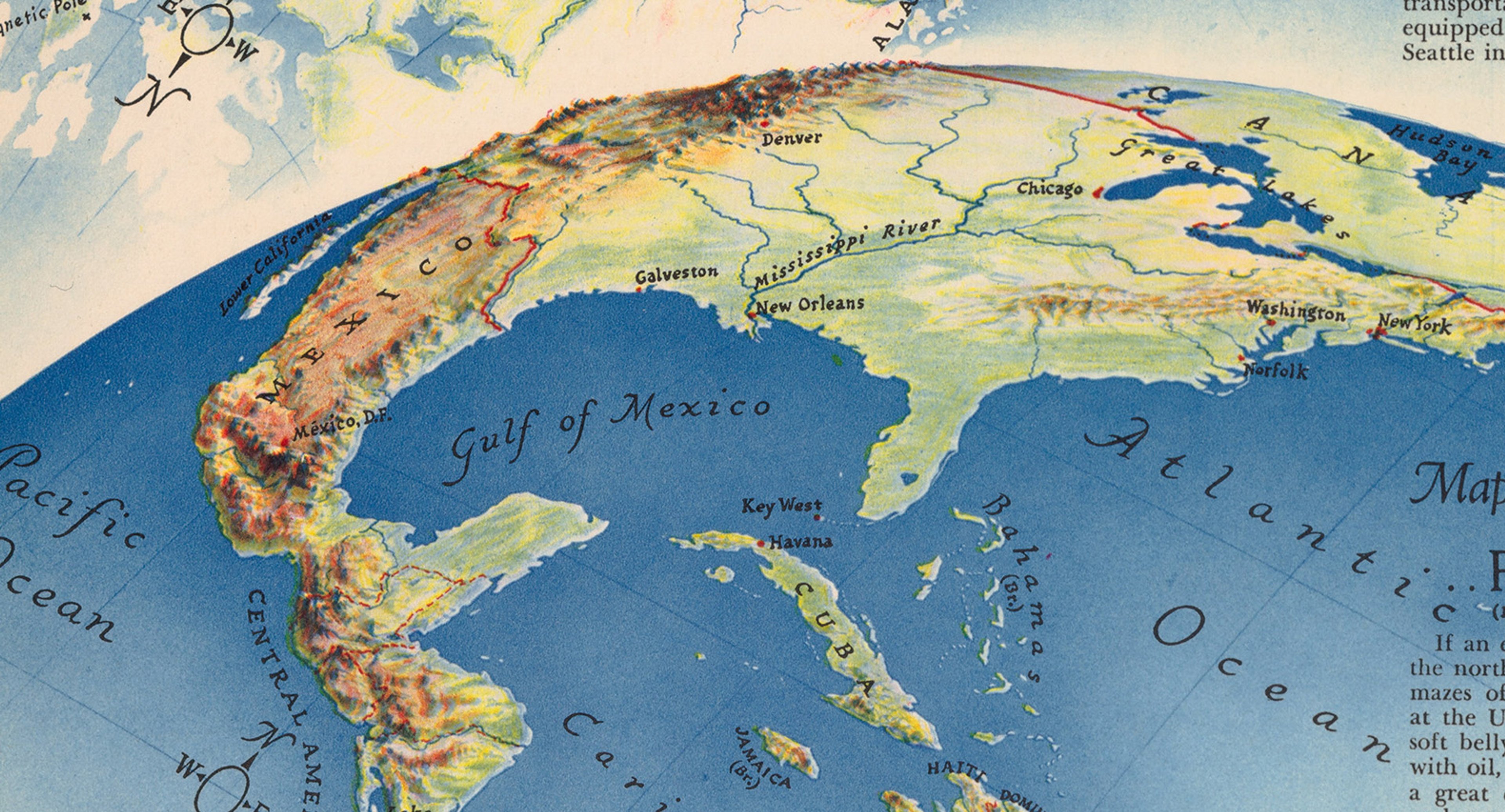
Zoom in on this fantastic map as Susan and Jerry discuss it. The second map is further below!
"Three Approaches to the U. S.", or "How Others See Us" Maps 9 - 11 from Fortune Magazine, Sept. 1940. Deriving from Cornell University – PJ Mode Collection of Persuasive Cartography.
This striking map shows potential military approaches to the United States, highlighting its vulnerability to a possible attack. The map was published in 1940, during the Second World War.
The first section of the map, Map 9, shows a hypothetical German attack via a ‘corridor of invasion’ originating in Berlin and crossing the Arctic and Canada. The second, Map 10, shows a possible Japanese attack from Tokyo coming directly across the Pacific Ocean using Asian ports. And finally, Map 11 illustrates an attack from the northern coast of South America and the ‘maze’ of the West Indies, landing on the United States’ East Coast.
Using unfamiliar perspectives and exaggerated-relief curved projections, Harrison's map was designed to emphasise aviation and shipping approaches in accordance to great circle navigational routes - a practice of piloting a plane or ship the shortest distance between two plotted points on a globe.
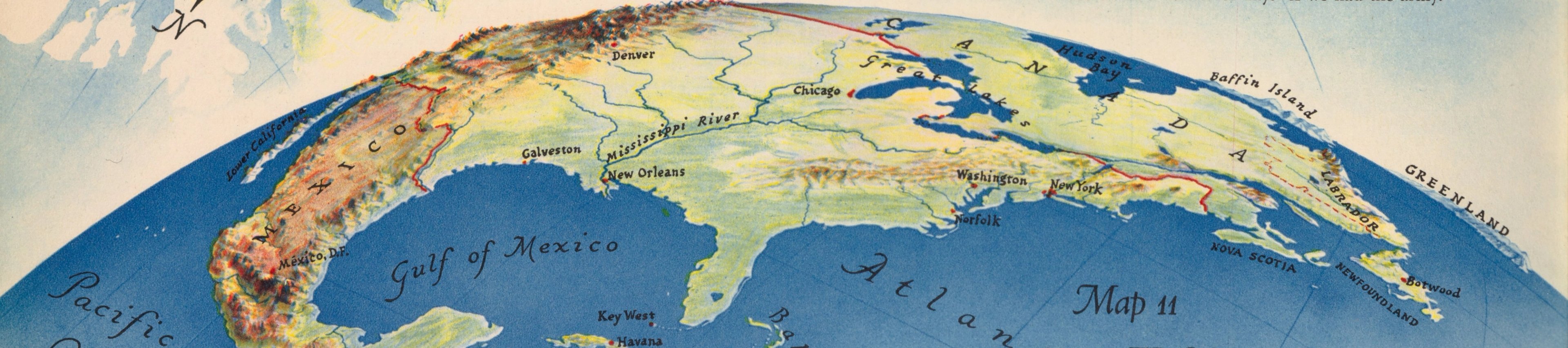
Red lines are used to mark the ‘zones’ of US defensive strategy and a national obligation to protect other countries. Each map is accompanied by text setting out theoretical economic and logistical implications of a conflict using persuasive and playful language. (Susan describes Harrison as a "cheeky" writer!)
This sheet of maps comes from the ‘Atlas for the U. S. Citizen’, a 14-page article issued in the influential business periodical Fortune Magazine, in September 1940. The introduction to the Atlas reads:
“The citizen wishing to review his ideas of foreign policy in terms of geography is here presented with a series of eleven maps together with an economic chart. All of the maps are based on views of the world as a sphere and all are U. S.-centric - that is, they look from or toward the U. S. The first eight maps locate, if they do not fully outline, all parts of the world except Antarctica, as seen from some point within the U. S. defense zone. In the last three maps the direction is reversed, and the U. S. is seen in turn from Europe, Asia and South America.”
The innovative perspective of the maps give the viewer the impression they are tracing above the surface of the Earth. They were created using reference photographs of a mighty 60-inch diameter globe made for the American Bible Society by the esteemed American Geographic Society cartographer William Briesemeister (1895-1967) - similar to The President’s Globe.
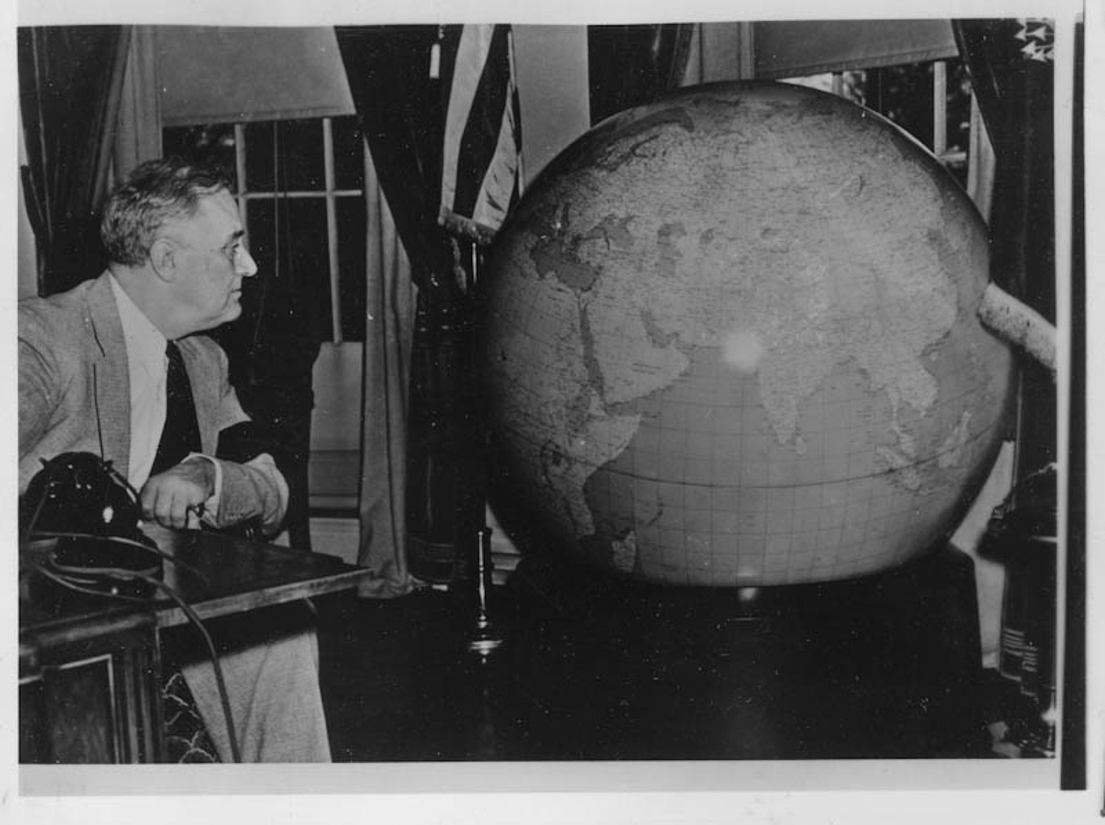
Franklin D. Roosevelt presented with The President's Globe by the United States Army at the White House in Washington, D.C. Dec. 1942. © Franklin D. Roosevelt Presidential Library & Museum. Public Domain.
Richard Edes Harrison was a gifted artist whose innovative and unorthodox maps offered a fresh perspective of the world, breaking the mould from the traditional “north is up” understanding, the use of the Mercator projection, and paving the way for historians and journalists to dynamically illustrate their articles.
Harrison’s maps attempted to shake up what he saw as "cartographic lethargy" in the U. S. at the time: they aimed to help Americans better understand the global world in which they lived. He showed just how close to home the seemingly remote international war was, emphasizing that this was a global war that the United States could not avoid. Harrison's maps also highlighted the development and use of aviation technology, and how that might revolutionise war and concepts of distance.
Following the loss brought about by the First World War and the Great Depression, 1930s America adopted a policy of isolationism, remaining separate from the political affairs and conflicts of other countries and groups. While there were of course defence procedures in place to protect the U. S.’s international interests and territories, this advocacy for the non-involvement in the intensifying conflicts in Europe and Asia caused isolationists and internationalists to butt heads.
In 1934, the influential book “Merchants of Death: A Study of the International Armament Industry” was published by Helmuth C. Englebrecht and Frank C. Hanighen. It exposed the financiers and backers of the arms industry and fuelled the debate surrounding Lend-Lease - the policy of providing aid rather than military involvement and support for other countries in crisis. Many people felt that the U. S. had been dragged into the First World War by the munitions manufacturing industry.
As the situation in Europe was becoming desperate, the British Prime Minister Winston Churchill reached out for support and supplies from America in the fight against Nazi Germany. In an address to U. S. Congress in 1941, he pleaded, “Give us the tools and we will finish the job”.
The Lend-Lease Act was signed into law in March 1941. Formally "An Act to Promote the Defense of the United States,", it was created to allow America to provide military aid and goods to its allies during wartime without the requirement for immediate repayment.
Portrait of Henry Luce taken by New York World-Telegram and the Sun staff photographer Phil Stanziola in 1954. Public Domain, via Wikimedia Commons.
One of the most prominent thought leaders within internationalism was Henry Luce (1898-1967) - a man responsible for producing three of the most influential publications of the 20th century: Time, Life, and Fortune Magazine. As well as being a capitalist and founder of a publishing empire, he was a philanthropist. On March 3 1923, the very first issue of Time Magazine was published, featuring international and national current affairs, and also more minor news from the daily papers. Its powerful editorial rhetoric would be written from a stance of being strongly in favour of involvement overseas.
Following the release of popular Time Magazine, Luce launched Fortune Magazine in 1929, a monthly journal aimed at the business community. His third periodical was Life (established 1936), a weekly magazine full of spectacular imagery that brought the wider world into people's homes. All of these iconic publications promoted internationalist views.
Harrison's strong, unique maps helped to illustrate the written editorials in Fortune. His signature style was to remove geographical elements from maps, keeping only the physical terrain and most important reference points. Harrison’s strength lay in his ability to take cues from the editors, and capture the geopolitics of the moment.
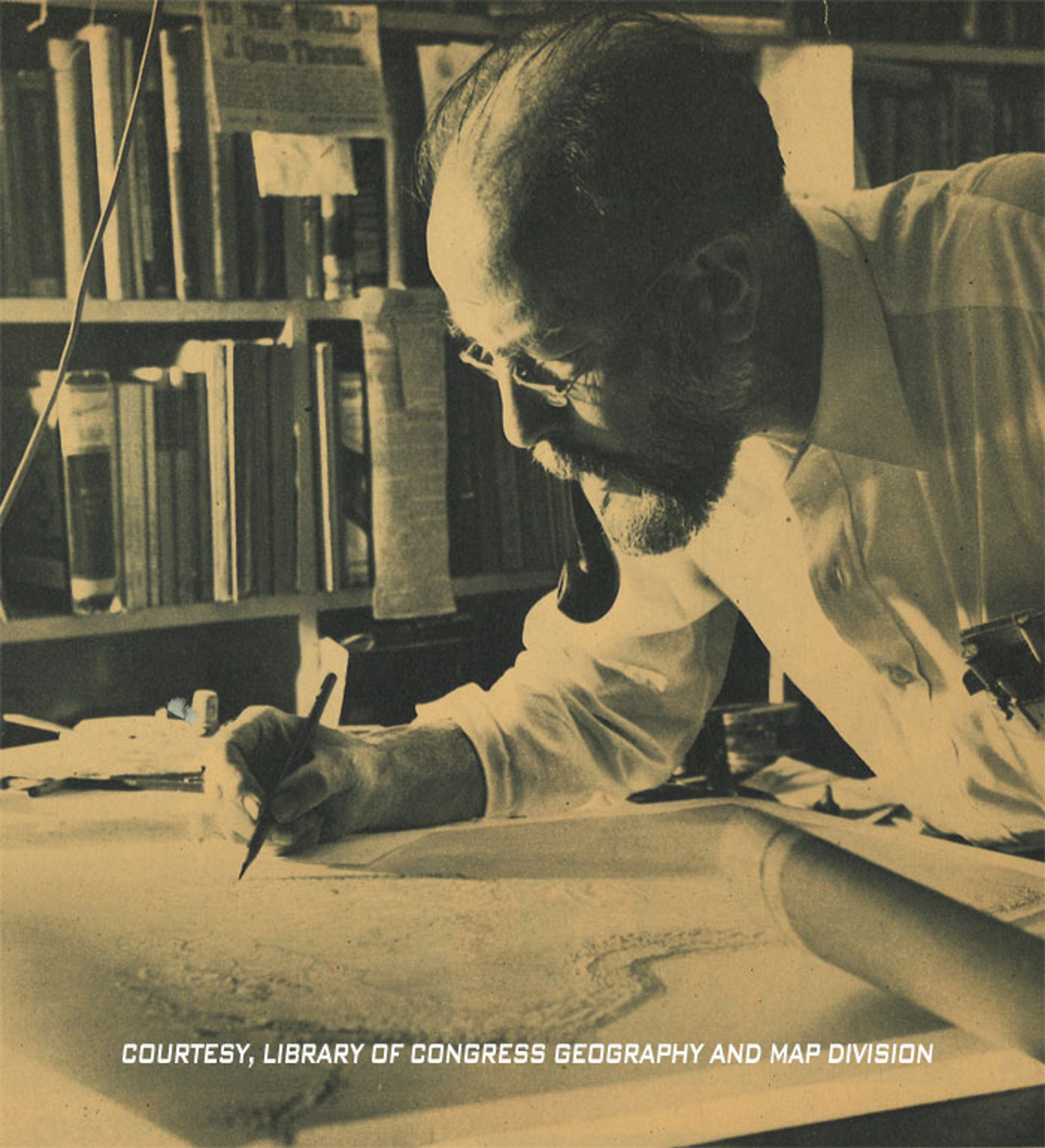
Richard Edes Harrison working on a map © Courtesy of the Library of Congress, Geography and Map Division.
Richard Edes Harrison (1901-1994) was born in Baltimore, Maryland. His family moved to New Haven in Connecticut when his father, a prominent scientist at Johns Hopkins University, transferred to Yale University.
Harrison started his artistic journey by creating scientific illustrations for his father and his fathers’ colleagues. In 1923, he began a degree in zoology with a minor in chemistry, but by 1926, Harrison changed to studying architecture at Yale’s School of Fine Arts. Unusually for the time, architecture was taught alongside subjects such as painting and sculpture, as opposed to surveying and engineering, which ultimately meant that Harrison would be able to develop his style as an artist.
When The Great Depression hit in 1929, Harrison pivoted from architecture to design due to lack of work. He was asked to step in for another designer by a friend working at Time Magazine and would be commissioned to produce a map visualising the predictions for the 1932 Presidential Election. Three years later, he was hired as a permanent cartographer at Fortune Magazine.
Harrison went on to create a multitude of illustrative maps and politically persuasive atlases for the Magazine. As well as journalistic periodicals, companies like Pan American Airways employed him to create maps to showcase their international routes and encourage travellers to new horizons.
His techniques defied convention and created a new standard for the look and shape of the world on a map. Harrison designed the maps to be both visually appealing and politically charged, reflecting the urgency of the war while also maintaining an elegant artistic dimension.”
- Susan Schulten (1998). 'Richard Edes Harrison and the Challenge to American Cartography'. Imago Mundi, vol 50: p174
The second map presented by Susan on the podcast is another masterpiece by Harrison, ‘The World Divided - The World Centrifuged’. Click on the image below to enlarge and explore:
Richard Edes Harrison's "The World Divided - The World Centrifuged", 1941 © David Rumsey Map Collection, David Rumsey Map Center, Stanford Libraries. Creative Commons License
This unusual map was published in Fortune in August 1941, showing the state of the crisis a few months into Lend-Lease. Illustrated routes both by air and by sea chart deliveries of supplies and financial aid - the thickness of the line showing the depth of commitment. The colour coding across the map shows the allegiances between the Allies (shades of red), those neutral to the conflict (yellow), and the Axis (a sinister dark red or black).
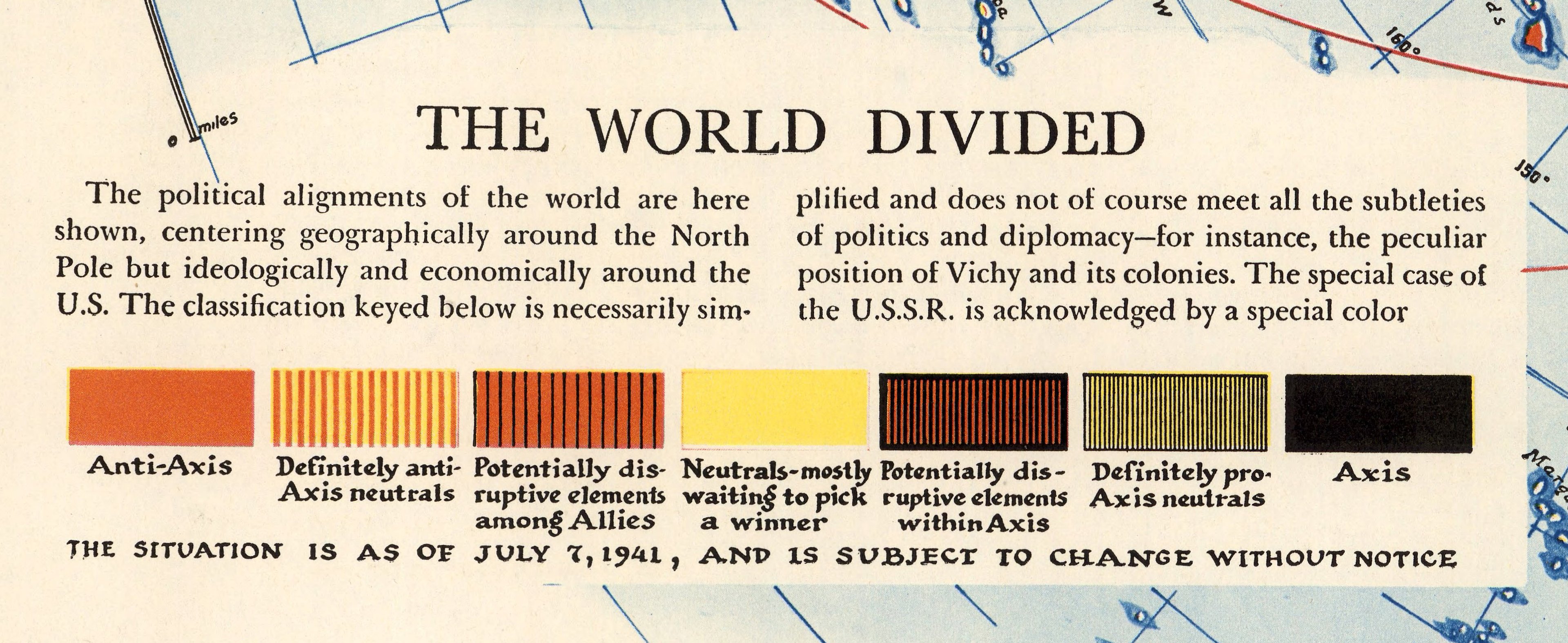
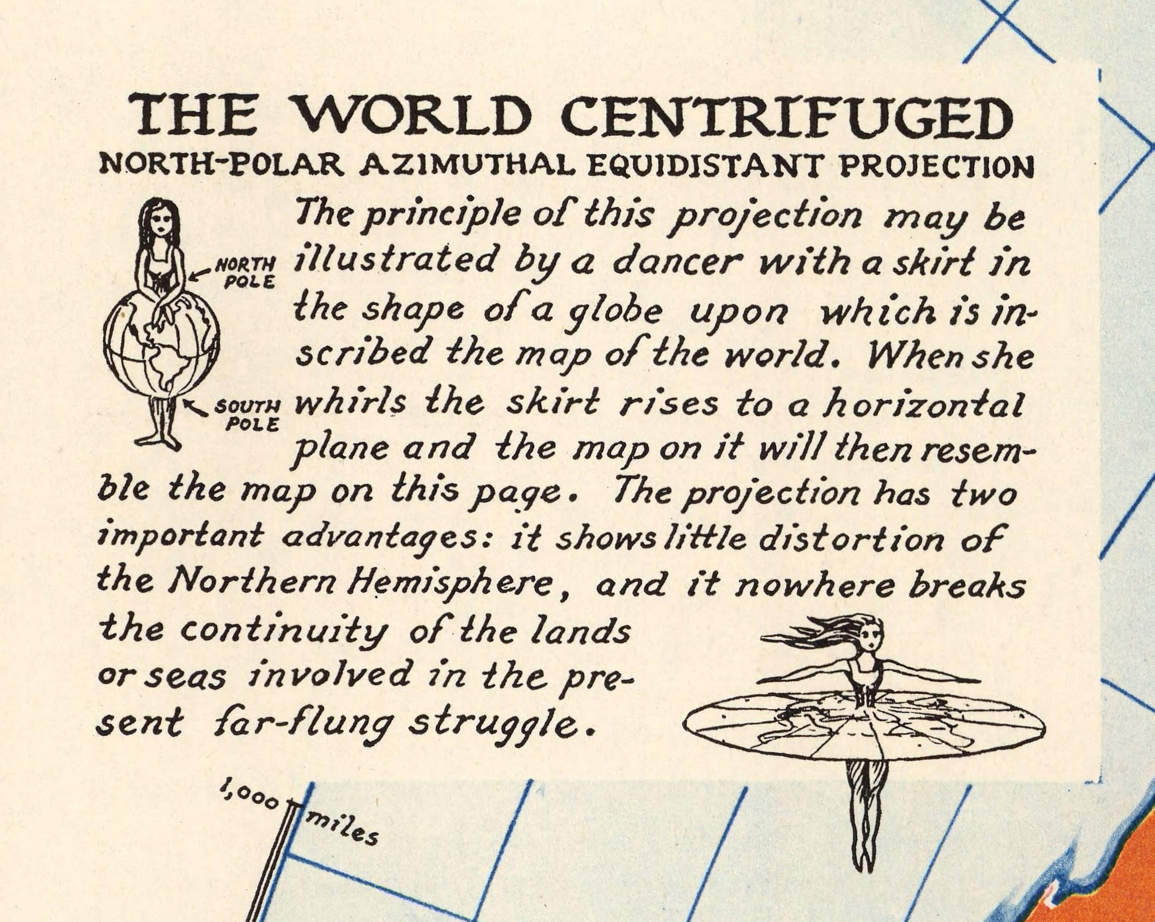
Harrison’s use of alternative projections provided the reader an ability to shift between these different perspectives of the world, and ‘give them a much more powerful understanding of world relationships’.
The north-polar azimuthal equidistant projection used in Harrison, like this 1941 map, heavily influenced designer Donal McLaughlin when creating the prototype identity for the United Nations in 1945!

The United Nations Flag, flying at United Nations Plaza in the Civic Center, San Francisco, California, USA. © Makaristos. Public Domain via Wikimedia Commons.
About Susan Schulten

Susan Schulten is a Distinguished University Professor of History at the University of Denver.
She is the author of many brilliant books on the history of mapping, including A History of America in 100 Maps (2018); Mapping the Nation: History and Cartography in Nineteenth-Century America (2012); and The Geographical Imagination in America, 1880-1950 (2002). Her most recent book is Emma Willard's Maps of History (2022).
She received her B.A. from the University of California at Berkeley, and her doctorate from the University of Pennsylvania.
In 2010, she became a Fellow of the John Simon Guggenheim Memorial Foundation and was awarded a Public Scholar Fellowship from the National Endowment for the Humanities in 2016. She became the Distinguished Fellow in Residence at the American Antiquarian Society for 2024-25.
This year, she will serve as a Colorado State Historian, during the 150th Anniversary of Colorado Statehood, and the 250th Anniversary of American Independence.
A new episode of WHAT'S YOUR MAP? will be available every two weeks. Why not continue your exploration of the wonderful world of maps by subscribing? That way you'll never miss an episode.
Feel free to let us know - What's YOUR Map?!

