Richard A. Pegg
Series 5 Episode 2
The Beauty of Blue with Dr. Richard A. Pegg
Series 5 Episode 2
Available on all major podcast platforms: click the icons or hit 'play' to listen now.
This week, Jerry meets Dr. Richard A. Pegg, the Director and Curator of Asian Art at the MacLean Collection, Asian map aficionado, and proud owner of Blue China Map shoes!
The MacLean Collection is an amazing private collection of Asian art and global cartography. Based in Chicago, it is home to over 5,000 historic artefacts and more than 35,000 maps.
In this episode, Richard and Jerry discuss two majestic wall-maps from the Qing Dynasty, known colloquially as the ‘Blue China Maps’: the ‘Complete Geographical Map of the Everlasting Qing Dynasty’ by Huang Qianren (c.1820) and the ‘Complete Celestial Chart of Equatorial Fixed Stars’ by Yunyou Sanren (c.1822).
Richard explains the complex world view behind these maps and what they would have meant to someone consulting them during 19th Century China. He reveals how they were made, the source of their stunning blue colouring - and how they reflect the imperial Mandate of Heaven.
To explore the maps while you listen, click on the images below:
©The Sunderland Collection
The title of the map is ‘Daqing Wannian Yitong Dili Quantu' - 大清萬年一統地理全圖 - meaning the ‘Complete Geographical Map of the Everlasting Unified Qing Dynasty’. The Qing Dynasty was the last of the Imperial dynasties of China, lasting from 1644 to around 1911. This extraordinary map was made in Shuzou, a major centre of artistic production.
The map is colloquially known as the ‘Blue Map of China’ and is one of the most well-known Chinese maps ever made. Much of the information displayed on it is based on research originally presented to the Qianlong Emperor by Huang Qianren in 1767. It reaffirms the status of the empire as the geographical, political, and cultural centre of the world and reflects the enduring influence of the Qing Dynasty as an authority on geographical understanding.
The Blue China Map served as a highly detailed and efficient organisational resource. Using a hierarchical system of borders and styles, the map specifies administrative divisions including cities and prefectures, topographical features such as the Great Wall and navigable rivers, and places of strategic significance.
Richard and his colleague Elke Papelitzky have identified ten different editions of this beautiful map dating between 1820 and 1826. The example in the Sunderland Collection is dated circa 1820 and is a sixth edition example (known as ‘Type F’). You can find out more about this copy here and zoom in on the image below:
©The Sunderland Collection
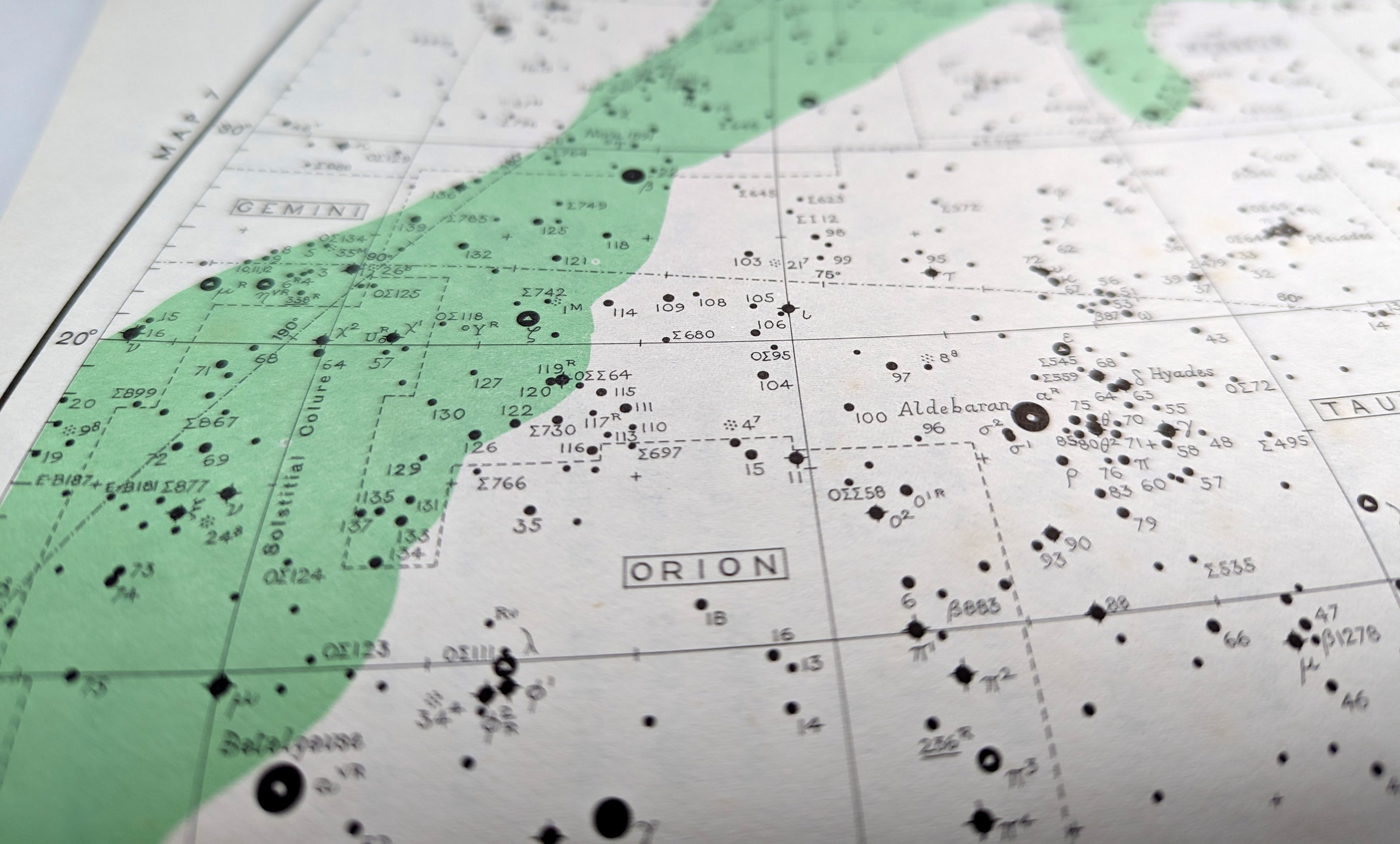
This dazzling blue map of the sky is titled 'Huntian Yitong Xingxiang Quantu' - 渾天壹統星象全圖 - or 'Complete Celestial Chart of Equatorial Fixed Stars'. Made by Yunyou Sanren, it was one of the largest such maps published during the Qing Dynasty and combined both Chinese and Western astronomy.
The map highlights the fundamental role that knowledge of the Heavens played in Chinese politics, and illustrates the efforts of Qing scholars and leaders to seek authentic truth in ancient texts. Using two distinct types of script, the map confirms the authority of the Emperor to act as an ‘arbiter between Heaven and Earth’ and the ultimate earthly power - often referred to as the Mandate of Heaven.
Richard also highlights the significance of Ursa Major, or 'The Big Dipper,' in Chinese culture. Due to its prominent appearance in the night sky and its daily rotation of one degree, the constellation was historically essential for charting the heavens. This constellation appears in the centre of the map, and is the only common grouping of stars between Chinese and European cartography of the time.
Richard and Elke have determined six editions of this stunning map, dating between 1820 and 1826. This particular copy is from 1822. You can find out more about it here and zoom in on the details below:
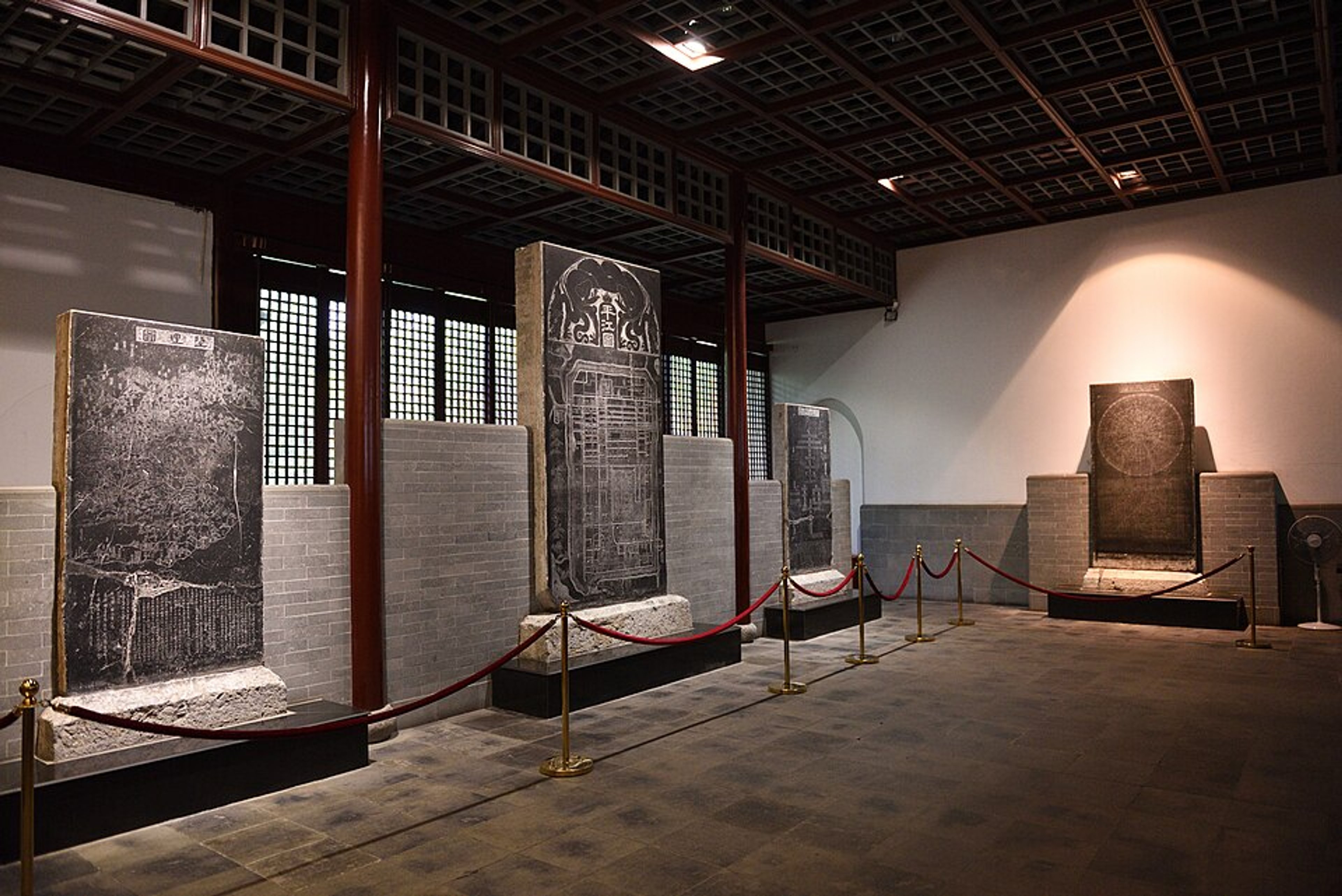
Suzhou Stone Inscription Museum by Siyuwj via Wikimedia Commons
The contents of both these stunning wall-maps derive from maps created in the 1190s by Huang Shang (1146–1194), the tutor to Emperor Guangzong’s son. Because of their importance, his maps were etched onto stone steles - carved upright stone pillars - in 1247 CE by Wang Zhiyuan (1193–1257) and housed in the Confucian Temple in Suzhou, which is now the Suzhou Stone Inscription Museum.
Since that time, rubbings from those stone steles have been made, collected, studied, and coveted.
In the two present examples, the maps were each mounted onto eight hanging scrolls and printed in a strikingly rich pigment known as Prussian Blue.

Prussian Blue pigment. Saalebaer via Wikimedia Commons.
Johann Jacob Diesbach, a paint-maker from Berlin, reportedly created Prussian Blue by accident in around 1704. He was attempting to produce a red pigment called Florentine Lake using iron sulfate, potash, and crushed insects when the colour materialised. Diesbach turned his error into a commercial opportunity and first marketed it as Berlin Blue.
British traders first exported this vibrant pigment to China in the 1790s. By the early 1800s, it was being manufactured domestically in Canton (modern Guangzhou). According to Richards's research, the large quantity of Prussian Blue produced for the Blue Map printers represents the first extensive application of this pigment in East Asia.
The popularity of Blue China Maps in Japan - which were used on folding screens and sliding doors as well as folding maps - suggests that the large-scale production of Prussian Blue in China might have been a catalyst for the 'blue revolution' among Edo-era Japanese print artists such as Hokusai and Hiroshige.
About Dr. Richard A. Pegg

Dr. Richard A. Pegg is the Director and Curator of Asian Art for the MacLean Collection, an Asian art museum and map library located north of Chicago.
He has written and lectured widely on the visual, literary, cartographic, and martial arts traditions of East Asia.
Richard is the author or co-author of The Maclean Collection: Chinese Ritual Bronzes (2010), Cartographic Traditions in East Asian Maps (2014), Highlights of Asian Art: The Maclean Collection (E-book, 2015), Chinese Swords: An Ancient Tradition and Modern Training (2015), The Chinese Jar (a novel, 2015), The MacLean Collection: Early to Medieval Chinese Pottery (2023). His forthcoming publication, The Blue Maps of China: Heaven and Earth in the Early Nineteenth Century, sheds further light on the astonishing pigments and history of these beautiful maps.
©Richard A. Pegg
The MacLean Collection
The MacLean Collection Asian Art Museum and Map Library consists of nearly forty thousand maps and printed material that date from the fifteenth century to the present.
Located in the north suburbs of Chicago, the map collection was begun by Barry MacLean in the early 1960s and continues to expand today. It includes a broad range of media and formats such as globes, wall maps, sheet maps, pocket maps, case maps, atlases, manuscript maps, relief maps, pictorial maps, Portolan charts, posters and cartographic games and puzzles.
There is cartographic material covering all parts of the world, but the collection’s strengths include maps of the discovery and exploration of the Great Lakes, maps and atlases of American states and counties, British county maps, nineteenth century American maps, wall maps, and maps of the world.
Find out more by visiting macleancollection.com
Why not continue your exploration of the wonderful world of maps by subscribing to the podcast? That way you will never miss an episode.
And feel free to let us know - What's YOUR Map?!
All views and opinions expressed by guests on the podcast are entirely their own and do not represent those of The Sunderland Collection or Whistledown Productions.