Elizabeth Hogan
Series 3 Episode 1
One World, One Ocean... One Climate with Elizabeth Hogan
Series 3 Episode 1
Available on all major podcast platforms: click on the icons below or on 'play' to listen now.
Welcome to What’s Your Map? In this episode, Jerry speaks to Elizabeth Hogan, a marine biologist, Programme Director at the National Geographic Society, and a passionate advocate for marine conservation.
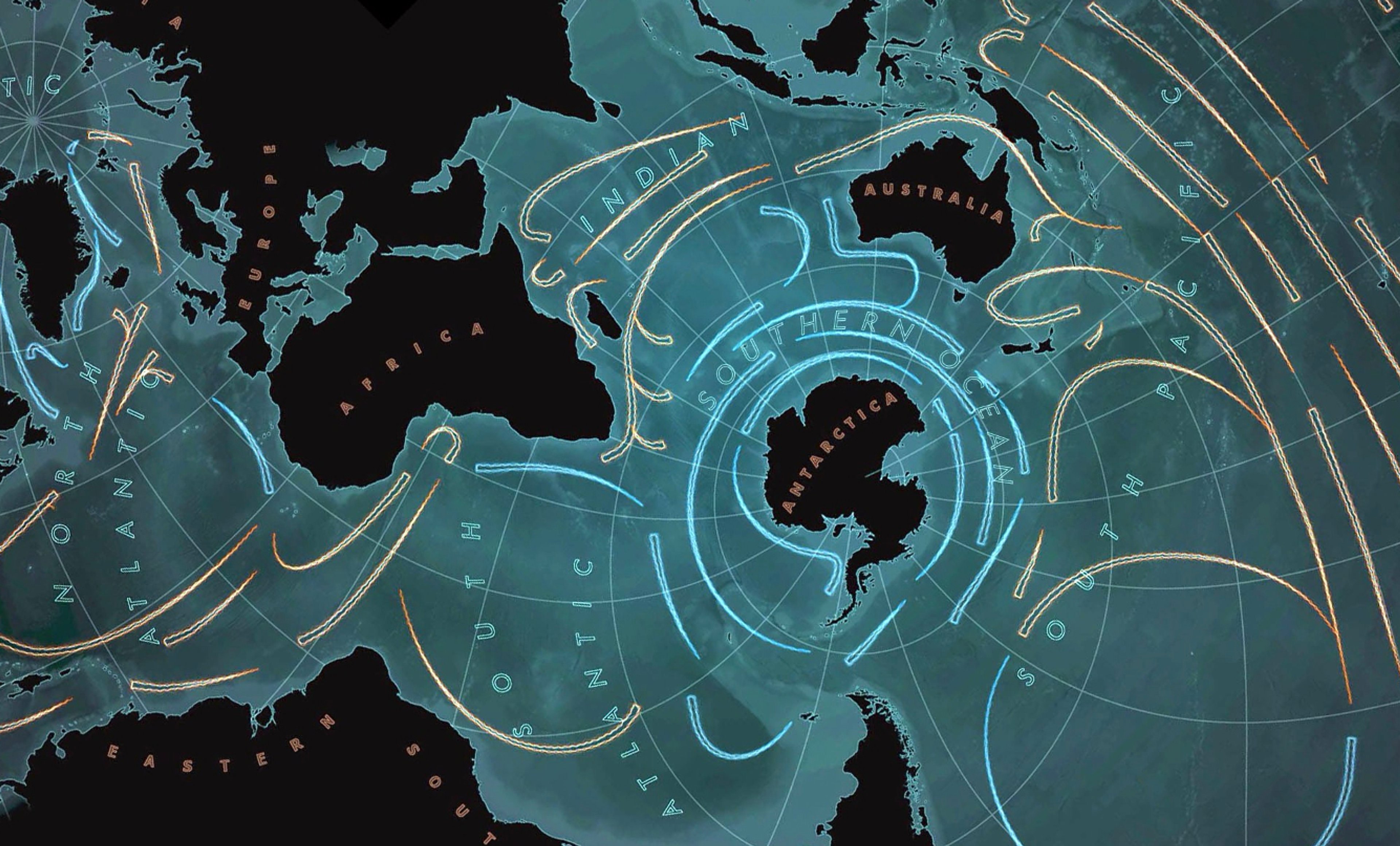
Having spent over 15 years dedicated to protecting marine ecosystems, Elizabeth shares her experience while discussing a unique map that reorients our understanding of the world's geography. She explains how this ocean-centric map from the Environmental Systems Research Institute (Esri), illustrates the reality of our planet's interconnected bodies of water: that we have one global ocean rather than distinct, isolated seas.
Elizabeth also reveals the significance of ocean currents, which are prominent on the map. She explains how they link distant regions, affecting everything from the migration patterns of marine species, to the transportation of plastic waste and the lives of coastal communities.
To dive in to a high-definition image of the Esri One Ocean map during the podcast, click on the image below:

Esri One Ocean Map with directional blue and gold arrows to depict the warm and cold ocean currents, and using a basemap showing visible Earth bathymetry from NASA. Created by John Nelson, using preliminary projection mapping by David Burrows and Bojan Šavrič. Certain Esri satellite imagery in this work are owned by Esri and its data contributors and are used herein with permission. Copyright © 2025 Esri and its data contributors. All rights reserved.
By centring on the ocean, this map illustrates just how interconnected and inter-dependent the world of water is with the rest of our earth - after all, the ocean covers 71% of the planet’s surface.
The ocean plays a vital role in our lives. It is essential for climate regulation, oxygen production, food, resources, and livelihoods. It is home to multitudes of diverse marine life and responsible for their migratory patterns. The temperature of water in the ocean has a direct impact on maintaining the delicate balance of marine ecosystems; and as Elizabeth has experienced throughout her career, the ocean transports harmful materials such as fishing gear and other plastic waste around the world in huge volumes and at incredible speed.
Understanding the ocean is therefore incredibly important to everyone, particularly in this era of dramatic climate change.
Esri is a multinational headquartered in California, best known for its ArcGIS mapping products. Esri’s map adopts the Spilhaus Projection, invented in 1942 by South African-American geophysicist and oceanographer Athelstan F. Spilhaus (1911–1998). This projection has been updated to use the Adams Square II projection by Oscar S. Adams, which depicts the world in a square.
Spilhaus devised this world view by selecting two points situated exactly opposite to one another on the Earth’s surface, which would act as the centre of each hemispherical projection, being careful to choose a point that would intersect the ocean as little as possible, thus seamlessly connecting the bodies of water around the continents. It's digitisation as an open-source data means it can be used to map ecosystems and sea life migration, track currents and map water temperatures, and so much more!

Copyright © Quizimodo, using map by Henry Bottomley. Public Domain, via Wikimedia Commons.
This animated map shows an alternative view of the global ocean encircling the Earth, depicted on an azimuthal equidistant projection map.
The map is centred on 85° W, 45° S off the coast of southern Chile, rotated 90° CCW, with the North Pole to the left. The ocean boundaries are shown based on data from the International Hydrographic Organisation. Other substantial bodies of water, the Caspian Sea and the Great Lakes, are shown in black.
For centuries, navigators harnessed the power of the ocean currents for trade and exploration. However this map, from 1665, is perhaps one of the earliest maps to attempt to depict the natural phenomena of the ocean currents. Using finely engraved lines, sweeping currents are shown connecting the bodies of water, and more densely engraved sections highlight deeper trenches on the ocean floor.

This map derives from Athanasius Kircher’s work 'Mundus Subterraneus' ['Subterranean World'], published in 1665. An extraordinary encyclopaedia of underground geography, it presents pioneering speculations on the flow of water, air, and fire in and around our World. You can see Kircher's theory on underground water reservoirs here.

Portrait of Kircher from Mundus Subterraneus by Cornelis Bloemaert © Portrait Index. Public Domain.
Athanasius Kircher (1602–1680), a German Jesuit scholar and polymath, authored approximately forty major works spanning comparative religion, geology, and medicine. He is often likened to Renaissance polymath Leonardo da Vinci for his extensive interests and subject interrogation.
The Southern Ocean does not feature on this Kircher's map: instead it shows a speculative large southern continent, ‘Terra Australis Incognita’ [‘Unknown Southern Lands’].

Copyright © The National Maritime Museum, United Kingdom, Public Domain, via Wikimedia Commons
It would be another 108 years until the first recorded Europeans would cross into the Antarctic Circle at latitude 66° 36' South; Captain James Cook and his crew in 1773 aboard the HMS Resolution during Cook's second circumnavigation voyage.
This famous portrait of English Sea Captain James Cook (1728-1779) is by painter Nathaniel Dance-Holland , c1775. In it, he holds his own chart of the Southern Ocean and points to the east coast of Australia on it.
The discovery of Antarctica would not happen until 1820 when Russian cartographer and explorer Fabian Gottlieb van Bellingshausen (1778-1852) reported seeing ice shelves connected to the Antarctic mainland. Other explorers also sighted land around the same time include Edward Bransfield, just three days after Bellingshausen!
The Southern Ocean itself was not formally recognised as the fifth ocean until 1999, and was officially named on World Oceans Day, 8 June 2021. This ocean connects the Atlantic, the Pacific and the Indian Ocean, and sustains around 10,000 different species!

Copyright © Public Domain, via NASA
The Southern Ocean is affected by the Antarctic Circumpolar Current, a powerful and important current which flows clockwise from west to east forming a closed loop around the Antarctic continent. It is a vital part of the global ocean conveyor belt for regulating the climate and transporting nutrients and water.
This current has been observed by sailors for hundreds of years and is also known as the ‘West Wind Drift’.
This screenshot is taken from the NASA / Goddard Space Flight Center Scientific Visualization Studio shows the Antarctic Circumpolar Current.
This current speeds up travel from west to east, but makes seafaring journeys from east to west incredibly difficult. It provided the fastest eastbound sailing route for mid-nineteenth century merchant vessels known as ‘clippers’, who would sail via South East Cape in Australia, Cape Horn in South America, and the Cape of Good Hope and Cape Agulhas in Africa.
Due to the warming of the planet and the climate crisis, the rapid introduction of freshwater from rain, and melting ice and glaciers, the ice cold saltwater in the Antarctic becomes diluted. As well as creating a rise in sea levels, this influx of freshwater warms the ocean and weakens the strength of the current putting the entire food chain at risk - the rise in temperature makes it uninhabitable for a number of species, and means essential nutrients are not circulated around the ecosystem.
Elizabeth was fortunate enough to be part of an all-encompassing expedition in Antarctica in 2024 learning more about how these changes affect even the deepest parts of the Southern Ocean. The researchers she accompanied observed everything from wildlife and vegetation, to geology and weather. She was struck by the collaboration of the scientists and explorers across the different disciplines, all working together and finding solutions for issues. In particular, she was brought joy seeing people learn about the knock-on effect for other areas of research - poetically the same way the Atlantic, Pacific, Indian, Arctic and Southern Ocean impact one another.

Robert Dudley’s sea chart of the western North Atlantic Ocean covering the coastline of New England, from Dell'Arcano della Mare (1647)
Elizabeth grew up in New England, with a love of the ocean, wildlife and travel. Since embarking on her career in international environmental policy has been lucky enough to travel to all seven continents and all five oceans! In the podcast she takes us on a whistle-stop tour of some of the highlights of her career and her work as a Programme Director for Perpetual Planet Expeditions for National Geographic Society: ‘explorer-led science and solutions-focused expeditions to reveal, protect, rebalance and restore our planet's critical life-support systems’.
After graduating from Georgetown University, she worked in Ecuador. During her time working there, she experienced El Niño: a climate phenomenon that warms the ocean and creates a variation in the winds in the central and eastern equatorial Pacific Ocean. She was able to see first hand how this changed conditions for the Latin American coastal fishermen and their communities, as well as how it physically changed the environment in which they worked.

Pair of North American Right Whales © National Marine Sanctuaries - GRNMS. Public Domain, via Wikimedia Commons.
She also describes her time working for the International Fund for Animal Welfare (IFAW), assigned to work protecting the North Atlantic Right Whale - a study close to her heart due to their habitat in near her home in New England.
Their migratory pattern in the western North Atlantic means they travel between their feeding grounds in the Labrador Sea, and and spend the winter months calving off the coast of Georgia and Florida in the south-eastern United States. These mighty mammals were named so because of their being the ‘right’ or correct whale to hunt because of their docile behaviour, staying close to the shore, and their rich blubber content.
They are currently among some of the most endangered whales in the world.
Elizabeth also worked with other fishing communities in the North Atlantic, in Gulf of Maine and in Alaska, looking to solve problems relating to ‘ghost gear’ - lost, abandoned, or deliberately discarded fishing equipment that continues to harm, trap and kill marine life after it's no longer being used by humans. As Elizabeth states, it is the most dangerous form of ocean plastic.

One of the more recent expeditions’ Elizabeth has taken part in, the Perpetual Planet Expedition Amazon, was a scientific exploration of the Amazon River Basin, from the Andes to the Atlantic. Its multidisciplinary, explorer-led approach expanded across six countries and around 4,000 miles, looking at everything from wildlife and waterways, to the local communities that call the basin their home.


The Pink Boto Dolphin by Nortondefeis (CC BY-SA 4.0). Arapaima Fish by Jeff Kubina from Columbia, Maryland (CC BY-SA 2.0). The Yacare Crocodile by Charles J. Sharp / Sharp Photography (CC BY-SA 4.0) All images via Wikimedia Commons.
Elizabeth leaves us with a poignant message to consider: “If you have the chance to step outside to think about the wider planet and what you can do, ... we can all do something .. No human being is powerless!”

Pages from Athanasius Kircher's 'Mundus Subterraneus' (1665) depicting the ocean currents in the Pacific and Atlantic Oceans surrounding the Americas.
About Elizabeth Hogan

Elizabeth Hogan an expert on marine conservation and international environmental policy. She has spent over 15 years protecting the delicate ecosystem of our oceans and is now a Programme Director at the National Geographic Societys' Perpetual Planet Expeditions.
Elizabeth is responsible for the scientific initiatives of the Perpetual Planet Expeditions program, ensuring the alignment between research expeditions, and NGS environmental conservation and exploration goals. As part of the Perpetual Planet team, she works closely with explorers to identify and develop scientific opportunities across multiple expeditions in ocean and rainforest ecosystems.
She previously led the Oceans and Wildlife program for World Animal Protection, where she specialized in ocean plastic pollution, marine mammal entanglement, and sustainable fisheries. In 2015 she co-founded the Global Ghost Gear Initiative, a worldwide coalition dedicated to scientific research on ocean-based plastic pollution and mitigating its effect on marine wildlife, including the rescue of cetaceans and pinnipeds.
She was the lead author of the U. S. Agency for International Development (USAID) handbook on ocean plastic pollution mitigation, and has informed policy on ocean health and fisheries management at the State Department, United Nations, and the Food and Agricultural Organization.
Elizabeth received a B.A. in Foreign Service from Georgetown University, a MSc degree in Sustainable Development from American University and MSc in Marine and Coastal Natural Resources from Universidad para la Paz in Costa Rica.
A new episode of WHAT'S YOUR MAP? will be available every two weeks. Why not continue your exploration of the wonderful world of maps by subscribing? That way you'll never miss an episode.
Feel free to let us know - What's YOUR Map?!

