WHAT'S YOUR MAP? LIVE at the British Library
Mapping Secrecy, at the British Library

Secret Mapping: Mapping Secrecy
On Saturday 25 October, we recorded two live episodes for our award winning podcast, WHAT’S YOUR MAP?
The Sunderland Collection is truly honoured to have been invited by the British Library to collaborate on this exciting live event as part of the programming to accompany their new exhibition, Secret Maps.
It was thrilling to see our wonderful host, Jerry Brotton, record our first live podcasts at such an iconic institution and before a dynamic, engaged audience!
All event photography captured by Haych Digital ©The Sunderland Collection


Nicholas Crane


©Felicity Bryan Associates
Nicholas Crane is a geographer, author and cartographic expert.
He is the recipient of the Royal Scottish Geographical Society’s 'Mungo Park Medal' in recognition of outstanding contributions to geographical knowledge, and of the Royal Geographical Society’s Ness Award for popularising geography and the understanding of Britain.
Nicholas has been the lead presenter on more than 80 BBC films, including the acclaimed Map Man, Great British Journeys, Town, Britannia and Coast. Between 2015 and 2018, he was the elected President of the Royal Geographical Society.
You can find out more about Nicholas here.
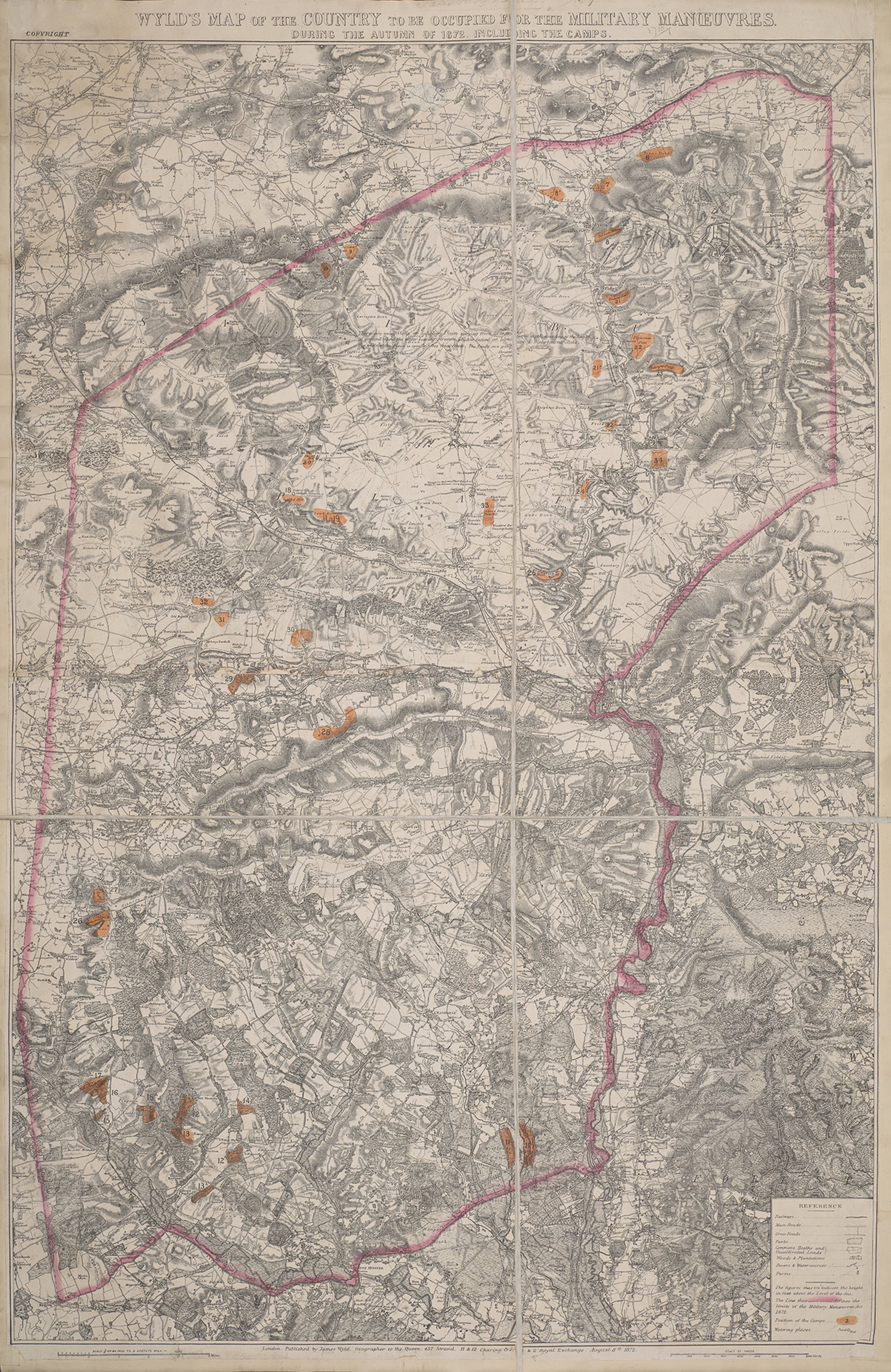
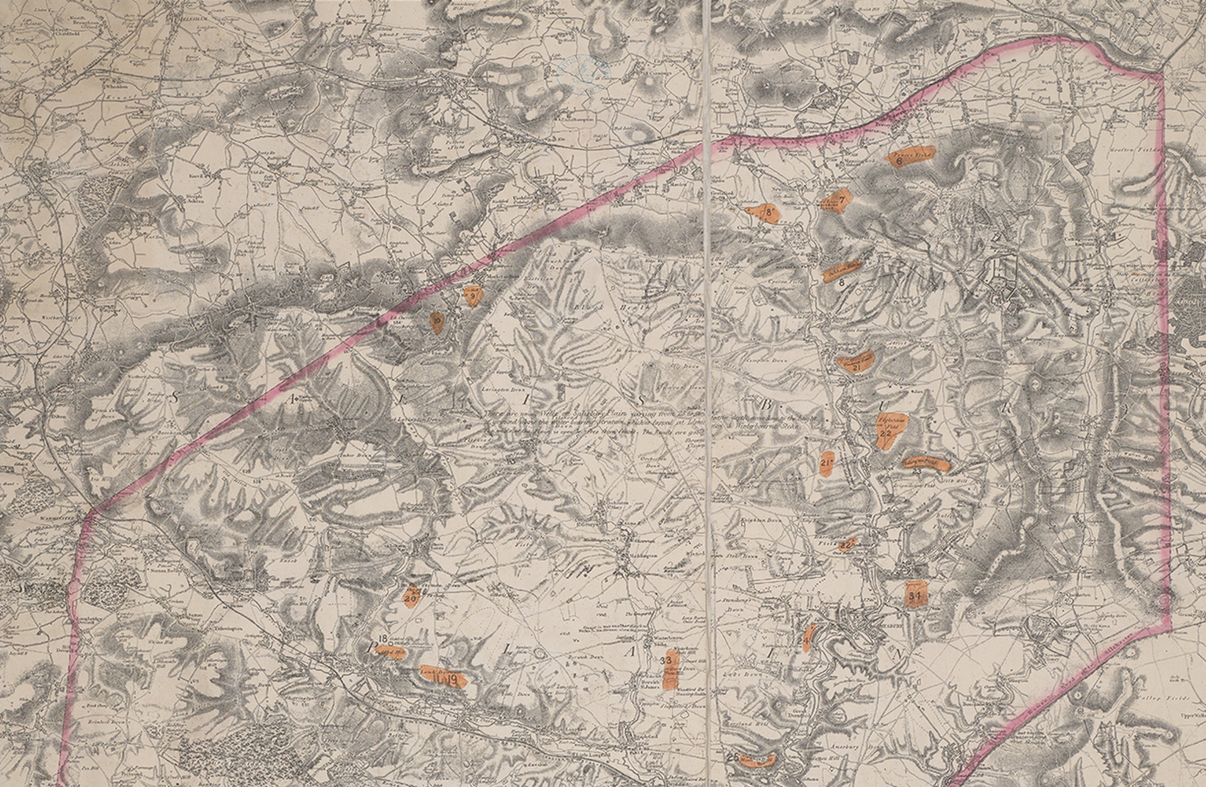
James Wyld's 1872 map of Salisbury Plain ©From the British Library collection. Maps 5710.(1.)
Jerry spoke to geographer, author, and television presenter Nicholas Crane about his chosen map: James Wyld's map of Salisbury Plain, a rare nineteenth century map held within the British Library collection. It demarcates the boundaries of the Military Manoeuvres Act of 1872, an Act of Parliament that gave the War Department permission to hold large-scale military exercises in the countryside.
Nicholas also spoke to Jerry about the innovative map projections of Gerard Mercator and the publishing of his first scientific atlas in 1595. This led them to discuss the accuracy of the maps of national mapping agency Ordnance Survey, and in particular a 1:50,000-scale Landranger map of the Plain.
All of these maps connect to Nicholas' epic walking journey across the UK where he followed a route two degrees west of the prime meridian from Berwick-upon-Tweed on the Northumberland coast, south to the Isle of Purbeck in Dorset, on the south coast.
Watch this live episode here.
Dwayne Fields


©Michael Wharley
Dwayne Fields is an explorer, broadcaster, and the UK's Chief Scout. He advocates for people to get outdoors and explore the world around them – with a particular focus on encouraging young people growing up in inner cities to get out and experience nature and new aspects of life.
In 2010, Dwayne became the first black Briton to walk over 400 miles to the Magnetic North Pole. In 2018, he was presented with the Royal Geographical Society's ‘Geographical Award’ for empowering young people to explore.
You can find out more about Dwayne here.

©Caroline Pantling (EFHT)
Dwayne was joined by Caroline Pantling, Head of Heritage Services for the Scouts Association UK, with in-depth knowledge of Scout history.
Caroline's team looks after a special collection of objects telling the story of the Scout Movement.
You can find out more about the Scout Heritage Collection here.


Public domain, via Project Gutenberg.
Jerry spoke to Dwayne and Caroline about the hand-drawn maps by Lieutenant-General Robert Baden-Powell (1857-1941), the founder of the Scouting movement. They originated from his 1915 novel 'My Adventures as a Spy', a account of his experiences in the military and his career in espionage.
These unassuming drawings of natural history subjects - such as butterflies and leaves - feature cleverly hidden maps and plans of fortresses and armaments.
Together they discussed the impact the Scouts have had on both Dwayne's and Caroline's lives and the history of the Scouting movement in the UK, and adventures on Brownsea Island, during which we learned the importance of being able to read a map!
Watch this live episode here.
About the British Library
The British Library is the national library of the UK. Their shelves hold over 170 million items - including 4.5 million maps – a living collection that gets bigger every day. Although their roots extend back centuries, the British Library aim to collect everything published in the UK today, tomorrow and far into the future. Their trusted experts care for the collections across two sites in London and Yorkshire - opening it up for everyone to spark new discoveries, ideas and to help people do incredible things.
Visit www.bl.uk to find out more, explore their collections and take part in their exciting programme.
The Sunderland Collection and Whistledown Studios would like to extend its sincere thanks to the British Library, in particular to Public Events Manager Jonah Albert and the Events, Production and Licensing Teams for their assistance, support, and coordinating such a brilliant event.

These two live podcasts with Nicholas Crane and Dwayne Fields have been released on Oculi Mundi following the British Library event, and are available to watch our YouTube channel. Click the links below to find out more!
Subscribe to WHAT'S YOUR MAP? - available on all major platforms.