Iris Taylor
Series 3 Episode 2
Introducing Geographical Storyteller Louise E. Jefferson with Iris Taylor
Series 3 Episode 2
Available on all major podcast platforms: click on the icons below or on 'play' to listen now.
In this episode of What's Your Map? Jerry visits the Library of Congress in Washington, D. C. to meet senior librarian Iris Taylor, who has nearly five decades of experience in the map department.
Iris shows Jerry a series of beautiful pictorial maps, created in the 1940s by the pioneering geographical storyteller Louise E. Jefferson. In particular, she highlights a map of ‘Americans of Negro Lineage’ from 1946. This map showcases notable African-Americans from throughout history, including figures like Harriet Tubman - who helped establish the Underground Railroad for escaping slaves - and the poet Langston Hughes.
Louise was one of the first female African-American cartographers. Her work was long neglected, and Iris is working to bring it back to light.
In this conversation, Iris reflects on her discovery of the Jefferson maps, and the profound impact they have had on her. She also talks about her own personal journey as a librarian at the largest and most comprehensive map collection in the world.
To zoom in to this high-definition image of this fascinating map as it is discussed:
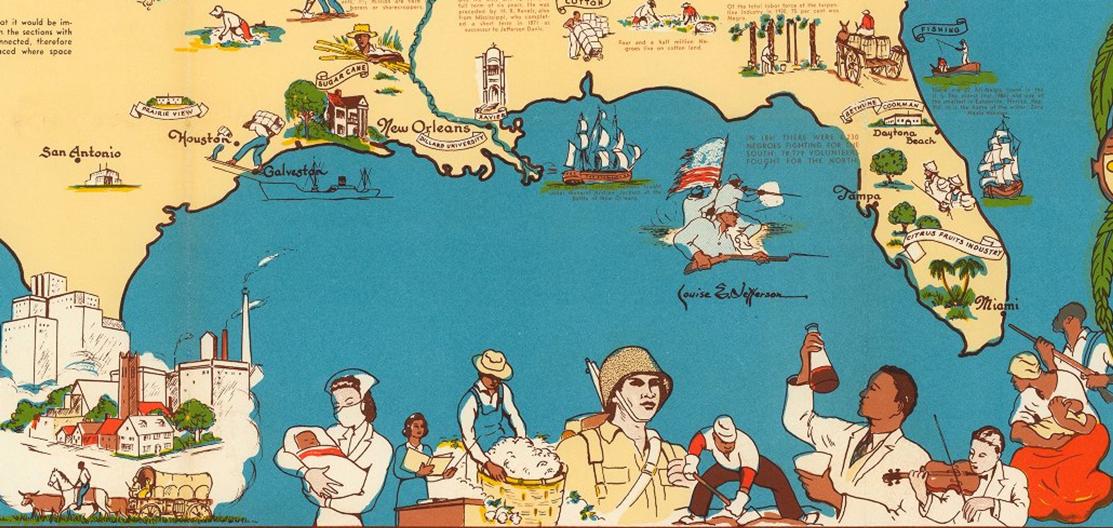
Americans of Negro lineage. Map by Louise E. Jefferson, 1946 © David Rumsey Map Collection, David Rumsey Map Center, Stanford Libraries. Creative Commons License.
This remarkable and vibrant map is a celebration of achievements and important moments in Black history throughout the United States and southeastern Canada. It was created in 1946 by Louise E. Jefferson (1908-2002), a trailblazer in pictorial cartography and one of very few Black women mapmakers during the mid-twentieth century.
Designed as an educational resource for a young audience, the map features likenesses of past and contemporary local heroes and world famous figures. However, the map also presents less well-known members of the community that played an important part in its history. Louise pinpointed landmarks and locations important to Black culture, and used eye-catching vignettes to depict turning points in history. An inset map is included listing the Black population across the US according to a Census taken in 1940.
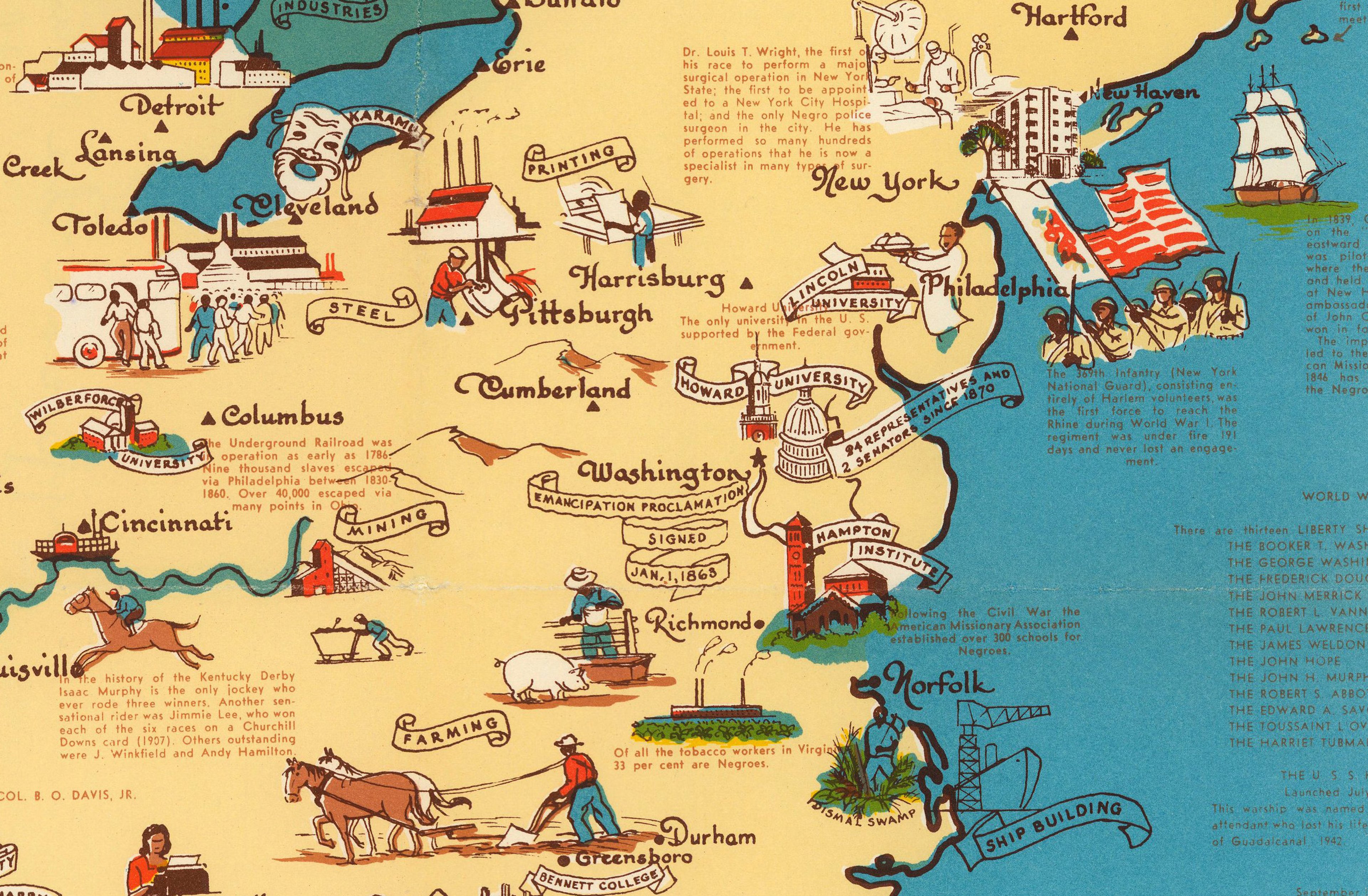
While this map emphasises positive accomplishments and is very much a map of human geography: Jefferson, an African-American woman, chronicles Black history at a time of severe racism, inequality and segregation. Accompanying joyful and celebratory imagery, she shares statistics that highlight the racial disparities and social injustices.
The map is full to the brim with landmarks and historical notes, and the neatline bordering the map lists the names of 54 prominent African-American activists, educators, politicians, scientists, artists, doctors, military personnel, writers, journalists and more, all who have been changemakers in their field. Some of the notable figures include:
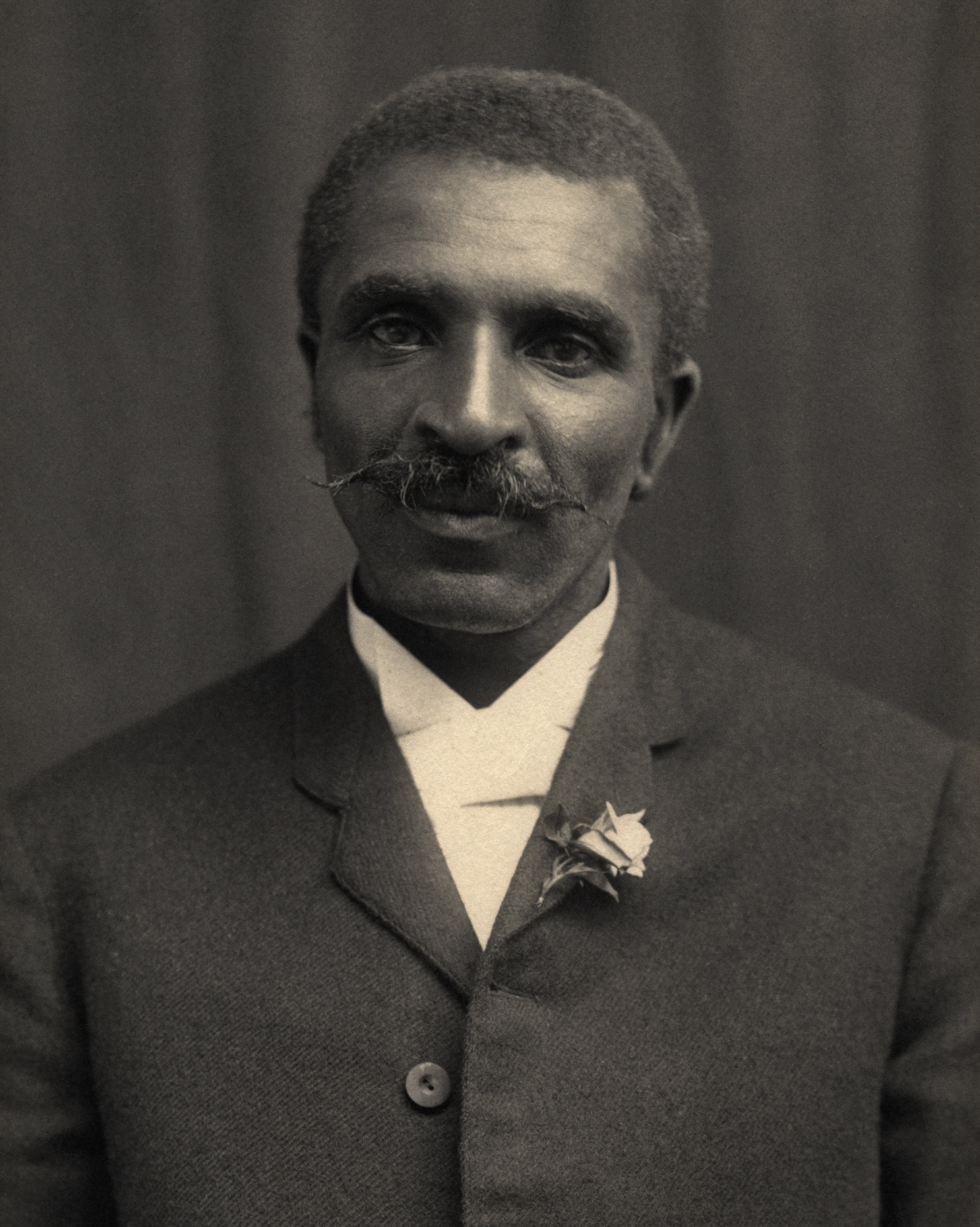
Portrait of George Washington Carver circa 1910 © Adam Cuerden - Tuskegee University Archives / Museum, Public Domain, via Wikimedia Commons.
George Washington Carver (1864-1943) is framed at the very upper centre of the map.
Born into slavery in Missouri, Carver went on to become a world class agricultural scientist, environmentalist, and inventor, who from crops such as peanuts and sweet potatoes, went on to create hundreds of useful everyday products in order to encourage help improve the lives of farmers and those with small holdings.
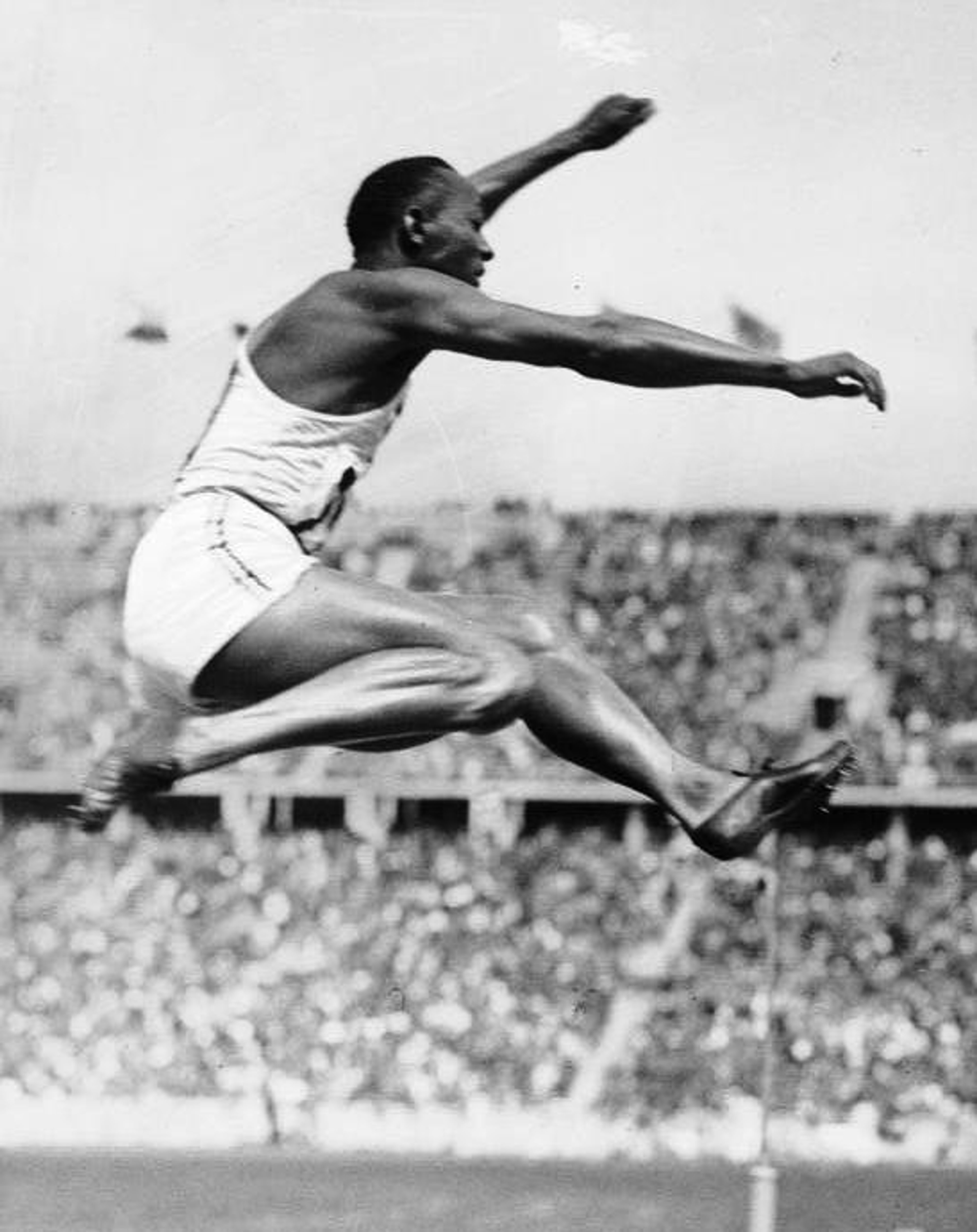
Jesse Owens taking part in the long jump at the 1936 Berlin Olympic Games © Bundesarchiv, Bild 183-R96374 / CC-BY-SA 3.0
Jesse Owens (1913-1980) was one of the greatest American track and field athletes of all time.
In 1935, when competing at the Big Ten Conference Championship in Ann Arbor, Michigan, Owens broke three world records in 1 day.
He also made history at the 1936 Summer Olympic Games in Berlin, Nazi Germany, winning four gold medals for the United States.
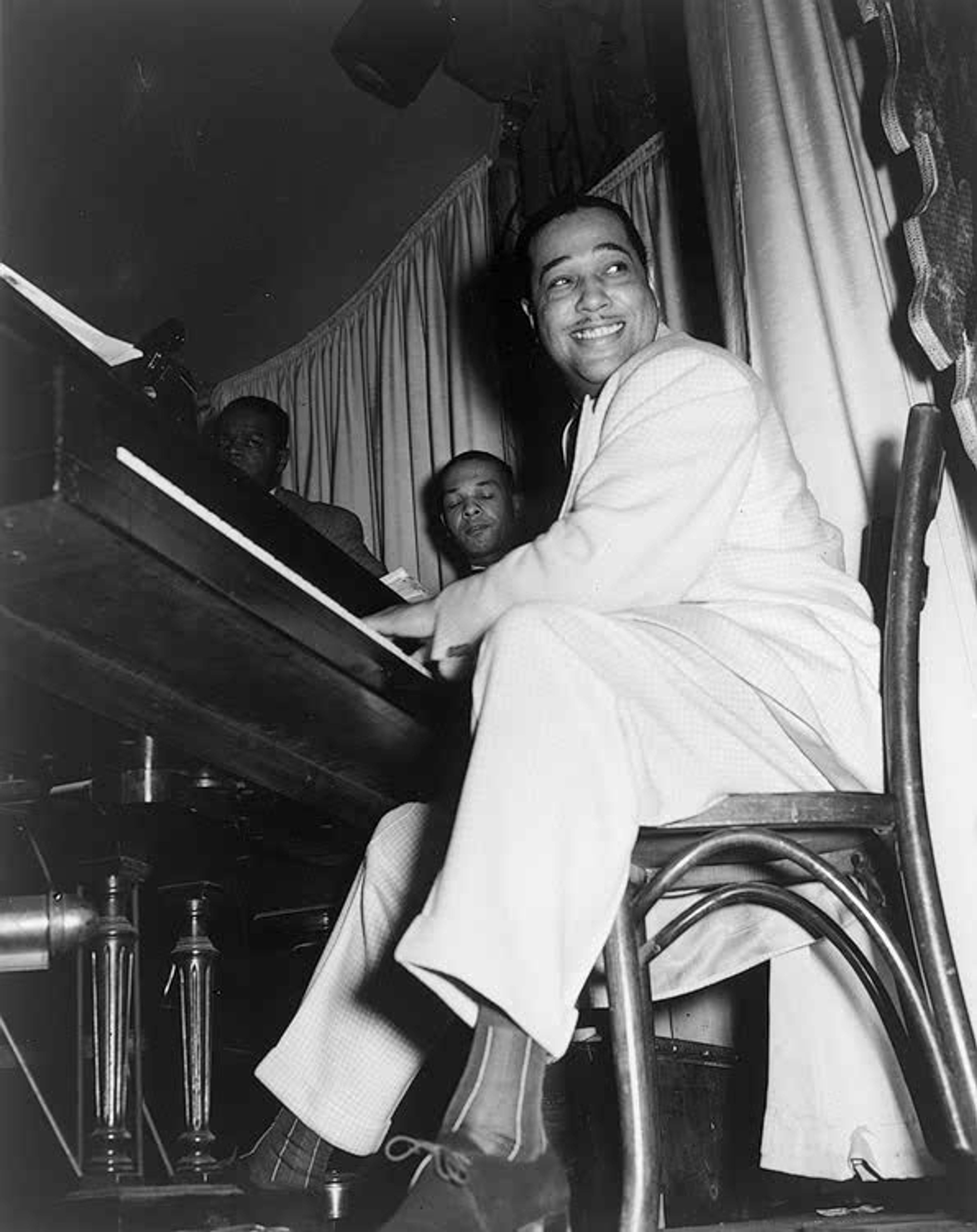
Photo of Duke Ellington at the Hurricane Club, Broadway & W. 51St, New York City, in May 1943. © Gordon Parks. Public Domain, via Wikimedia Commons
Duke Ellington (1899-1974) was an extraordinary jazz musician and composer from Washington, D. C.
He is one of the inventors of big-band jazz and led his band for more than 50 years!
At the time this map was published, he had written 1200 compositions, recorded 1500 songs and sold 20 millions copies.
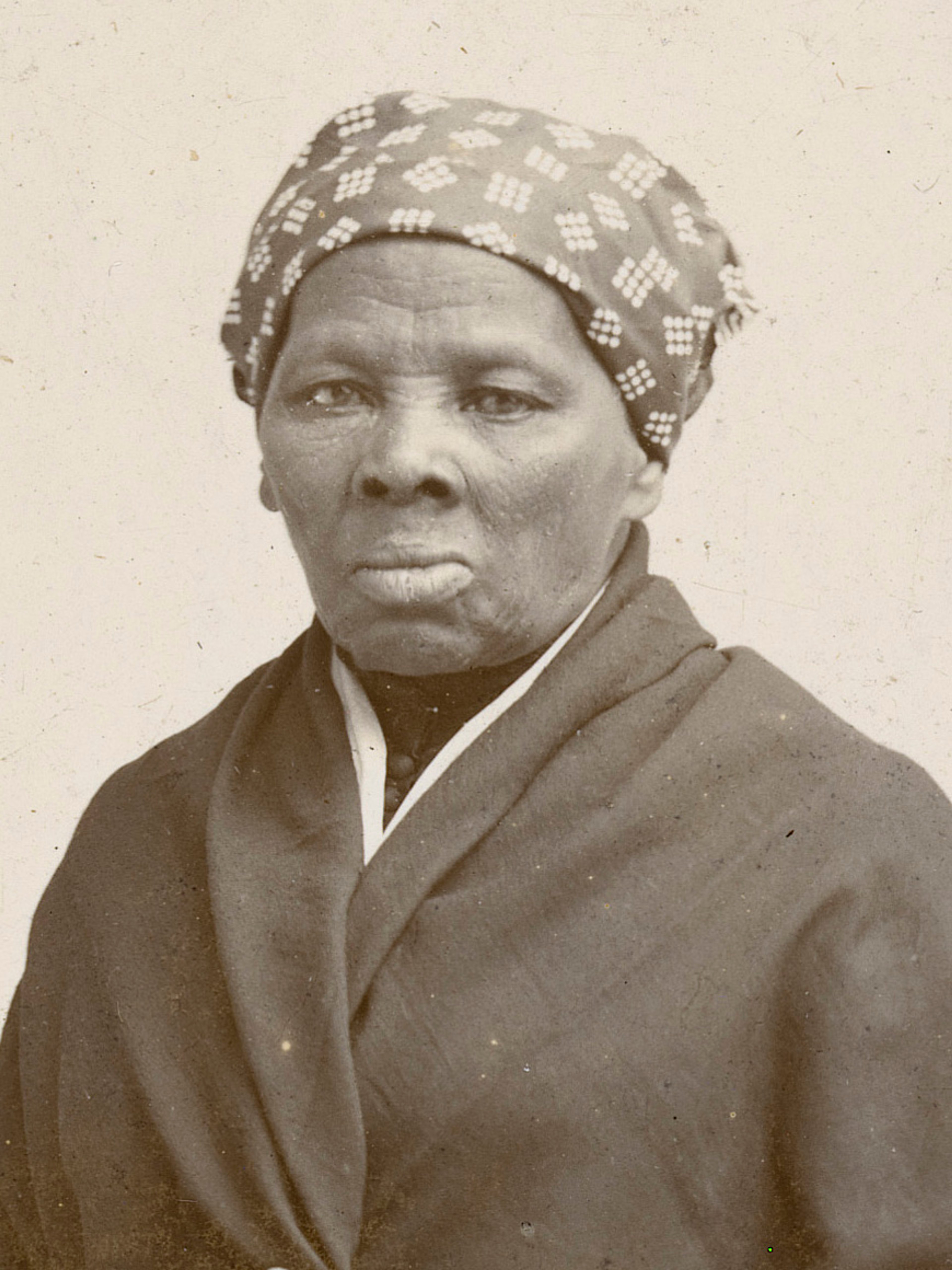
Portrait of Harriet Tubman circa 1885 © Horatio Seymour Squyer - National Portrait Gallery: NPG.2006.86, Public Domain, via Wikimedia Commons
Harriet Tubman (1822-1913) was an abolitionist and activist.
After escaping slavery herself, she became a conductor on the Underground Railroad, a network of secret routes and safe houses established in the 1780s in the northern US and eastern Canada, where she led approximately 70 enslaved people to freedom.
She also worked as a nurse and as a spy for the Union Army during the American Civil War (1861-1865)

Langston Hughes. © Photographed by Carl Van Vechten, 1936, Public domain, via Library of Congress Prints and Photographs Division and Wikimedia Commons
Langston Hughes (1901-1967) was an inspiring poet, playwright, journalist and social activist. He best known as a central figure of the Harlem Renaissance.
In 1926 he published what was considered to be the manifesto of the movement, ‘The Negro Artist and the Racial Mountain’ in The Nation, in which he encourages Black artists and intellectuals to be proud to draw from their own Black culture to inspire their creativity and lifestyle, during a time of segregation and oppression.
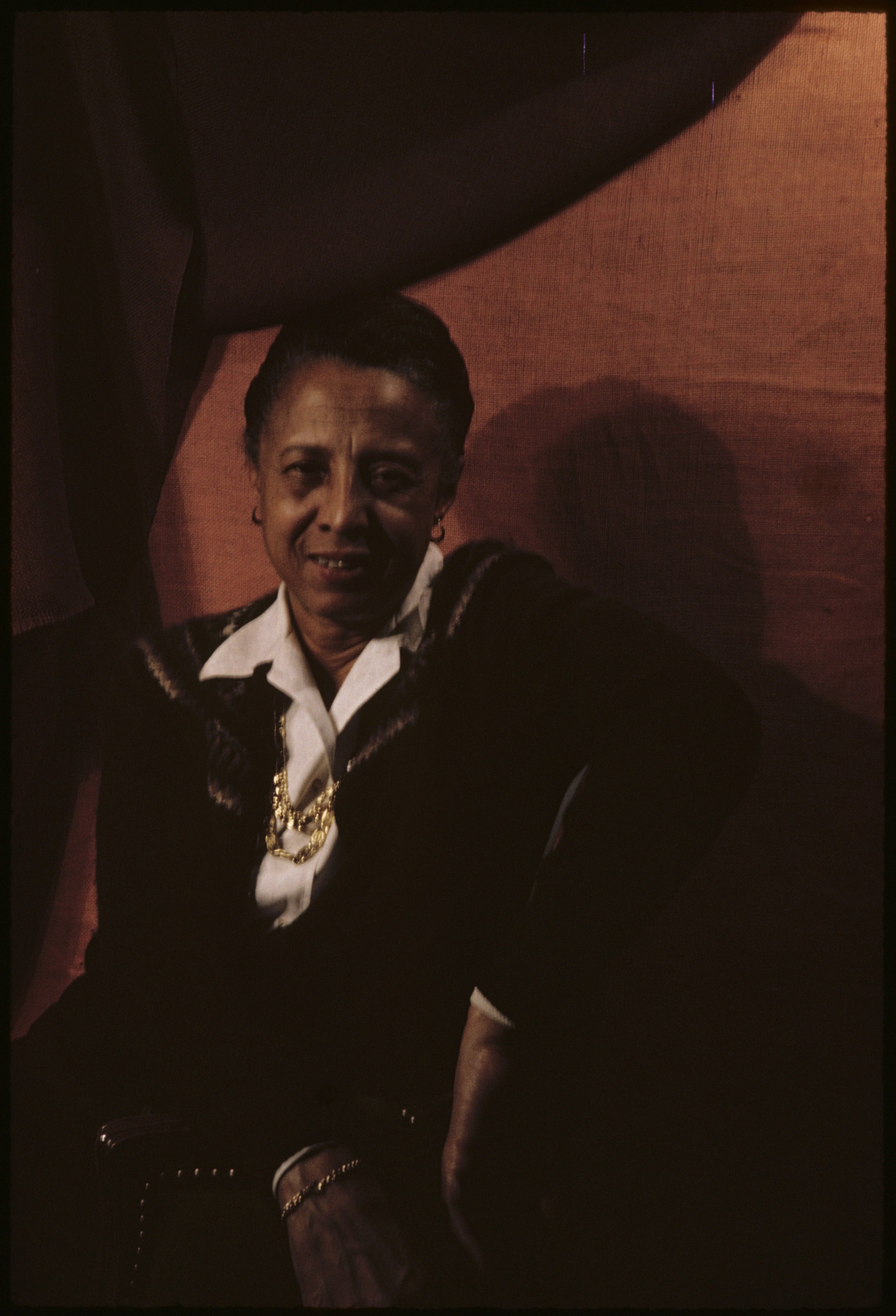
Jefferson was an American artist, photographer, cartographer, and publishing executive. Born in Washington, D. C. at the start of the twentieth century, her father Paul was a calligrapher and engraver for the United States Treasury, and her mother Louise was a musician and singer working on cruise ships on the Potomac River.
As a child, Jefferson was taught how to draw by her father. She went on to pursue an education in the arts in New York City: she attended Howard University to study fine arts, and later studied graphic arts at Hunter College. At this time, Jefferson became one of the founding members of the Harlem Artists Guild, an African-American organisation devoted to supporting and promoting young African-American artists, and creating an inclusive forum to discuss and find solutions for the issues faced by the community.
This coincided with the Harlem Renaissance, an exciting movement between the 1920s and 1940s where African-American talent and identity was celebrated through flourishing creative expression and intellectual discourse.
Portrait of Louise E. Jefferson, 4 February 1964 © Carl Van Vechten. Public access courtesy of the James Weldon Johnson Collection in the Yale Collection of American Literature, Beinecke Rare Book and Manuscript Library. JWJ MSS 1050.
Louise Jefferson started her career as a freelance artist designing posters and book covers for the Young Women’s Christian Association and the Friendship Press, the publishing arm of the National Council of the Churches of Christ in the USA. In 1942, she became the Artistic Director at Friendship Press - breaking the colour barrier and making her one of the first African-Americans to hold a directorial position in a publishing company! She would hold the position until her retirement in 1960.
After a 70-year career in the arts and publishing, Jefferson moved to Litchfield, Connecticut. She ran an art studio where she designed books and made maps on a freelance basis. An avid and admired photographer, she was said to have continued to carry her beloved camera with her, ready to take a photograph ‘on a whim’. Jefferson died at the age of 93.
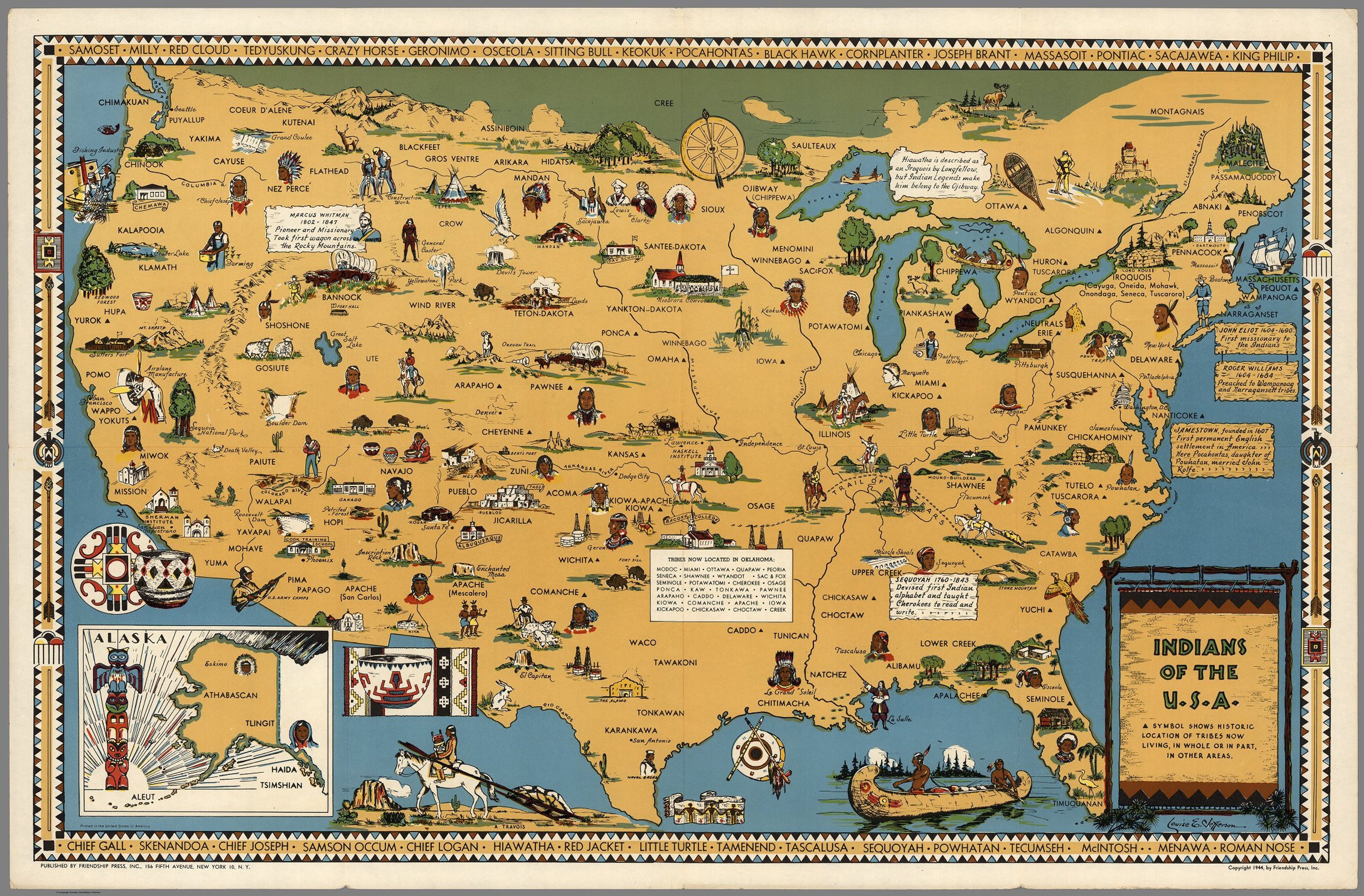
"Indians of the U. S. A." (1944) by Louise E. Jefferson © David Rumsey Map Collection, David Rumsey Map Center, Stanford Libraries. Creative Commons License.
The “Americans on Negro Lineage” map was one of a series of educational pictorial maps, also known as ‘Counter Maps’, created by Jefferson between 1944 and 1956 during her time at the Friendship Press. Just like the former work, these maps were designed to educate, and ultimately activate political and social change. Their pictorial nature meant they were brilliant tools to attract a younger audience.
Here you can see her “Indians of the U. S. A.” map (1944) celebrating and educating the viewer on the history and diversity of Native Americans - with over 100 different tribes! The map also documents the forced removal of Native Americans from their ancestral lands and their relocation to Oklahoma along the "Trail of Tears.”
Additionally, Jefferson's “Uprooted People of the U. S. A.” (1945) describing the multicultural make up of the States through displacements, relocations, population movement, and changes in social conditions. The map is framed by representations of the people affected by these changes following the Second World War.
You can view all of these maps and find out more about the pioneering Louise E. Jefferson in a post by our guest, Iris, on the Library of Congress blog.
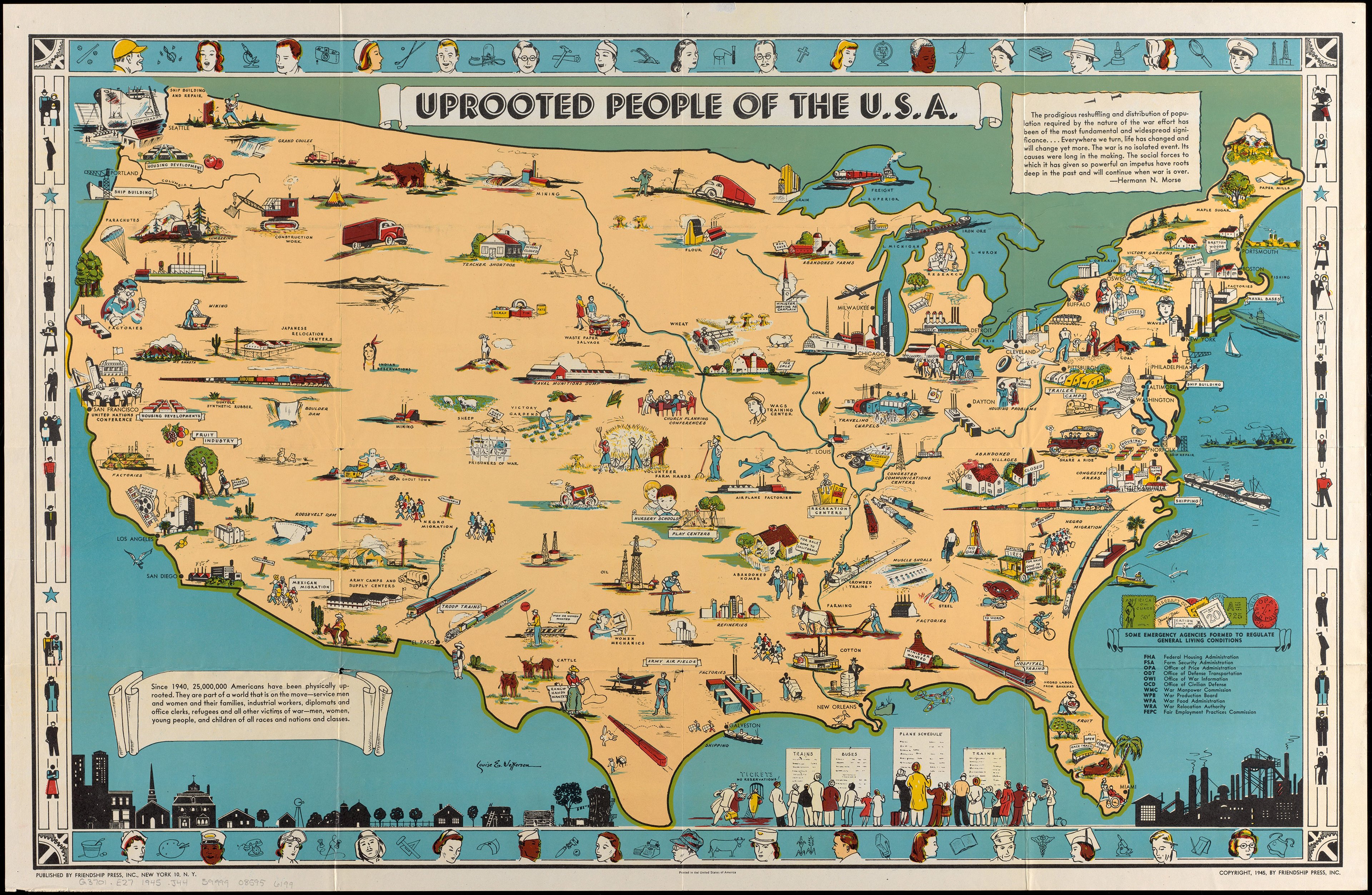
"Uprooted People of the U. S. A." (1945) by Louise E. Jefferson © Map reproduction courtesy of the Norman B. Leventhal Map & Education Center at the Boston Public Library.
With over 50 years experience, Iris now works at the Library of Congress in Washington, D. C. Founded in 1800, it is the world’s largest library with a recorded a total of 171,636,507 items in its collections.. and counting!
The Library's Geography and Map Division is home to 5.6 million maps, making it the world's largest collection of cartographic materials. One of the most famous treasures in the Library’s collection is Martin Waldseemüller's famed 1507 world map, which goes by the nickname of "America’s Birth Certificate" due to it being the first document to name America.
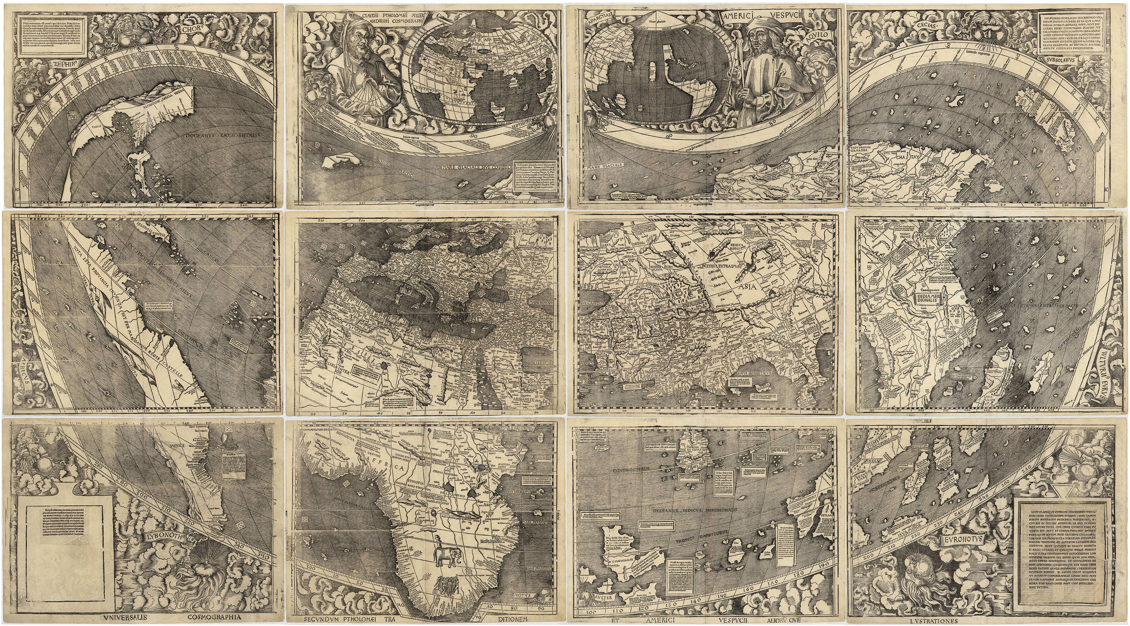
"Universalis Cosmographia", the Waldseemüller wall map dated 1507. © Library of Congress, 2003626426. Public Domain.
Iris’ role has granted her access to some of the world’s most important maps, books and cartographic manuscripts. In the podcast, she shares some of her favourites; one being an atlas of maps made by Major Jedediah Hotchkiss (1828-1899), a topographic engineer in the Confederate Army, drawn during the American Civil War (1861-1865).
Iris describes how exceptional and accurate these maps are for being drawn by hand, and some even drawn on horseback!
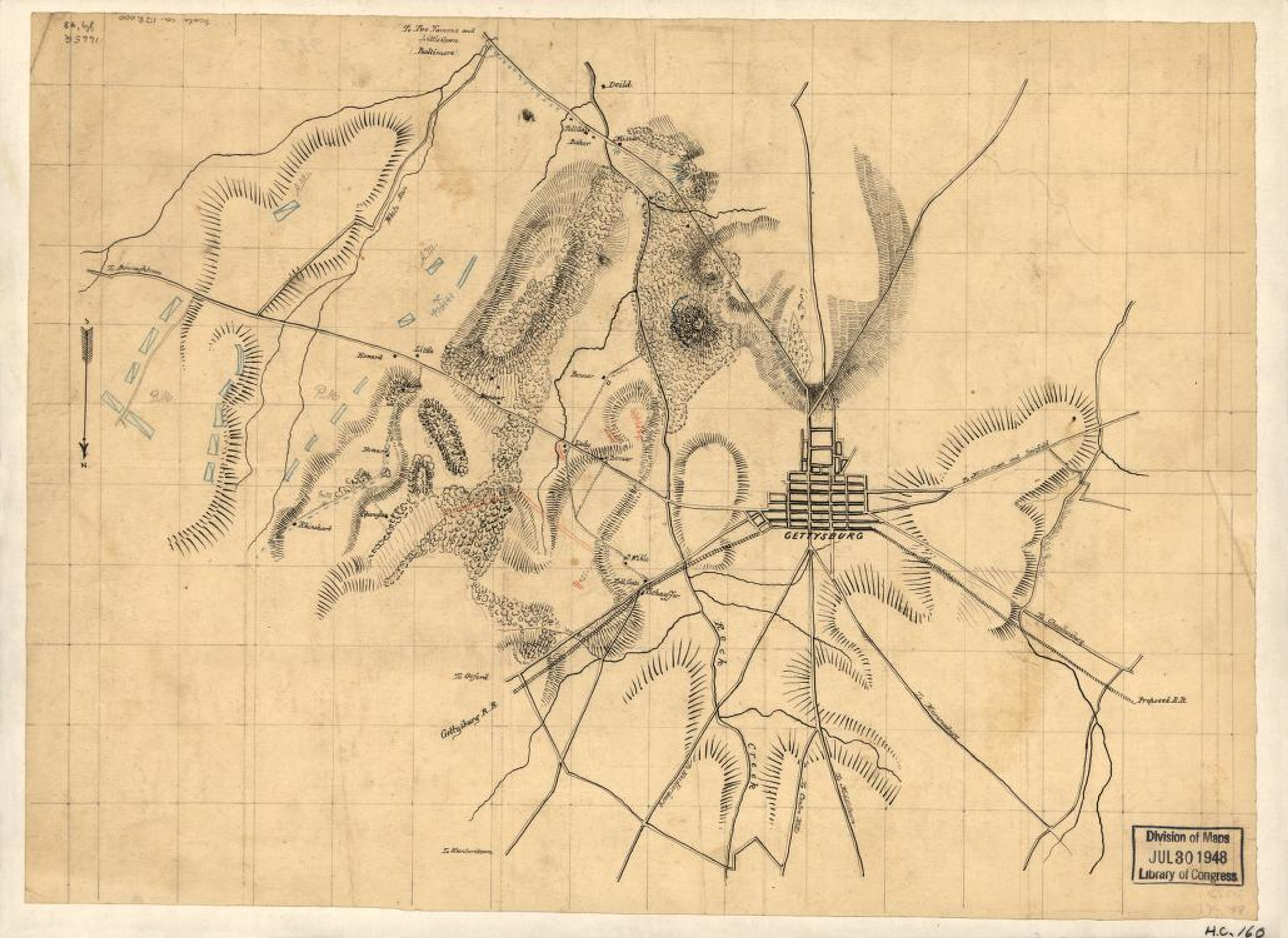
Preliminary sketch of the Battle of Gettysburg showing troop positions, July 2, 1863. By Jed. Hotchkiss. Library of Congress, 2005625067. Public Domain.
The Hotchkiss Collection at the Library contains around 600 maps, 340 of which are manuscript (hand-drawn), mostly covering territory in the states of Virginia and West Virginia. A selection of the maps by Hotchkiss are annotated to show their use during campaign and combat planning by Generals Robert E. Lee and Thomas J. "Stonewall" Jackson. There are also maps that follow Hotchkiss’ post-war work, as well as the development of railroads, mines and settlements in the region.
You can find out more about the Hotchkiss Collection on the Library of Congress website.
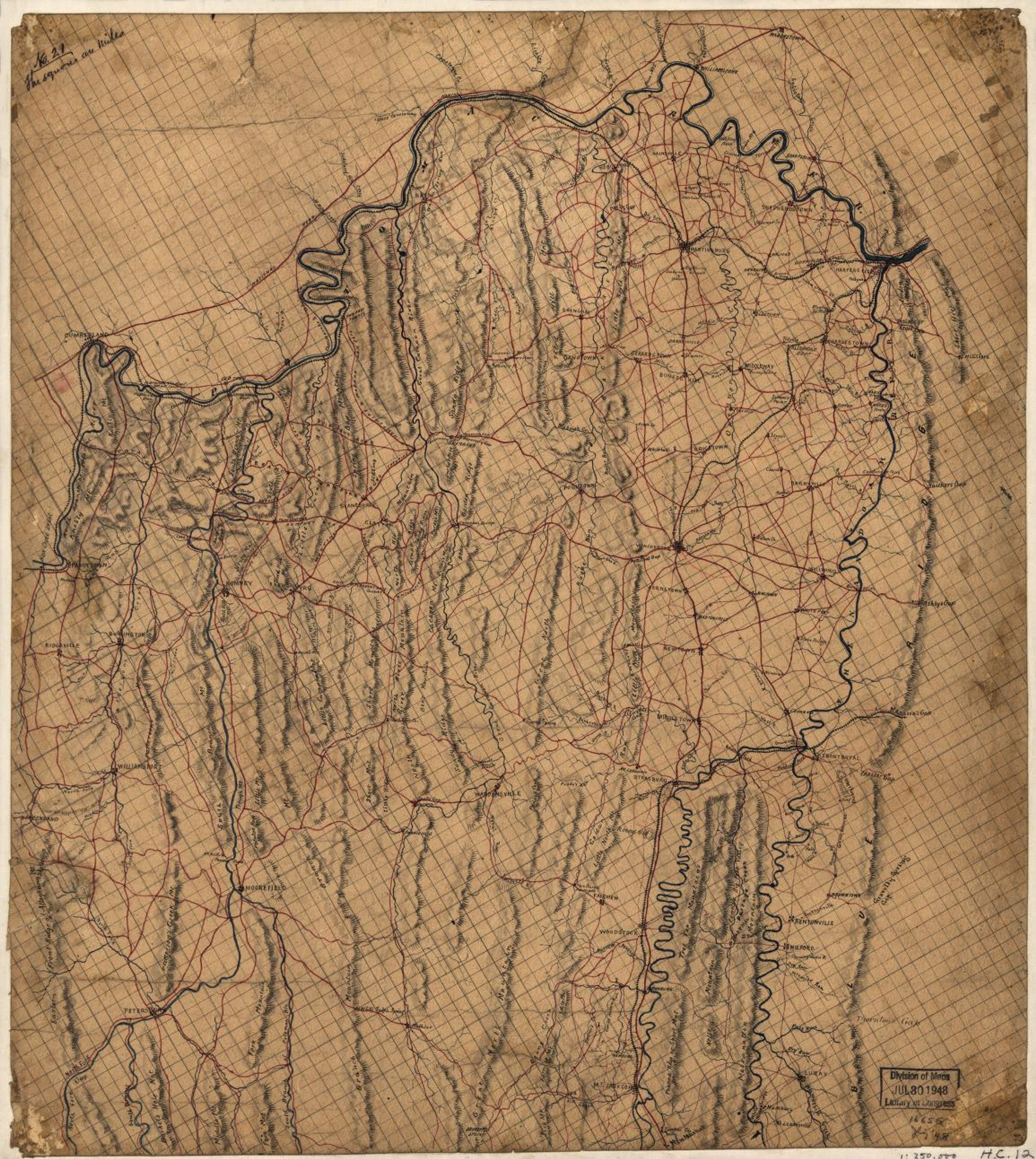
Map of the northern part of Virginia and West Virginia, between the Blue Ridge and the Alleghany Front, south of the Potomac River and north of New Market. [186-, 1860] Map by Jed. Hotchkiss, 2002627435, Library of Congress. Public Domain.
About Iris Taylor

Iris works as Special Assistant to the Director of the Acquisitions and Bibliographic Access Directorate at the Library of Congress.
Her career began at the Richmond Public Library in Virginia and spanned multiple roles in the Richmond Metropolitan Area and the Library of Virginia before joining the Library of Congress in 2002 as a Senior Cataloguing and Metadata Specialist in the Geography and Map Division.
She holds a Bachelor of Science in Criminal Justice from Virginia Commonwealth University and a Master of Library Science from the Catholic University of America, underpinning her distinguished career in libraries.
A committed leader in the field, Iris is active in the American Library Association, including roles as incoming chair of its Map and Geospatial Roundtable, and Councillor-at-Large, and a member of the Associations for Library Collections & Technical Services.
She has also served on the Board of Directors for the Washington Map Society, past district director of District 27 Toastmasters and Executive Board member of the Daniel A.P. Murray African American Cultural Association, where she led the placement of a “Bench By the Road” honouring Daniel Alexander Payne Murray.
In 2022, she received the Honours Award for the Map and Geospatial Roundtable. A graduate of the Library of Congress Leadership Development Program, she also completed a short-term assignment with the White House Library, supporting research and documentation initiatives. She is the author of a 2022 blog on African American cartographer Louise E. Jefferson.
A new episode of WHAT'S YOUR MAP? will be available every two weeks. Why not continue your exploration of the wonderful world of maps by subscribing? That way you'll never miss an episode.
Feel free to let us know - What's YOUR Map?!

