Hannah Claus
Series 4 Episode 2
Encountering the Big River with Hannah Claus
Series 4 Episode 2
Available on all major podcast platforms: click the icons or hit 'play' to listen now.
In this episode, Jerry is joined by Kanien’kehá:ka (Mohawk) and English visual artist, Hannah Claus.
Their meeting takes place at the High Commission of Canada in the UK, where Hannah has an exhibition as part of the its commitment to platform Indigenous Canadian artists. Her evocative body of work is titled 'tsi iotnekahtentiónhatie - éntie nonkwá:ti' [where the waters flow - south shore]. It ells the story of the Kahrhionhwa’kó:wa [the Great River, or Saint Lawrence River].
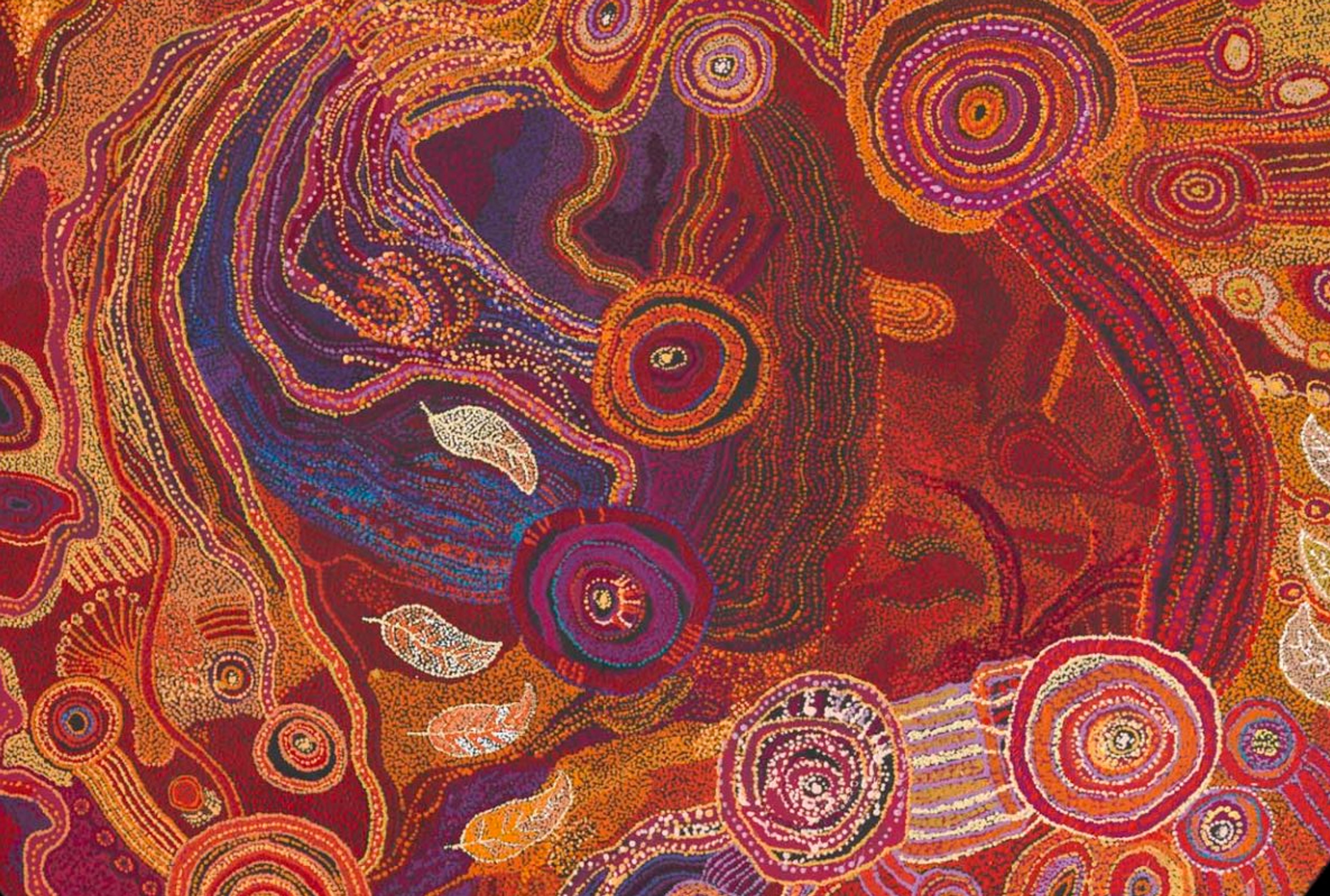
The piece 'éntie nokwá:ti ne Kaniatarowánen' [water song - south shore] features as her chosen map for this episode - a mesmerising, kinetic installation that visualises a sound wave of a water song paying thanks to The Big River, composed by Ionhiarò:roks McComber.
This musical accompaniment was produced especially for Hannah’s body of work, and you can hear a section of this song at the start and end of the episode.
During this intimate tour of Hannah’s artworks, she tells Jerry about First Nations cosmologies and the importance of having a relationship to the land and bodies of water upon which one resides. Together, they delve into the concept of what constitutes a map, and how artists convey the narratives and collective histories of specific places through their work.
To enjoy a larger images of the artwork while you listen, click the image below:

éntie nokwá:ti ne Kaniatarowánen [water song - south shore] (2024). Mixed media. Installation view at the Canada House Gallery in London. ©Hannah Claus
'éntie nokwá:ti ne Kaniatarowánen' [water song - south shore] transcends the familiar European understanding of a map. The artwork is intrinsically linked to the Kahrhionhwa’kó:wa (St. Lawrence River), and more specifically to the area known as Flat Rocks.
Digital imagery of the water, land, and sky taken at Flat Rocks has been printed onto a multitude of light-reflecting acrylic discs that are hung from translucent threads. The artwork undulates through space, tracing the shape of the southern coastline of the river.
Hannah has chosen these materials and the fragility of the artwork so as to immerse the viewer. As people move in the space, the installation freely ebbs and flows like water, and the reflective nature of the discs mimics the rippling caustic effect of light dancing on water. The threads are deliberately visible, in order to illustrate the vital connection that First Nations communities have with the Earth and the sky. They also draw conceptual inspiration from wampum belts, which are mnemonic devices made to narrate history, traditions, responsibilities and laws. These are traditionally made from beads and shells, woven into belts or jewellery.

Eighteenth century wampum belt by an unknown maker, from the Eastern Woodlands area. M1913. Public Domain via McCord Stewart Museum.
As well as providing an insight into her work, Hannah shares her knowledge of the language of the Kanien'kehá:ka - people, whose name means "People of the Flint". This name refers to the power of the people who possess flint to make the fire, and in turn, provide food and warmth to their community and the people they encounter.
Hannah is a member of Kenhtè:ke (Tyendinaga Mohawks of the Bay of Quinte). Woven into her work as both an artist and a teacher are the ancient Haudenosaunee cosmologies and methodologies of the Onkwehon:we [original people]. These highlight a specific way of understanding the world, and their ancestral stories. One integral aspect of Hannah’s practice is her exploration of language, identity, and relationship with the world around her. This is particularly prevalent in the body of work discussed in the current podcast, which explores the interconnected ties that people have with the area surrounding Tiohtià:ke [the Island of Montréal].

Kahrhionhwa'kó:wa [water song] (2024) (detail). ©Hannah Claus
Flat Rocks was once a gathering place for Kahnawakerò:non - a place to socialise and access the water; but since the 1950s and the construction of the St. Lawrence Seaway - a large commercial shipping route - access to the river has been made increasingly less accessible or cut the community off entirely. Throughout history, Kahrhionhwa’kó:wa (St. Lawrence River), which in Kanien'kehá:ka means ‘big river’, has been the lifeblood of the country - a means of food, transport, and livelihood.
From birth, Kanien’kehá:ka people travelled across the continent, learning the importance of trading and communication, using the stars and rivers to create their own means of navigation, and passing this knowledge down through aural or embodied practices. As Hannah explains, travel and trade was not just about transactions: it was also about ceremony and strong relationships.

Map of the St. Lawrence River region. ©Farah Jemel and Allen Cruz-Jimenez
This modern map - commissioned by curator Lori Beavis to accompany Hannah's exhibition - locates the four Kanien’kehá:ka communities in purple: Kanehsatà:ke, Kahnawà:ke, Kenhtèke | Tyendinaga, and Ohshwé:ken. A fifth community, Ahkwesàhsne, straddles the border with the U.S.A.. Major cities are marked in red, using their European names.
For an understanding of the location of Flat Rocks and its relation to Tiohtià:ke [Montréal], you can visit the important resource MohawkAtlas.org. A detailed listing of Indigenous place-names with their translations can also be found on the Decolonial Atlas.
Centuries of colonial imposition and the development of the St. Lawrence Seaway has marginalised the Kanien’kehà:ka. This land was expropriated in 1534 following the arrival of French settlers. Like many European nations of the time, they were in search of maritime passage to Asia that avoided existing trade routes to the east - namely those of the Portuguese and Spanish Empires. They were in pursuit of gold, spices, and other riches that could be transported back to France.

Portrait of Jacques Cartier by Francois Riss (1839). Public Domain via World History Encyclopedia.
In the hope of finding a northwest passage to Asia, the French employed Jacques Cartier (c.1491-1557), a Breton navigator, to captain an expedition.
During three maritime voyages between 1534-42, Cartier explored the St. Lawrence River, claiming the territory he encountered for the French nation and taking hostages along his route. He is credited as the first European to map the shores of the River, and naming the territory ‘Canada’ - using the Kanien'kehá:ka name for ‘settlement’, Kaná:ta.
You can find out more about Cartier here.

One of the earliest European maps to depict ‘Canada’ is Gregor Ruysch’s world map (1507). ©The Sunderland Collection
Hannah tells Jerry that her role as an artist is to encourage people to engage with the work by creating universal access, and offering deeper layers for people to learn and take meaning from. She shares that maps have influenced her work but through her recognition of their distortion of territories and perceived ‘truth’, she presents a way of looking at the world that better reflects the ancestral histories of the Kanien'kehá:ka and the world she personally recognises.
Hannah and Lori are co-founders of the not-for-profit arts centre, daphne. A creative network and studio makes a space for contemporary Indigenous artists and creators, and is the first of its kind in Tiohtià:ke. Find out more here.

Jerry and Hannah at Canada House Gallery with her artworks water song [Kahrhionhwa'kó:wa] (2024) and Landscape of the Land (2024).
The exhibition 'tsi iotnekahtentiónhatie - éntie nonkwá:ti' [where the waters flow - south shore] runs until 24 January 2026.
Oculi Mundi and Whistledown Studios would also like to extend sincere thanks to the High Commission of Canada in the UK - in particular Simon Anderson, Caitlin Workman, and the Public Programming Team - for the invitation to connect and the support they have provided for this special episode of What's Your Map?
About Hannah Claus

©Elias Touil
Hannah Claus (member of Kenhtè:ke / Tyendinaga Mohawks of the Bay of Quinte) is a Kanien’kehá:ka and English visual artist who engages Onkwehon:we epistemology to highlight ways of understanding and being in relation with the world.
She attended Ontario College of Art and Design in Tkaronto [Toronto] (1997) and her Master of Fine Arts from Concordia University in Tiohtià:ke [Montreal] (2004). She is a 2019 Eiteljorg Fellow and 2020 recipient of the Prix Giverny, recent exhibitions include Contextile: Biennial of Contemporary Textile Art (Guimarães, Portugal), Ascending Horizons (McMaster Art Museum, Hamilton Ontario) and the North American touring exhibition, Radical Stitch.
Claus’ work is held in public collections, including the National Gallery of Canada, the Eiteljorg Museum, North American Native Museum (Zurich, CH), the Montreal Museum of Fine Arts and the City of Montreal.
Concurrent with her studio practice, Claus is an Associate Professor in the Department of Studio Arts at Concordia University and holds a Concordia University Research Chair in Onkwehonwené:ha (New Scholar).
She is currently Co-Director of the Indigenous Futures Research Centre at Concordia University and is one of the co-founders of daphne, the Indigenous-led artist-run centre based in Tiohtià:ke.
Why not continue your exploration of the wonderful world of maps by subscribing to the podcast? That way you will never miss an episode.
Feel free to let us know - What's YOUR Map?!