Ed Parsons
Series 2 Episode 1
Wherefore the Map? with Ed Parsons
Series 2 Episode 1
Available on all major podcast platforms: click on the icons below or on 'play' to listen now.
Welcome to What’s Your Map? In this episode, Ed Parsons, digital geographer and geospatial wizard at Google, traces the history of digital mapping. He leads Jerry from its roots in Gerard Mercator's iconic map projection, to the Google Maps we use today - and beyond...
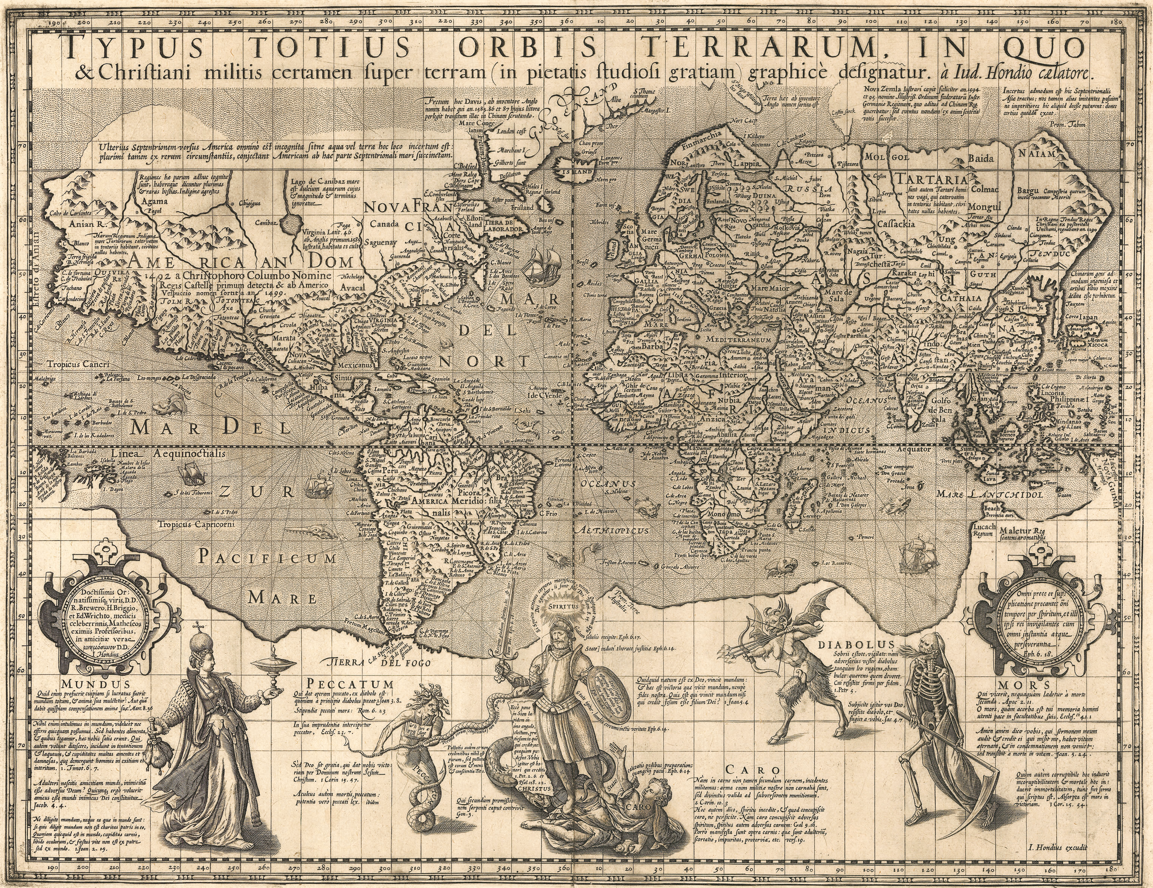
Ed's chosen map is the 'Christian Knight Map', produced in Amsterdam by Jodocus Hondius in 1597. It is the first map to use Mercator's Projection after the death of its inventor, Gerard Mercator (1512-1594). This projection was hugely influential because it changed the way maps were drawn - but the Christian Knight map is also significant for another reason: it is a great example of maps that were created as propaganda.
Together, Ed and Jerry tease out why maps are made, and what purposes they serve. Who is each map meant for, and what does that mean? A Protestant map in 16th century Europe could be a rallying cry for a Monarch; and a digital road map in the 20th century could transform how journeys are conceived of, and taken. But will maps always be needed - and are humans always the target audience?
Tune in to find out! And, to zoom in to a high-definition image of the map during the podcast, click on the image below:
Jodocus Hondius's 'Christian Knight' Map

As well as being an exquisite example of master engraver and mapmaker Jodocus Hondius’ work, it is a fascinating document that operates as a piece of Royal propaganda, simultaneously illustrating developments in cartography.
In the fore of the map, there are powerful depictions of the philosophical allegories; the Christian Knight and the King fighting the Rulers of Darkness: Vanity, Sin, Carnal Weakness, the Devil and Death. This imagery was taken from a rare broadside print of an illustration by Maerten de Vos titled, “The Christian Soldier’s Spiritual Struggle”, here engraved by Hieronymous Wierix and published by Gerard de Jode, 1580.


"Henri IV, roi de France et de Navarre (1553-1610)". School of Frans Pourbus the Younger, Public domain, via Wikimedia Commons.
This compelling visual shows the battle between good and evil, and is purported to be a portrait of French King, Henry IV (1553-1610).
There had been a religious crisis in Europe between Protestants (Huguenot) and Roman Catholics, resulting in The French Wars of Religion (1562-1598). Henry IV had been raised as a Protestant and even distinguished himself in battle fighting against the Catholic forces, but following his appointment as King in 1572, he struggled to keep hold of his Kingdom. After much hesitation, he converted to Catholicism in 1593 in order to reunify France and consolidate his power. Spain, under King Philip II, had however continued to support the remaining resistance to him in France, creating a further period of bloodshed and upheaval.
A peace agreement was finally reached, and the Edict of Nantes was signed in April 1598, declaring Roman Catholicism as the state church, but granting religious freedoms to Protestants. This served as one of the first decrees of religious tolerance in Europe.
Hondius had chosen to show the geography of the world using a map projection by legendary mapmaker Gerard Mercator that was first published in 1569, but up until this point was not particularly popular.
The Mercator Projection is regarded as one of the great intellectual inventions of cartography, solving the ancient problem of how to map the spherical Earth onto a flat plane. You can find out more about this and other Map Projections in the Stories section of Oculi Mundi.
Because the Mercator Projection was the most practical projection to navigate by, it became the standard for hundreds of years. However, towards the mid 20th century, it became unpopular due to the geographical distortions it created and Imperialistic connotations they alluded to - although as Ed suggests, this was unlikely to be the ambition of mapmaker, Mercator!
The Mercator Projection was also the chosen for transposing an analogue paper map into a digital map.

Photo by Mika Baumeister on Unsplash
In 1993, a World Atlas was produced to accompany Mircosoft's CD-ROM multimedia encyclopaedia, Encarta. This exciting tool offered a brand new way to experience maps and learn about our World. Encarta eventually ran its course, losing out to rise of the Internet and interactive mapping applications like mapquest (established in 1996).
A new breed of online mapping and geospatial technology arrived on our screens; Google Maps (2005) and Google Earth (2006/7) used interactive map tiles of satellite imagery and aerial photography to create a 3D representation of our World, superimposed with astonishing amounts of information. It was a game-changer for navigation and quickly evolved to be populated with real-time data added by anonymous users around the globe.
So, what does the future hold for the map? Will we still call them 'maps'? Will advances in technology, and the use of augmented reality and AI mean that journey planning is automated by machines? We will just have to wait and see...
About Ed Parsons


Image courtesy of Ed Parsons
Ed Parsons is a Digital Geographer, Keynote Speaker, and Google’s Open Data Lead. For nearly two decades, Ed was Google’s Geospatial Technologist, with responsibility for evangelising Google’s mission to organise the world’s information using Geography. In this role he maintains links with Governments, Universities, Research and Standards Organisations which are involved in the development of Geospatial Technology. Ed also leads Google’s efforts in maintaining a healthy Open Data Ecosystem in Europe.
Ed has an extraordinary amount of experience in digital mapping and location-based data; he is a member of the Board of Directors of the Open Geospatial Consortium and was co-chair of the W3C/OGC Spatial Data on the Web Working Group. He also represents Google at the EMTEL committee of ETSI developing geospatial solutions for emergency telecommunications.
He is a Visiting Professor at University College London and has been an industry advisor to a number of international universities.
Ed is based in Google’s London office, and anywhere else he can plug in his laptop.

Ed was the first Chief Technology Officer in the 200-year-old history of Ordnance Survey, and was instrumental in moving the focus of the organisation from mapping to Geographical Information. He came to the Ordnance Survey from Autodesk, where he was EMEA Applications Manager for the Geographical Information Systems (GIS) Division.
He earned a Masters degree in Applied Remote Sensing from Cranfield Institute of Technology, holds a Honorary Doctorate in Science from Kingston University, London. and is a fellow of both the Royal Geographical Society, and the Royal Institute of Navigation.
In 2024 Ed was awarded the inaugural “Professional Geography Award” for excellence in the use of geography in professional practice by the Royal Geographical Society.
In October 2024, Ed took part in The Sunderland Collection Symposium “Maps Are Too Exciting! Digital Innovation in Mapping”, in association with Bodleian Libraries and the ARCHIOx Project. He participated in a panel discussion on “Mapping in a Digital World”, delivering a fascinating talk, “Is That the World in Your Pocket?”.
A new episode of WHAT'S YOUR MAP? will be available every two weeks. Why not continue your exploration of the wonderful world of maps by subscribing? That way you'll never miss an episode.
Feel free to let us know - What's YOUR Map?!

