David Barrie
Series 5 Episode 7
Sea Queens and Desert Ants: Celestial Navigation with David Barrie
Series 5 Episode 7
Available on all major podcast platforms: click the icons or hit 'play' to listen now.
In this episode, Jerry meets master navigator, sailing expert and award-winning author David Barrie. Together, they discuss a British Admiralty chart of the North Atlantic Ocean that tracks David’s incredible 1973 Transatlantic voyage aboard a 35-foot yacht named Sæcwen, from Halifax in Nova Scotia east across the Ocean to Falmouth in Cornwall, UK.
We learn about David’s fascination with celestial navigation and an optical instrument called a sextant that he and his fellow crew mates used during the 24-day adventure to find their positions at sea. A sextant is an extraordinary tool that identifies the angle between the horizon and a celestial body - such as the Sun, the Moon or a star - to assist in the determining of latitude and longitude at sea.
During the episode, we also hear about David's transition from the field of experimental psychology to his exploration of animal behaviour and wayfinding, and a glimpse into the world of supernavigators.

David’s sea chart of the North Atlantic Ocean. Image courtesy of David Barrie.
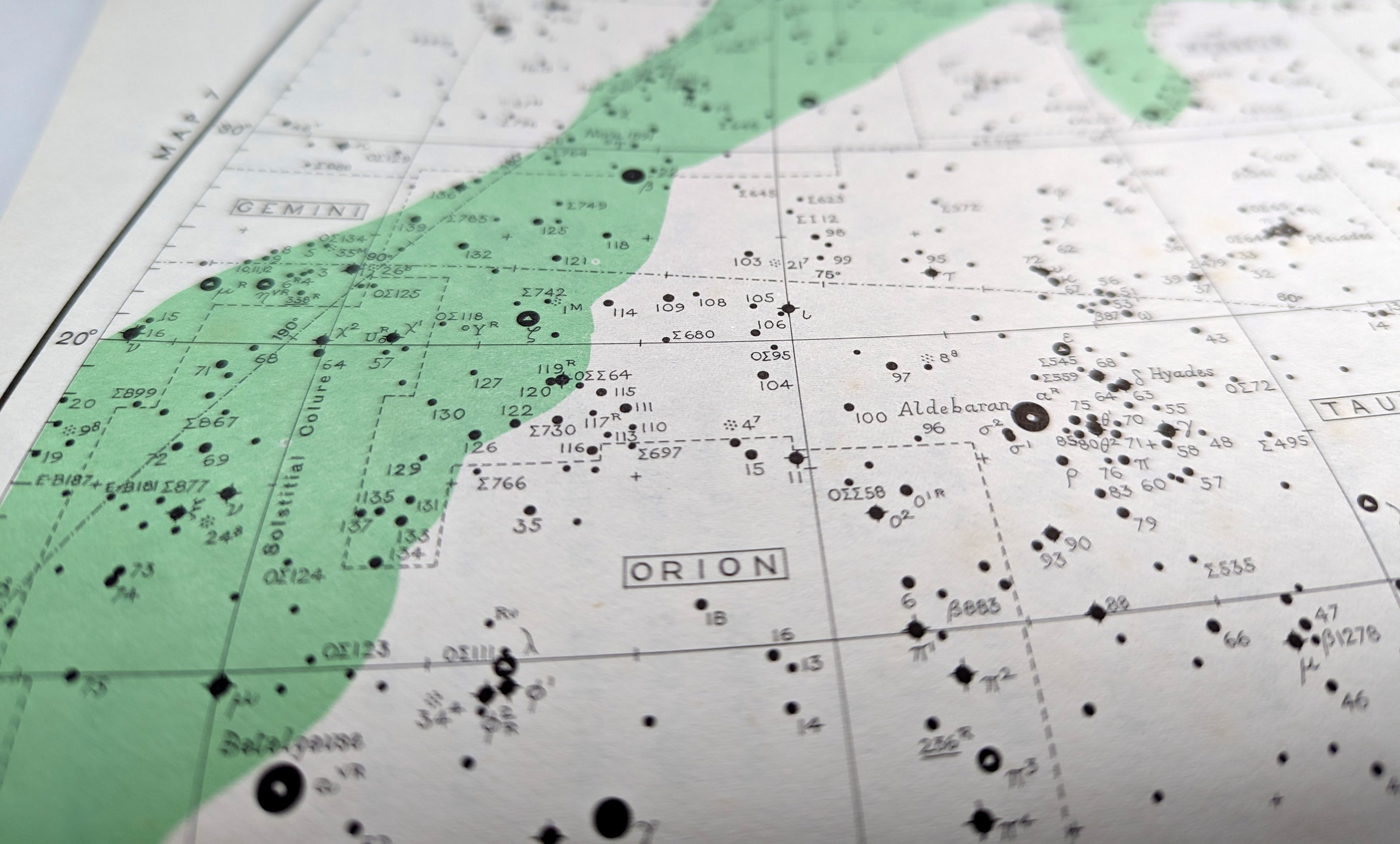
David’s chosen map is a sea chart of the North Atlantic Ocean. It covers a vast expanse of territory - extending from the Hudson Strait and Labrador in North-western Canada to Northern Florida and Bermuda in the the west, and in the east it shows the Faroe Islands, North-western Europe, northern Africa and the Azores. The majority of the chart is ocean.
It was published by the British Admiralty. Established in 1707, the Admiralty historically commanded the Royal Navy, and was a governmental department responsible for upholding maritime law and producing sea charts. It was integrated into the Ministry of Defence in 1964 and continues today as the UK Hydrographic Office, producing global navigational sea charts - although now, they are primarily digital and not printed paper maps.
This map highlights land in grey, uses a pale blue to show shallow water, leaves deep water uncoloured. Across the map there are lines of latitude, longitude as well as a multitude of markings and instructional devices.

Wood engraving showing sailors using sounding lines to meaure the depth of the ocean. From ‘La Marine’ by Eugène Pacini (1844) Public Domain
The many numbered points on the map are known as soundings - labelled ocean depths at specific locations which illustrate the topography of the sea floor. Very important for sea faring vessels, soundings are measured in fathoms which are equal to six feet.
As David tells Jerry, soundings would have been calculated by dropping a heavy lead weight over the side of a ship attached to a measured length of rope or steel wire - a technique dating back hundreds of years!
In the episode, David shares with Jerry his love of celestial navigation, admitting that he is ‘completely entranced’. This was a skill he learnt and his crew relied upon during their 1973 voyage on their yacht - the Sæcwen, an Anglo-Saxon name meaning ‘Sea Queen’. Transatlantic crossings in yachts like this are fairly routine now but even fifty years ago were very unusual.
Their journey started in Portland, Maine on the East Coast of the United States, from there they travelled to Halifax in Nova Scotia and then set off east across the Atlantic. They landed at their final destination in Falmouth, Cornwall in the United Kingdom. The pencilled cross markers visible on the sea chart denote the ship’s daily noon positions during the 24-day crossing, a measurement calculated using a sextant.

Detail of David’s map showing the start of his journey. Image courtesy of David Barrie.

Sextant 'Vandervoodt' (c1875) © Collectie Stad Antwerpen, MAS
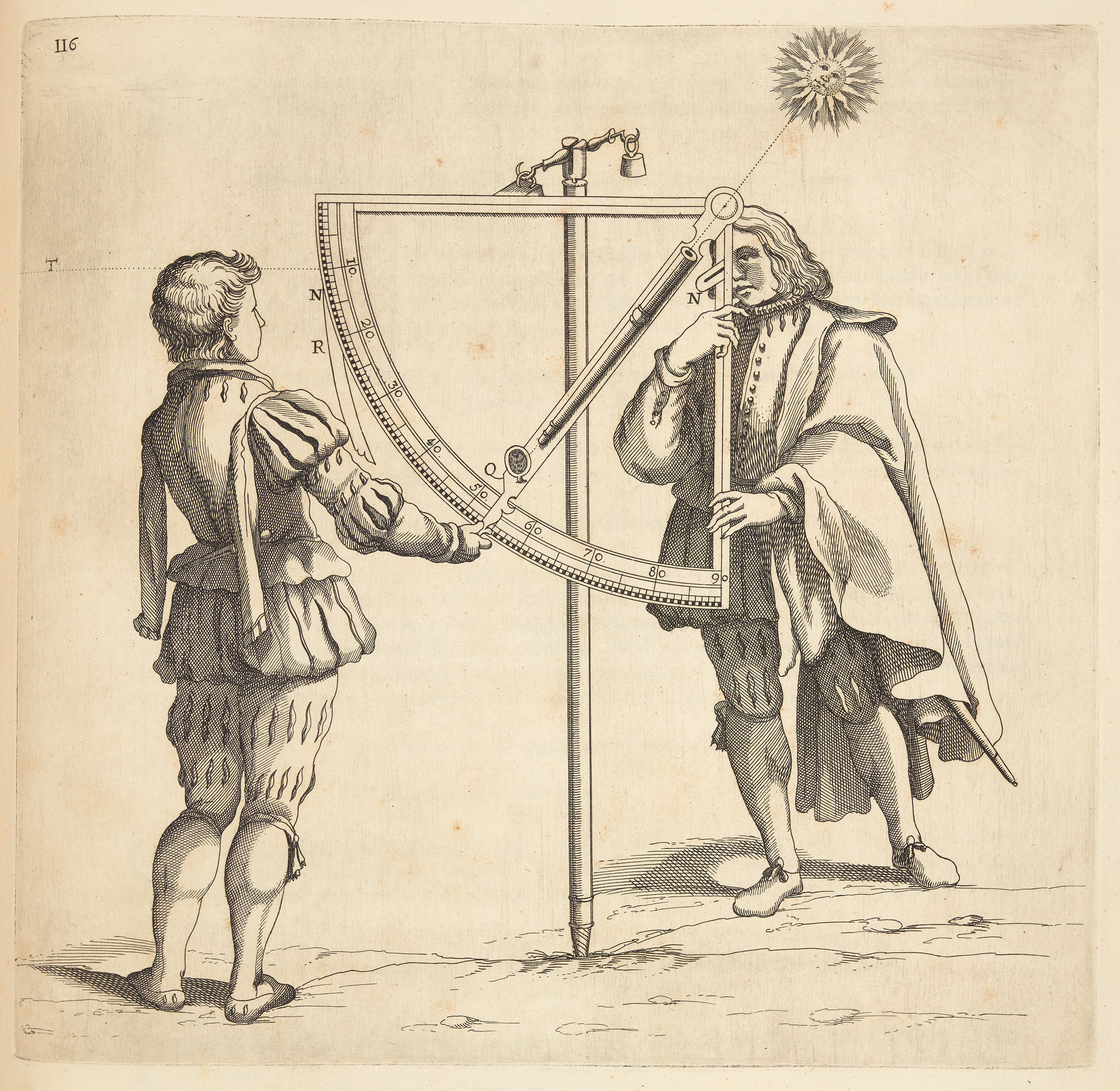
Illustration of a quadrant from Robert Dudley’s Dell’Arcano del Mare (1647) ©The Sunderland Collection.
The sextant is an optical instrument designed for measuring angles. It which emerged in the 1750s as an evolution of English mathematician John Hadley’s octant (1730). These tools ultimately derive from a 1699 mathematical concept and double-reflecting instrument created by Sir Isaac Newton.
By measuring the angle between a celestial body - such as the Moon, the Sun, or a star - and the horizon, the device enables mariners to determine their latitude and longitude at sea. Its name is rooted in the Latin word sextus, meaning ‘one-sixth’, reflecting its 60° arc.
This 1973 adventure and David’s passion for the history of this scientific instrument served as the inspiration for his debut book, Sextant. The work is a personal memoir of his Transatlantic passage, woven together with the histories of Europe’s most renowned navigators and explorers.

Oil painting of John Harrison by Thomas King (c1767)

© Science Museum Group Collection
Jerry and David’s conversation turned to another monumental maritime breakthrough: John Harrison’s marine chronometer. This invention addressed the critical ‘longitude problem’ by allowing navigators to keep accurate time while at sea.
Harrison (1693-1776), a self-taught clockmaker and skilled carpenter, had previously developed precise longcase or ‘grandfather’ clocks in the 1720s before turning his attention to a more portable seafaring solution. His marine clock was revolutionary and surpassed the capabilities of other contemporary timepieces.
The Harrison clocks represented a ground-breaking shift in maritime technology, empowering sailors to calculate longitude while at sea. These instruments were the culmination of Harrison's lifelong dedication, marking significant achievements not only in the evolution of horology but also in the fields of navigation and cartography. Find out more here.

The figure-eight ‘waggle dance’ of the honeybee. J. Tautz and M. Kleinhenz, Beegroup Würzburg for L. Chittka’s ‘Dances as Windows into Insect Perception.’ (2004) CC BY 2.5
As a student, David studied experimental psychology which is where he learnt about the expert navigation skills of honey bees. More specifically, his interest in the work of Karl von Frisch’s 1967 study of how honey bees trace and communicate the location of food sources to their hives to their colony.
Von Frisch famously discovered that bees use two distinct ‘dances’ - the round dance and the waggle dance - to share the exact distance and direction of nectar and pollen to their fellow bees.

Sahara Desert Ant (Cataglyphus fortis) © antweb.org
David also discusses the Sahara Desert Ant (Cataglyphus fortis), a upsernavigator of the natural world, and his admiration for the work of German zoologist Rüdiger Wehner.
Wehner identified that these ants use ‘dead reckoning’ - a process which involves estimating one's current position by tracking speed, direction, and time to navigate. His research reveals that a specific section of the Desert Ant's eye have evolved to detect polarised light patterns in the sky created by the Sun. By using these patterns alongside an internal time-compensated sun compass, the ants are able to maintain a consistent course.
Additionally, David explains that these ants essentially possess natural pedometers, counting their steps to measure distance. He notes to Jerry that this remarkable ability to navigate is prevalent in most insects and many species of birds and animals.

Detail from Petrus Apianus’s Cosmographia (1541) showing celestial measurement techniques © The Sunderland Collection
About David Barrie

David is an experienced sailor and navigator. He has worked as a deckhand onboard ship and has made many long voyages under sail, starting with the trans-Atlantic passage that inspired the writing of his first book Sextant -shortlisted for the Mountbatten Literary Award.
His second, Incredible Journeys (Supernavigators in North America) was The Sunday Times Nature Book of the Year and won the Gold Nautilus Book Award. A version of Supernavigators adapted for young people was published in 2025.
David studied experimental psychology and philosophy at Oxford University, where he first became interested in the study of animal behaviour.
Having joined the British Diplomatic Service, he served at the British Embassy in Dublin and was later involved in the negotiations that led to the Anglo-Irish Agreement of 1985. After leaving government service he worked for many years in the arts - first as director of the UK-wide Japan Festival 1991, and then as director of the charity, the Art Fund.
He is a Fellow of the Royal Institute of Navigation and the Linnean Society of London, and was awarded a CBE in 2010.
David was a series consultant for the National Geographic mini-series, Incredible Animal Journeys (2023) and is now working on his first novel.
The great-great-nephew of the playwright, J. M. Barrie, David is married with two daughters and lives in London.

Map of the coast of Cornwall including Falmouth, from Lucasz Waghenaer’s ‘Mariner’s Mirror’ (1586)
Why not continue your exploration of the wonderful world of maps by subscribing to the podcast? That way you will never miss an episode.
Feel free to let us know - What's YOUR Map?!
All views and opinions expressed by guests on the podcast are entirely their own and do not represent those of The Sunderland Collection or Whistledown Productions.