Sathnam Sanghera
Series 2 Episode 2
Lines that Divide: The Melancholy of Colonial Mapping with Sathnam Sanghera
Series 2 Episode 2
Available on all major podcast platforms: click on the icons below or on 'play' to listen now.
Welcome to What’s Your Map? In this episode, Jerry meets journalist and best-selling author Sathnam Sanghera, to discuss the vast impact of a single line on a map.
Sundering families, communities, and religions, and leading to horrific loss of life and displacement, the Partition of India in 1947 sent shockwaves through Southeast Asia and has been described as the "central historic event" in the region's recent history.
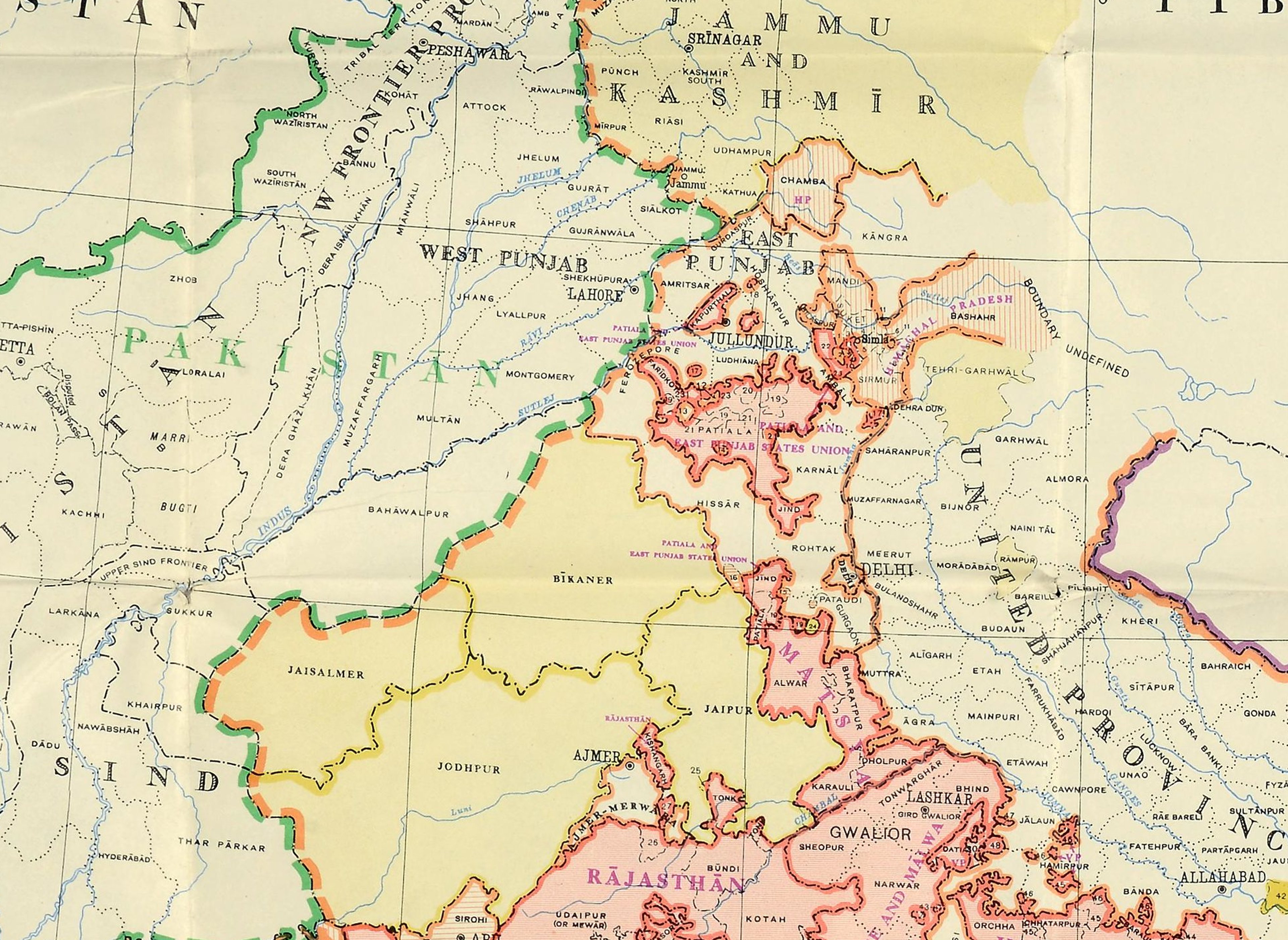
Sathnam examines a map of the Partition from the UK National Archives, drawn in 1948. He and Jerry discuss the impact on identity, religion and the freedom to travel, among other aspects of daily life that changed forever for millions of people - including Sathnam's Sikh family. They also reflect on what the map does not show, such as the nuances of communities and belief systems, flowing under the borders that it imposes.
To zoom in to a high-definition image of the map during the podcast, click on the image below:
Image credit to The National Archives. 1948 Post-Partition Map of India - India's Plan for Uniting and Merging Indian States, 1948. Catalogue Ref: DO 142/484 (1). This map was in the appendix of the white paper which was tabled in the Parliament of India on 15 March 1950 (Ref: Parliamentary Debates, Part II, Volume III, 1950, p. 1569). This is the official record of the merger of more than five hundred princely state, which had become independent after the lapse of Paramountcy of the British Crown.
Shortly after the Second World War, Britain realised that they could not afford to maintain their control over India. Following riots by Indian nationalists calling for independence during the summer of 1946, the British Government made plans to withdraw as soon as they were able in order to avoid civil war, announcing their departure date from India by July 1948.

Lord Mountbatten (centre) meets First Prime Minister of Independent India Jawaharlal Nehru (left), First Governor General of Pakistan Muhammed Ali Jinnah and other Leaders to plan Partition of India, 1947. Credit: Unknown author, Public domain, via Wikimedia Commons

Newspaper clipping "How India May Be Split Up" from The Daily Herald, 4 June 1947. Map speculating on a possible division of India. The term partition of India usually doesn’t include the separations of Burma and the withdrawal of Bangladesh from Pakistan in 1971. Credit: Columnist of Daily Herald, Public domain, via Wikimedia Commons
A full year earlier than planned, in June 1947, the British Viceroy of India, Lord Louis Mountbatten, announced that India would gain independence by August 1947. He also stated the intention to create new borders, partitioning the country into two independent nation states; India with a Hindu majority, and Pakistan with a Muslim majority, with Pakistan later being divided into East and West Pakistan. Mountbatten and his committee did not elaborate where these boundaries would be drawn.
Jerry and Sathnam discuss the impact of this hastily drawn boundary, which came to be known as the "Radcliffe Line";

Cyril John Radcliffe, 1st Viscount Radcliffe (1899-1977). Credit: Elliott & Fry, CC BY 3.0, via Wikimedia Commons
In July 1947, British lawyer Cyril Radcliffe was appointed to make the impartial decision as to how to divide the subcontinent, despite never having previously been to India, and having no experience of managing geographical or political borders. Radcliffe was given just a few weeks to draw the demarcation through Punjab, Sind and Bengal, a territory home to around 90 million people.
At the stroke of midnight on 15 August 1947, the Indian subcontinent finally gained its independence after more than 300 years of British colonial rule.
The official announcement of the “Radcliffe Line”, two days later on 17 August, would devastate the lives of millions of people for generations. It triggered the largest and most violent mass migration in modern history, and left the countries in complete turmoil. The scars of this decision are still healing over 70 years later.
The simple act of drawing a line to solve an incredibly complex situation in India was resulted in a defining event in Sikh History. The enormous Sikh population living in Punjab were instantly divided, and forced to migrate in disproportionate numbers under brutal circumstances.
Reference: "Dividing the Subcontinent: The Radcliffe Line and its Aftermath" - Nishah Malik, 2023 for British Archives Online.

Map detail focusing on Jalandhar ("Jullundur") on the Post-Partition Map of India chosen by Sathnam. Image credit to The National Archives, as above. "India's Plan for Uniting and Merging Indian States", 1948. Catalogue Ref: DO 142/484 (1).
Sathnam Sanghera’s family was just one the millions of Sikh families affected, migrating from their home in Jalandhar (spelt 'Jullundur' on the 1948 map) to Wolverhampton, in the West Midlands of England. He describes the difficulty with which he and his family are able to access their homeland, not being able to visit important temples to the Sikh faith, and see places that his family hold dear memories of in Pakistan and the state of Kashmir. He also talks about the access restrictions and visa issues for himself, and his journalist peers due to continuing disputes between India and Pakistan.
About Sathnam Sanghera

Sathnam Sanghera was born to Punjabi parents in the West Midlands in 1976.
He entered the education system unable to speak English but, after attending Wolverhampton Grammar School, he graduated from Christ’s College, Cambridge with a first class degree in English Language and Literature.

Photo Credit: Fred Windsor-Clive
He has been shortlisted for the Costa Book Awards twice, for his memoir The Boy With The Topknot, and for his novel Marriage Material, the former being adapted by BBC Drama in 2017 and named Mind Book of the Year in 2009.
His third book, Empireland: How Imperialism Has Shaped Modern Britain became an instant Sunday Times bestseller on release in 2021, was named a Book of the Year at the 2022 British Books Awards, and resulted in Empire State of Mind, the acclaimed two-part documentary for The U.K.’s Channel 4 (2022).
The book also inspired a sequel, Empireworld: How British Imperialism Has Shaped the Globe, which became an instant Sunday Times bestseller on release in 2024, and Stolen History: The Truth about the British Empire and How it Shaped Us (2023), which went to No 1 on several children’s books charts.
Sathnam has received numerous honorary doctorates and journalism prizes throughout his career. He was elected a fellow of the Royal Society of Literature in 2016, and elected a Fellow of the Royal Historical Society in recognition of his contribution to historical scholarship in 2023.
Before becoming a writer, Sathnam worked at a burger chain, a hospital laundry, a market research firm, a sewing factory and a literacy project in New York. He lives in London.

The map showing the location of the city of Wolverhampton, England in the United Kingdom (UK). Image credit: TUBS, CC BY-SA 3.0, via Wikimedia Commons
A new episode of WHAT'S YOUR MAP? will be available every two weeks. Why not continue your exploration of the wonderful world of maps by subscribing? That way you'll never miss an episode.
Feel free to let us know - What's YOUR Map?!

