Michael Yamashita
Series 2 Episode 5
Venice to Japangu: Fra Mauro's World Map with Michael Yamashita
Series 2 Episode 5
Available on all major podcast platforms: click on the icons below or on 'play' to listen now.
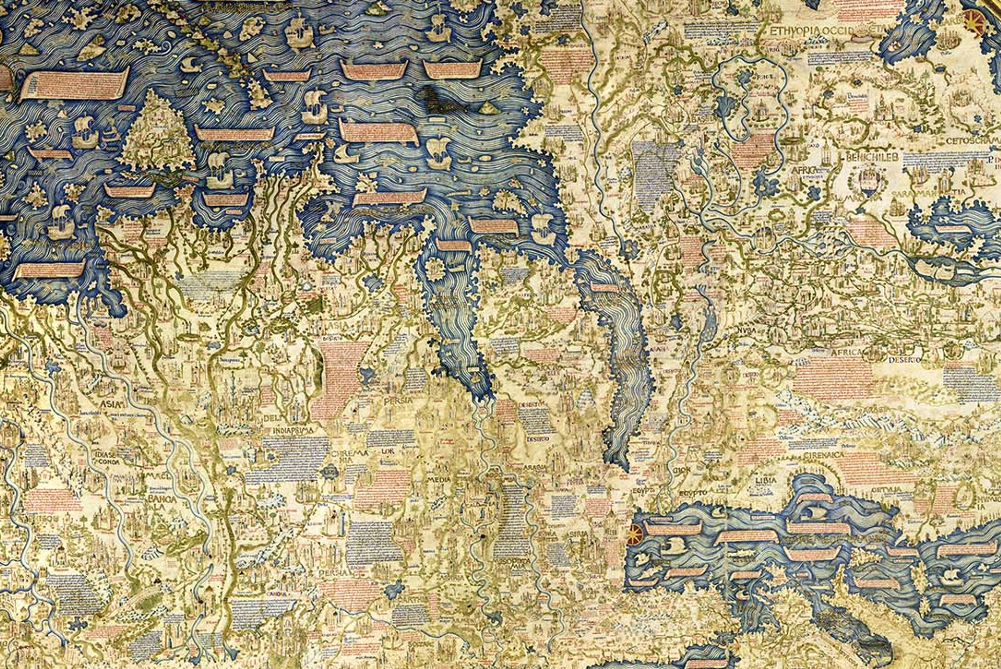
In this episode, Michael and Jerry explore Fra Mauro’s legendary world map from c. 1459. Measuring two metres across, this astonishing record of ancient trade routes, territories, ships, and cities was painted on vellum in vivid colours over a ten-year period. One of the most important sources of information for the map was Marco Polo’s Book of the Marvels of the World, first published in 1299.
Michael Yamashita is a distinguished photographer with over 40 years' experience working for National Geographic. Among his stunning collections of works capturing landscapes, peoples, and animals, Michael filmed two documentaries about Marco Polo for National Geographic in 2004 and 2022.
Michael recounts his voyages in the footsteps of Marco Polo, from the original copy of the Fra Mauro map in Venice, into war-torn regions in Asia. He also reflects on his own remarkable journey as a photographer, including his family’s recent history as Japanese-Americans during the Second World War.
To zoom in on the high-resolution image of the Fra Mauro map, click below:
Image Credit: Fra Mauro Map. Piero Falchetta, Public Domain, via Wikimedia Commons.
This extraordinary map was created by Fra Mauro (c1400-1464), a Venetian Monk who resided in the monastery of San Michele on an island between Venice and Murano. He ran a mapmaking workshop and was the cartographer for the monastery.
This is a manuscript map: meaning that it has been hand drawn and painted. It is presented on vellum - a high-quality fine-grain parchment made from calfskin - and backed on wood. It took a team of people around 10 years to help Fra Mauro complete this map, which was the most accurate map of the world in its time. It is the property of the National Marciana Library and on display in the iconic St Mark's Square, in Venice.

The Fra Mauro Map in Venice © Michael Yamashita
The map is oriented with South at the top, which is unusual compared to other European maps or Mappamundi of the period, and perhaps reflects an Islamic influence. It is considered by scholars to be both one of the last great medieval maps, and one of the first "modern" world maps.
Upon close inspection, the viewer can begin to recognise the names of countries, islands, seas and rivers, and the early shapes of the coastlines:
Southern Africa and the Cape of Good Hope are in the upper centre of the map, with the rest of the African continent taking up the top right.
The Eastern coastline from the Red Sea, Arabian Peninsula and Persian Gulf, traces across the Indian Ocean to the Indian Subcontinent and the Malay Peninsula. The enlarged islands of "Saylam" (Sri Lanka) and "Taprobana" (probably Sumatra) can be seen on the left, and as the map follows the curve of its spherical frame, the Island of "Cipangu" (also known as Japangu) emerges - the first appearance of Japan on a European map!
The Chinese, Russian and northern Scandinavian coasts wrap around the lower curve of the map; and in the lower right side is the Mediterranean Sea and Europe, with the familiar 'boot' of Italy, and Greece. The UK and Ireland can be found at the lower right.


Marco Polo's Book of the Marvels of the World © Michael Yamashita
The interior of Fra Mauro's map is overflowing with charming illustrations of the topography, landmarks, buildings and boats and contains over 3,000 annotations!
Many of these notes are recounted from stories told by Marco Polo in the Book of Marvels, an account of his travels written by Rustichello da Pisa. The book describes Marco Polo's 24-year adventure through Asia between 1271 and 1295 CE.

Mosaic Portrait of Marco Polo © Michael Yamashita
Marco Polo (1254-1324) was a Venetian explorer and merchant who travelled from his home in Venice to China, where he served at the court of Kublai Khan (1214-1294), the Mongol ruler and Emperor of the Yuan Dynasty
Accompanying his father and uncle, Marco Polo embarked on his 24-year journey from Italy to Asia when he was just 17 years old. He travelled along the famed Silk Road - a vast network of trade routes.

"Marco Polo: A Photographer's Journey" © Michael Yamashita
Following in the footsteps of Marco Polo on the 700th anniversary of his travels in 1999, Michael Yamashita was assigned an expedition from Venice to Asia by National Geographic, capturing breath-taking photos along the way. What began as a four-month assignment, became a two year adventure.
Michael set off from Venice, flying to Turkey, and then with his team travelled overland into the Middle East through Iraq and Iran, and into the war-zone of Afghanistan. They then headed to Kazakhstan and into the Pamir Mountains in Tajikistan, through to Pakistan, into Mongolia, Tibet and finally their destination, China. As well as being brought to life in a documentary series, it featured in National Geographic's May 2001 issue.


Because he was on assignment for the politically neutral National Geographic, Michael was able to travel through conflict zones where others, particularly journalists, could not. Michael reflects on some of the incredible scenes he saw and people he met along his journey; views that may not have changed since the 13th century and that Marco Polo himself may have experienced.
As he shares with Jerry, in addition to being an influential photographer, Michael is a changemaker: he 'broke the colour barrier' in 2008, when he became the first person of colour to work as a National Geographic photographer.
Today, Michael's career has come full circle: his first major assignment began in Hokkaido, and he has recently returned to Japan to further explore his roots, refine his craft, and reconnect with his 'happy place'.
Here are a selection of the shots Michael captured along his journey, each directly linked to passages recounted in the "Book of Marvels" and hence to Fra Mauro's legendary world map:


About Michael Yamashita

Michael Yamashita is an iconic, pioneering photographer. He has shot for the National Geographic for 40 years, combining his dual passions of travel and photography.
With an Asian Studies degree and fluent Japanese language skills, Michael has followed his roots to become a Far East expert. In addition to his work throughout Asia, which has included intensive concentrations in China, Japan, Korea and India, his assignments have taken him to six continents.
Michael is particularly well-known for retracing the paths of famous travellers like Marco Polo and the Chinese explorer/admiral Zheng He, capturing in the 21st century images that could easily have been seen in ancient times.
He has appeared as a TedX Speaker at his alma mater, Wesleyan University, and is a sought-after lecturer and instructor at photo workshops, universities and conferences across the globe.
Michael has won a host of industry awards, including those from the prestigious Pictures of the Year competition, Photo District News, the New York Art Directors Club, and the Asian American Journalists Association. His most recent exhibits include installations in Singapore, Hong Kong, Taipei and Tokyo, as well as in Pisa, Italy, Frankfurt, Germany, The Carter Center in Atlanta, Los Angeles County Museum of Art and the National Gallery of Art in Washington, D. C.
Along with two documentary feature films inspired by his extensive coverage of Marco Polo and Zheng He, Michael has produced 16 books on topics as diverse as Japanese gardens and Shangri-La.
When not traveling, he can be found with his family at his home and studio in rural New Jersey, where he is an active volunteer fireman.

© Michael Yamashita
A new episode of WHAT'S YOUR MAP? will be available every two weeks. Why not continue your exploration of the wonderful world of maps by subscribing? That way you'll never miss an episode.
Feel free to let us know - What's YOUR Map?!

