Maps: Digital | Analogue
Proudly held with the Bodleian Libraries, Oxford

The Sunderland Collection Symposium ‘Maps: Digital | Analogue’ took place online and in person at the Bodleian Libraries on 26 February 2026. It was an enlightening day of talks and panel discussions about early and modern cartography.
In the morning, we delved into the challenges and revelations of digitising early maps, with Nick Millea of the Bodleian Library, and Donna Sherman and Jamie Robinson of the Rylands Institute and Library. Then we leapt into the fantastical world of online gaming maps with Eric de Broche des Combes of Luxagon.
In the afternoon we went analogue, starting with a talk on historic globes by Sylvia Sumira, followed by a panel discussion between Drs. Diana Lange and Oliver Hahn about the pigments and colours on early East Asian maps, moderated by Dr. Sara Öberg Strådal.
Scroll down to watch recordings of each presentation.


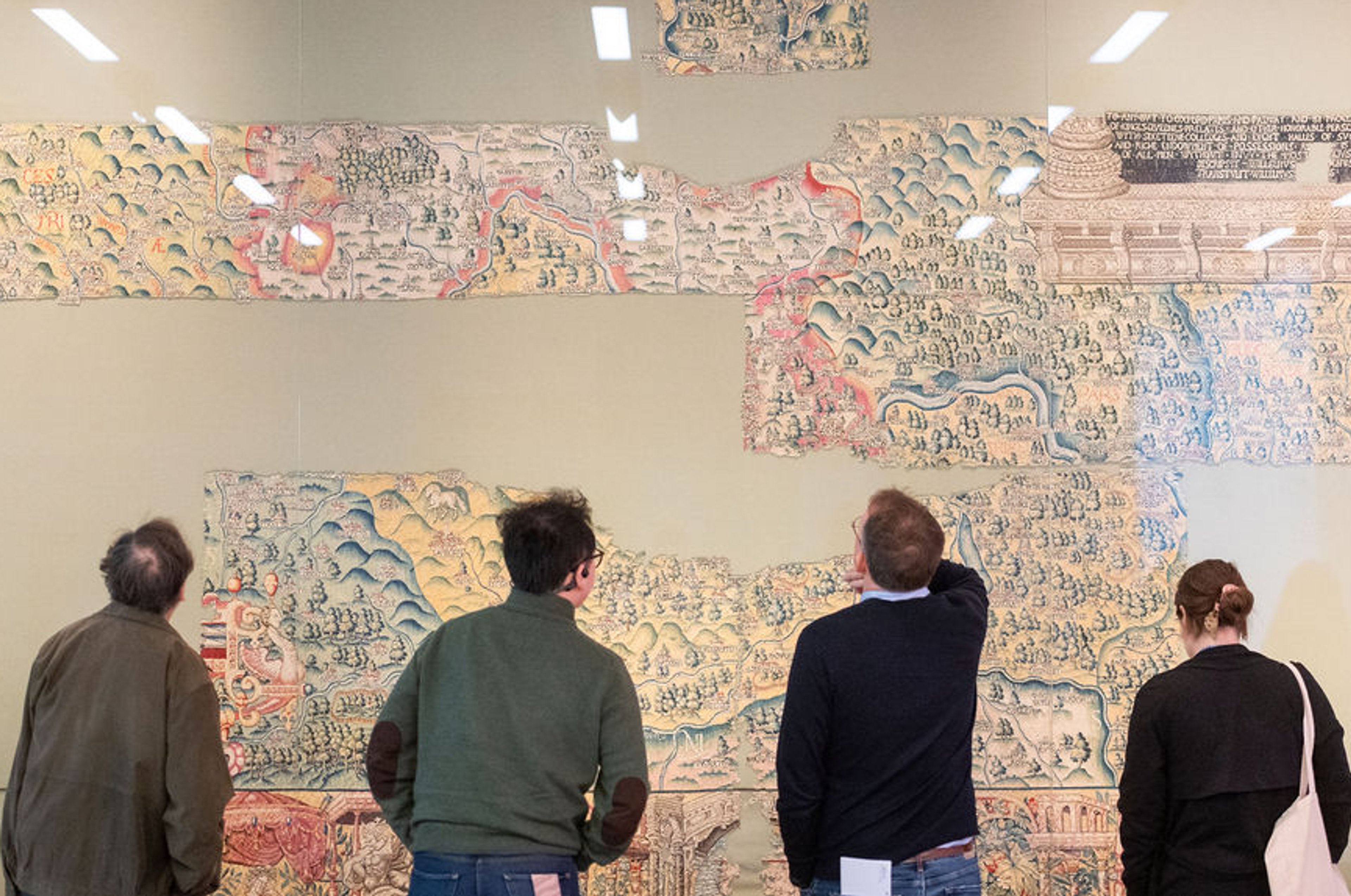
The Sheldon Tapestry Maps:
A Digital Re-Imagining of the Tudor Landscape
Nick Millea discusses the history of the remarkable sixteenth-century Sheldon Tapestry Maps, and the challenges of reconstructing them through digitisation.
Imagery from the Bodleian Libraries, University of Oxford, The National Trust, and Factum Arte.
"Non Du Tout Descouverte":
Exploring the Hidden Lives of Two Maps from the John Rylands Library
Map Curator Donna Sherman and Imaging Manager Jamie Robinson introduce us to the legacy of digitisation at the John Rylands Library, and how it has helped discover the secrets of the Desceliers Mappamundi and the Borgia/Velletri map.
Source materials from the John Rylands Institute and Library, University of Manchester.


It is pitch black. You are likely to be eaten by a grue.
A History and Imagining of Online Gaming Maps.
Architect and graphic designer Eric de Broche des Combes from the Harvard Graduate School of Design takes us on a journey into another dimension: the world of online gaming maps. Through eight case studies, Eric shows how these maps were inspired by, and continue to push the boundaries of, traditional cartography.
Copyrights in screenshots, recordings of gameplay, and trailers is retained by the studios and artists.
The Model World, the Model Heavens.
The Making and Conservation of Globes
Leading globe authority Sylvia Sumira takes us behind the scenes in her studio as an expert and conservator of historic globes. She explains how early globes were made, and the challenges of their conservation.
Images courtesy of Sylvia Sumira and cited European institutions.


Colours on Maps: Purpose and Materiality
Professors Dr. Diana Lange from the Humboldt University of Berlin, and Dr. Oliver Hahn of Hamburg University, discuss their pioneering research into colours and pigments on maps, through the lens of early East Asian cartography.
They then discuss their work further with Dr Sara Öberg Strådal, a specialist in Medieval scientific manuscripts and volvelles.
Presentations contain imagery from the Bodleian Library collection, Vatican Library, and Das Museum am Rothenbaum (MARKK). Publication permissions held by Dr. Diana Lange.


In-person attendees at the Symposium were treated to an exhibition of maps and atlases, where the Sheldon Tapestry Map of Oxfordshire was also on display.
These included the 1780 Korean Atlas from The Sunderland Collection, high-resolution facsimiles of the 1546 Desceliers Mappamundi and the fifteenth century Borgia/Velletri Map from the John Rylands Library, an early East Asian manuscript map from the Bodleian Libraries collection, and a selection of minerals and pigments used to colour early maps in Europe and Asia.


Meet the Speakers

Nick Millea is the Map Curator at the Bodleian Libraries, an Honorary Fellow and 'Bartholomew Globe' winner at the Royal Scottish Geographical Society, and Chair of the British and Irish Committee for Map Information and Cataloguing Systems. He is also a founding member of The Oxford Seminars in Cartography.
Nick has published extensively on maps, including 50 Maps and the Stories They Tell, co-authored with Jerry Brotton. He has curated several exhibitions at the Bodleian, including Talking Maps.
Image ©John Cairns

Donna Sherman is the Special Collections Librarian and Map Curator at the University of Manchester Library. She has over 15 years’ experience working with geospatial collections. She has an undergraduate degree in visual arts and culture, and master’s degree in librarianship.
She is a member of the British Cartographic Society, British and Irish Committee for Map Information and Cataloguing Systems (BRICMICS), Manchester Geographical Society and GIS, Mapping and Earth Observation Research Group.
Image ©Donna Sherman

Jamie Robinson has worked in heritage imaging at the University of Manchester for over nineteen years. He has been developing multispectral imaging at the Rylands Library since 2011 and now manages the Rylands Heritage Imaging Lab.
In 2025, Jamie completed a master's degree with distinction in Library and Archive Studies. His thesis, NON DU TOUT DESCOUVERTE, examined the Desceliers Map and demonstrated how object biographies can be reconstructed through heritage science.
Image ©Jamie Robinson

Eric de Broche des Combes is an architect, graphic designer, and musician. He studied architecture at the École Nationale Supérieure d’Architecture de Marseille and later completed a postgraduate research cycle at the GAMSAU.
Based in Paris, he founded the visualization studio Luxigon, which produces images and films for architecture, and also runs architectural practice Buro BC. He is a professor at Harvard Graduate School of Design, teaching courses on worldbuilding and landscape architecture.
Image ©Eric de Broche des Combes

Sylvia Sumira is an independent conservator specialising in globes. Following a History of Art degree, she gained a post-graduate diploma in paper conservation. She worked in globe conservation at the National Maritime Museum in Greenwich, and the Austrian National Library in Vienna.
Sylvia has many publications to her name, including her book ‘The Art and History of Globes’ (2014). She is a member of the UK Institute of Conservation and a Fellow of the International Institute for Conservation of Historic and Artistic Works.
Image ©Sylvia Sumira

Diana Lange is Professor for History and Cultures of Central Asia at the Humboldt-Universität zu Berlin, Germany. Specialising in Tibet, the Himalayas, and East Asia, Diana’s research interests are broad, encompassing the history of knowledge and exploration, material and visual cultures, mapping and cartography, and cultural interactions.
Her publication, Colours on East Asian Maps: Their Use and Materiality in China, Japan and Korea between the Mid-17th and Early 20th Century (Brill, 2023) was co-authored with Dr. Oliver Hahn.
Image ©Diana Lange

Oliver Hahn received his PhD in Chemistry in 1996. He works for the Bundesanstalt für Materialforschung und -prüfung (BAM, or the Federal Institute for Materials Research and Testing) in Berlin.
Oliver is Head of 'Analysis of Artefacts and Cultural Assets,' and has been a Professor at University of Hamburg's Arts Faculty since 2014. His areas of interest include the scientific analysis of manuscripts, colorants and inks as well as the preservation of Germany’s cultural heritage.
Image ©Oliver Hahn

Dr Sara Öberg Strådal is an art historian and expert in medieval scientific and medical images and diagrams (MPhil and PhD, University of Glasgow). Her previous work at the Fitzwilliam Museum, University of Cambridge and, most recently, as a Getty/ACLS Research Fellow focused on volvelles and the circulation of interactive diagrams in manuscripts, print, and other media.
She is the Managing Director at Dr. Jörn Günther Rare Books, the world-leading specialist dealer of Medieval and Renaissance manuscripts and miniatures.
Image ©Dr. Jörn Günther Rare Books

Bodleian Libraries is the library service supporting the University of Oxford. Its mission is to support the learning, teaching and research objectives of the University; and to develop and maintain access to Oxford's unique collections for the benefit of scholarship and society.
Libraries in the group include the Bodleian Library itself - founded in 1606 - alongside 25 other libraries across Oxford. Together, the Libraries hold more than 13 million printed items, over 80,000 e-journals and outstanding special collections including rare books and manuscripts, classical papyri, maps, music, art and printed ephemera.
Bodleian Libraries are also a key part of Oxford’s cultural community and leads an exciting programme of public exhibitions and events to engage communities with collections.
Find out more about the Libraries and their forward programme of events at www.bodleian.ox.ac.uk


About the Sunderland Collection Symposia
The Sunderland Collection Symposia are dynamic, hybrid conferences that aim to bring map enthusiasts of all backgrounds into conversation with the latest ideas and developments.
You can find links below to our first Symposium at the Bodleian Libraries in October 2024, and our conference held at the Royal Geographical Society in October 2025 below.
All photography by John Cairns and Anya Cooklin-Lofting. ©The Sunderland Collection. Filming and production by Steve Pierce (Film Shed).
Sign up to the Oculi Mundi Newsletter to be notified of future conferences and events:

