Barbara A. Bond
Series 4 Episode 4
Smuggling Silk: WWII Escape Maps with Dr. Barbara A. Bond
Series 4 Episode 4
Available on all major podcast platforms: click the icons or hit 'play' to listen now.
In this episode, Jerry speaks with the illustrious Barbara A. Bond, the former cartographic researcher in the UK’s Ministry of Defence. Together, they pore over an important but unassuming silk escape map of Danzig (Gdańsk) port from World War II. What information is presented on the map, and what has been intentionally excluded? More importantly, how did this map end up in the hands of a Prisoner of War hoping to escape the enemy in Europe?
We gain access all areas to Barbara’s astounding career in mapping. Jerry hears highlights from her first exposure to maps as a child, to her tenure as President of the British Cartographic Society and Director of the Hydrographic Office in the UK. Along the way, we gain insight to her PhD research on MI9's escape and evasion mapping programme in WWII, resulting in her brilliant book Great Escapes.
To view the map while you listen, click the image below!
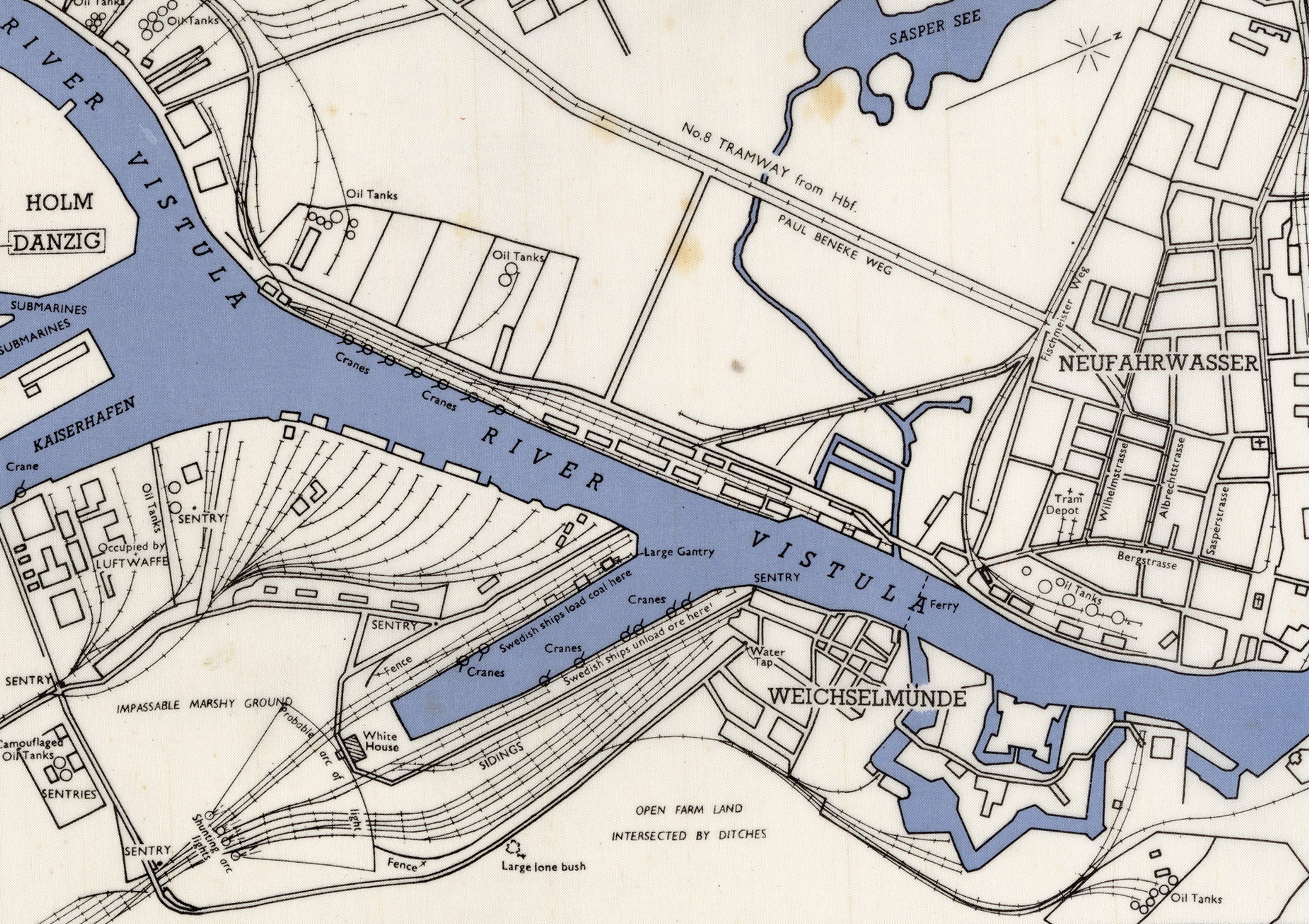
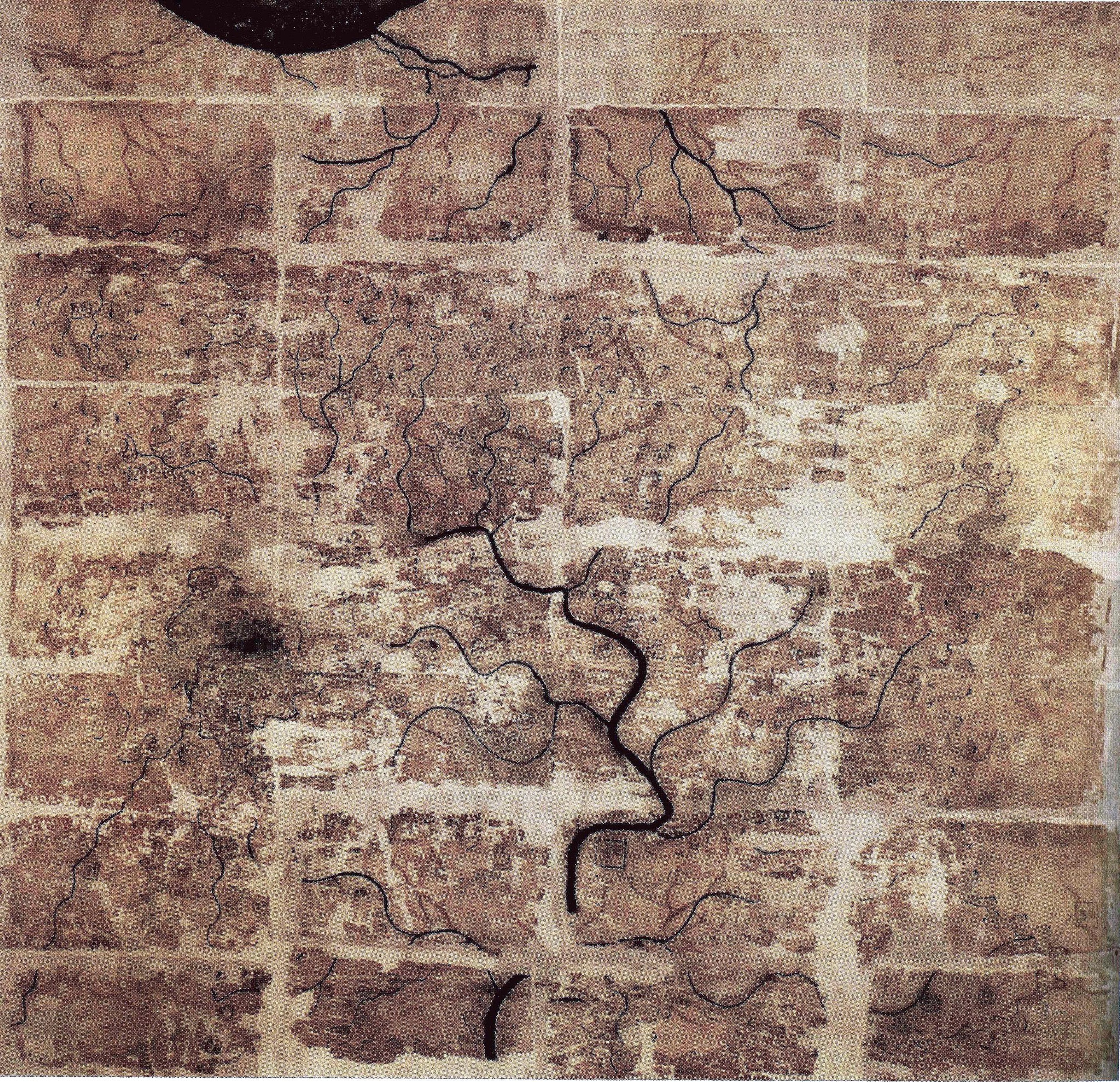
Silk escape map of Danzig Port (1942) ©Courtesy of the Military Intelligence Museum
This is a 1942 silk escape map of the port of Danzig - modern day Gdańsk - in Poland. The map, oriented northwest at the top, covers the area immediately surrounding the Wisłoujście Fortress (‘Weichselmünde’) and Nowy Port (‘Neufahrwasser’) in the city’s dockyards.
On first inspection it comes across as a traditional port atlas map with railway terminals and the River Vistula flowing through the centre. However, if you look closely you will notice that there are only six street names and the map highlights some rather unconventional landmarks... The loading dock for the Swedish coal ships, the location of the sentry guards, the impassable marshy ground, open farmland intersected by ditches, the possible area illuminated by an arc of light, and a large lone bush. These details would help you to determine your position.
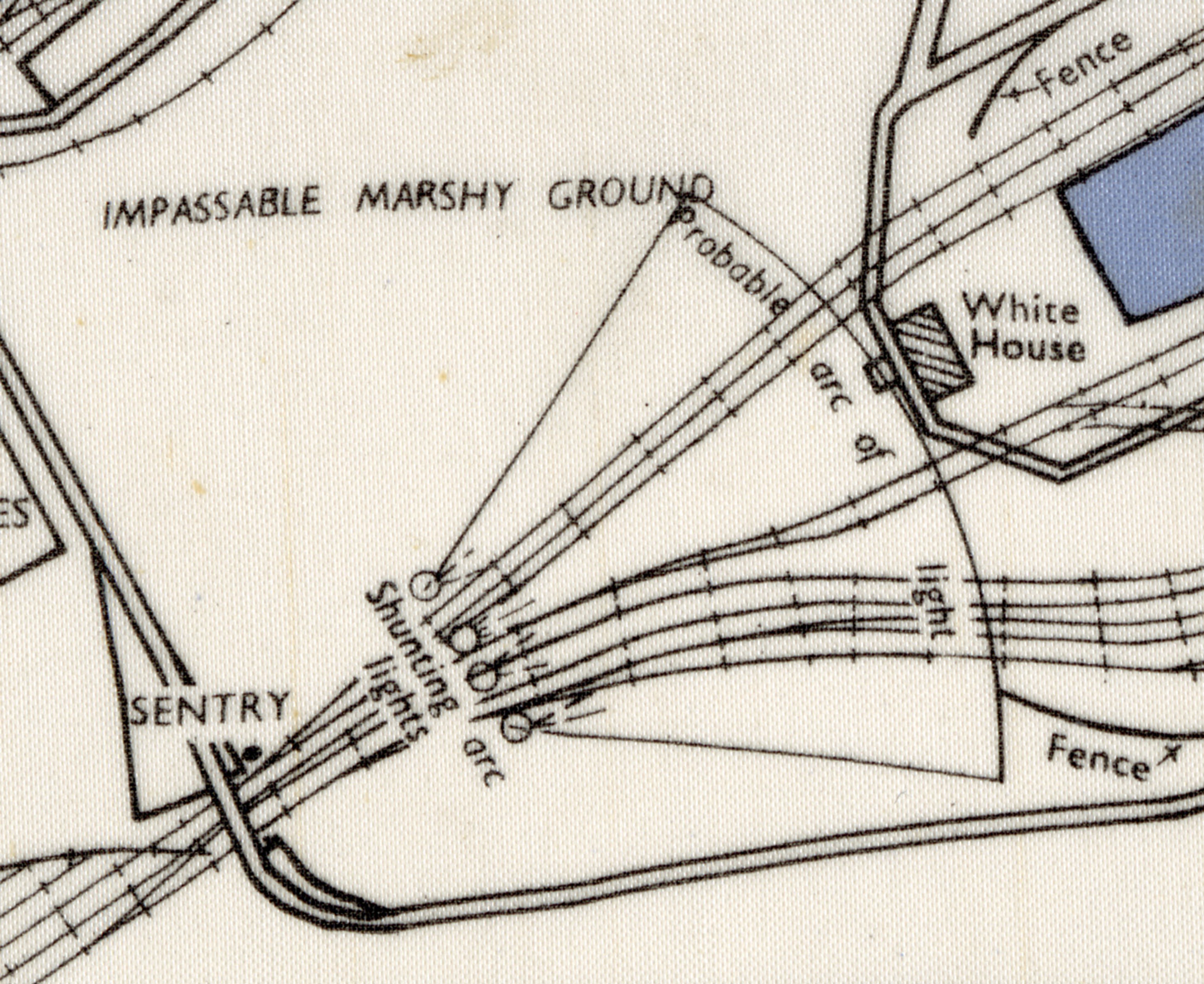
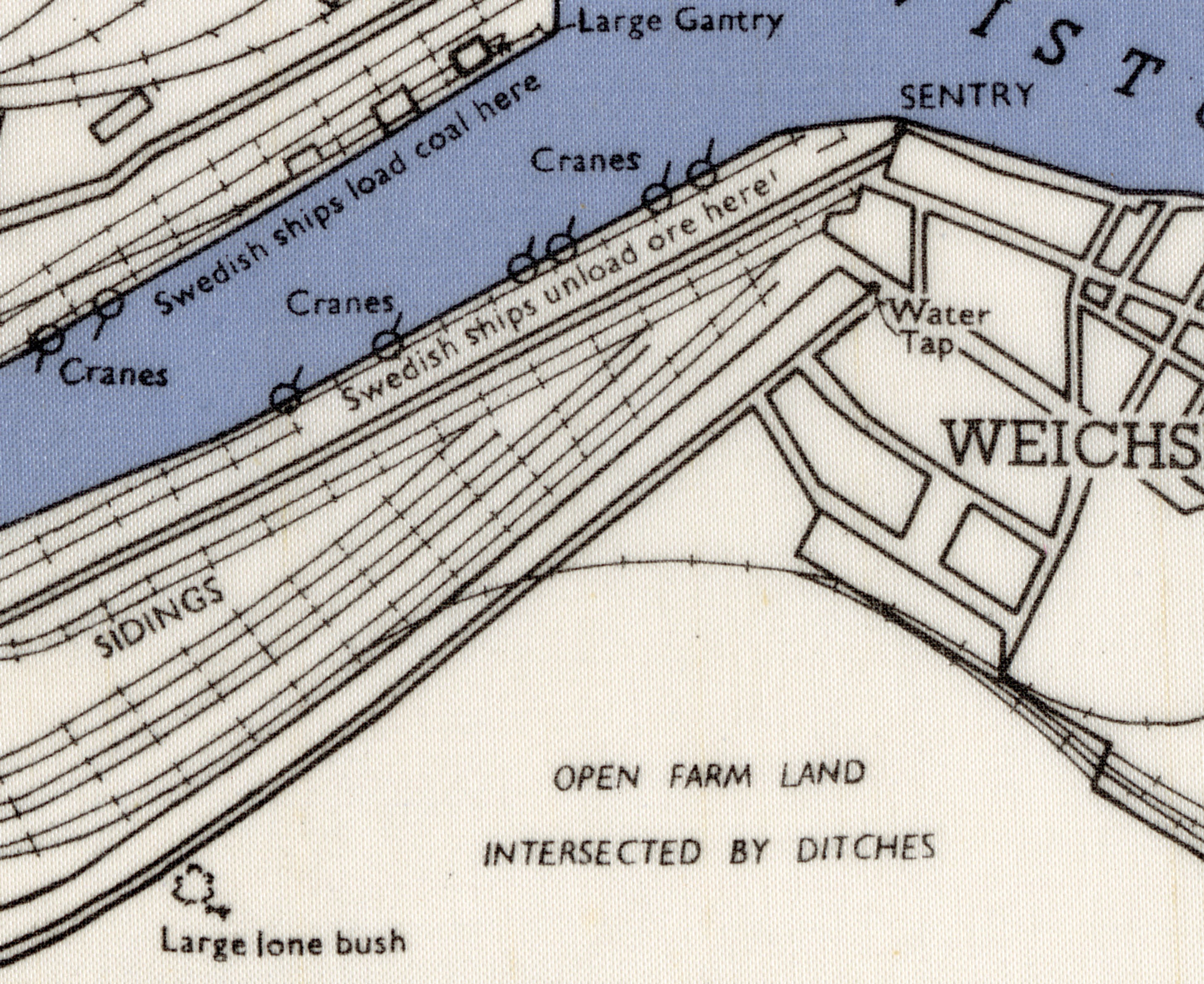
This map, ‘Sheet A.4.’, is just one in a complex series of silk maps covering western Europe, and would have acted as the final stage of an Allied Prisoner of War’s journey to freedom, by way of a coal cargo ship to Sweden. If this attempt was not successful, it could mean the difference between life or death.
It is important to appreciate the small physical size and the large 1:16,000-scale of the map, making this a challenging feat for the navigator. Cartographically it would have been based on a British Admiralty double sea chart of Gdansk and Gdynia, and each morsel of information printed would have been carefully chosen to prompt its user of possible escape routes and hideout locations to evade capture by the Germans.
These maps were the brainchild of M.I.9, or Military Intelligence Section 9, a special branch of the British War Office established during the Second World War. Founded in December 1939, their main objective was to create a network of escape and evasion routes across Europe and provide support to fleeing Allied soldiers and Prisoners of War in their return to the UK. You can find out more about M.I.9 here.
Osher Map Library and Smith Center for Cartographic Education. OML-1943-48.
At the time, Danzig was one of several vital Baltic ports that M.I.9 recommended for escape - along with Gdynia, Stettin and Lübeck. Each location acted as the final stage for Prisoners of War or escaping servicemen and women, each port offering an opportunity to reach neutral power Sweden and be sent home. Barbara explains in her book ‘Great Escapes’ that “In extremis, some escapers resorted to Finnish ships in the hope that they planned to dock in a Swedish port on their return trip to Finland.” It is calculated that 30 percent of escaped personnel came via this route to Sweden.
M.I.9 compiled a comprehensive map of Europe based on intelligence gathered from every successful escaper. Each individual was debriefed to extract the maximum amount of information about their journey and methods to facilitate the liberation of further evaders and escapers. Prior to all missions, M.I.9 would have also distributed a Bulletin and guidance on everything from appropriate conduct when in danger through to how to request assistance from a neutral country, such as Sweden or Switzerland.
These practical little maps were printed on cloth and silk - and later when silk was rationed for making parachutes, Rayon was used. Maps just like this one of Danzig were a handy size, did not rustle, and were remarkably durable. They could be folded down to be incredibly discreet, sewn into the lining of clothing, or simply stashed away. Approximately 300 of this particular map of Danzig were published, with half issued on silk and half on paper as part of the M.I.9 Bulletin.
Public domain via Wikimedia Commons
The history of maps on cloth dates back to the 2nd Century BCE. Three maps excavated between 1972-1974 from Tomb #3 of the Mawangdui Ch’ang-sha in the Hunan Province, China were produced on silk: a topographic map of the region, a city map, and a military map known as the ‘Garrison Map’. At the time of their discovery, they were the oldest known maps in China.
Other early examples of cloth maps have been found from the American Civil War (1861-1864) by the Topographical Engineers who produced General Sherman’s campaign maps, and the British National mapping agency Ordnance Survey who published a selection of maps covering the Lake District (1891). These would have in-directly inspired M.I.9 when devising escape solutions.

Public domain via Wikimedia Commons
A key figure in M.I.9’s endeavours was Christopher Clayton “Clutty” Hutton (1893-1965). A soldier, journalist, inventor and the Lead Technical Officer of Section Z at M.I.9, the department responsible for the production and supply of escape tools. Hutton is thought to have inspired the James Bond character 'Q'.
In coordination with Sections X and Y, Hutton and his team would plan the objects in which to secrete escape and evasion tools and maps, and assist in the planning of escape lines and the logistics of deliveries of coded communication and escape materials into the camps. Hutton was fascinated by magicians and the art of the illusion, and it was thanks to his playful ingenuity that these silk maps and escape kits would make their way to POWs.
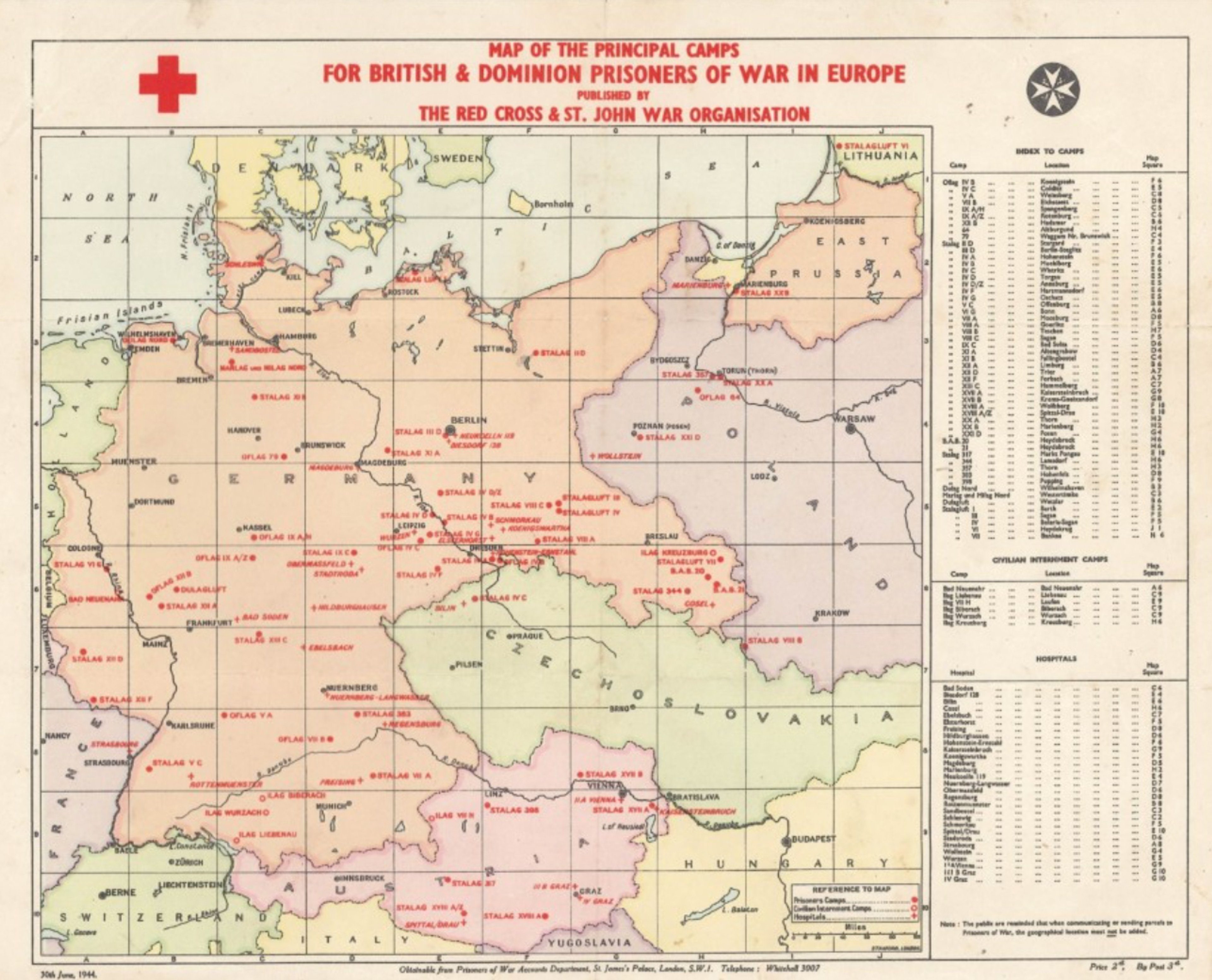
Red Cross Map of Prisoner of War Camps in Europe Second World War & Holocaust Partnership Project by The Imperial War Museum and Industrial Museums Scotland funded by The National Lottery Heritage Fund.
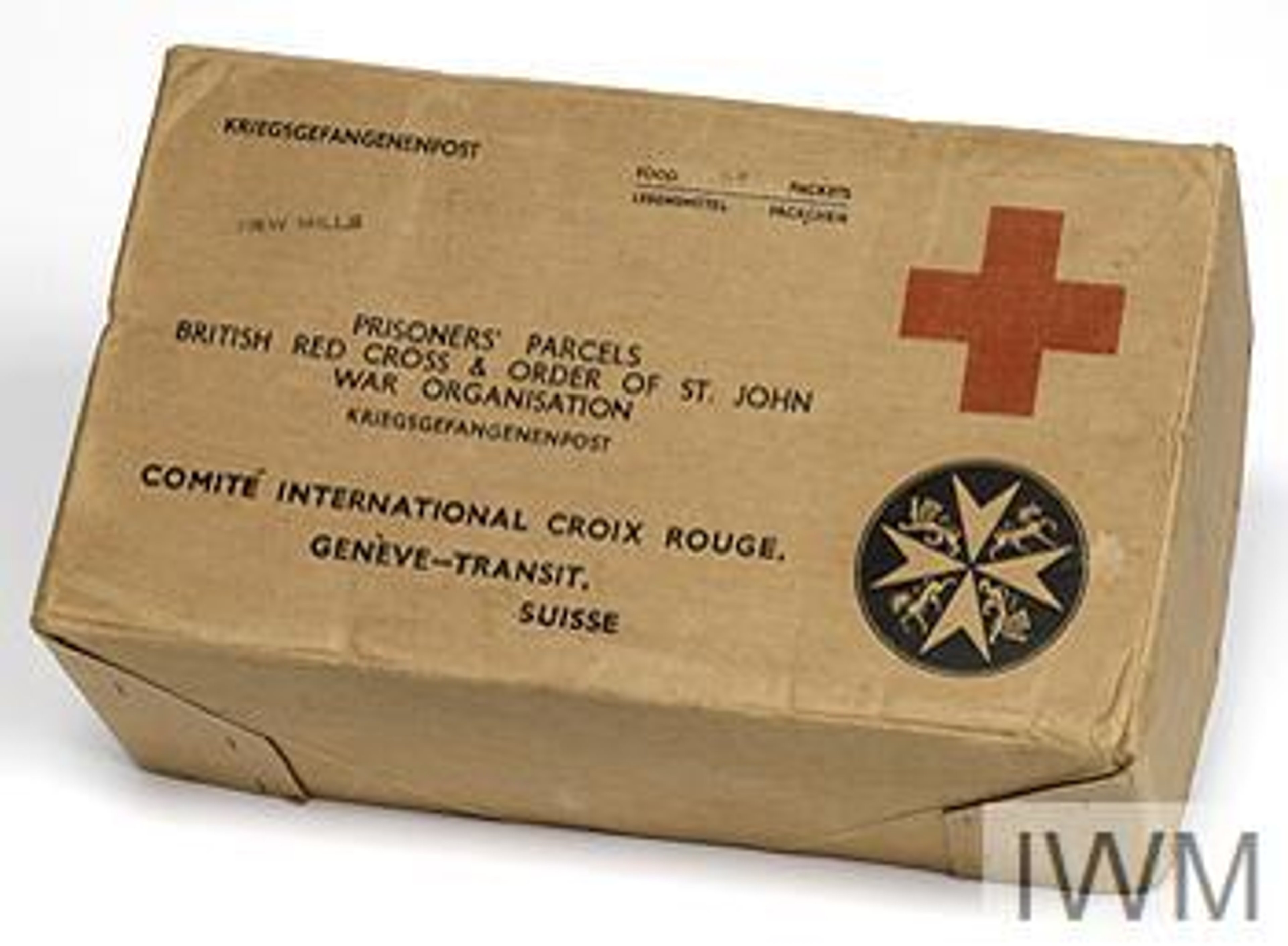
As Barbara tells Jerry, the maps were smuggled into the Prisoner of War encampments via very creative measures. POW camps across Europe would be permitted to receive mail from humanitarian charities, such as the Red Cross. M.I.9 would use this opportunity to masquerade as niche charity outfits: the Old Ladies Knitting Committee, Jig Saw Puzzle Club, and the Author’s Society to name but a few of their aliases. Through these disguises they would send POWs aid parcels with everyday items and games for prisoners to boost morale.
Innovatively concealed within shoes, buttons, records, musical instruments, stationery, shaving kits, playing cards and games were silk maps and miniature tools. A famous example of silk maps being smuggled into POW camps was inside the popular board game Monopoly.
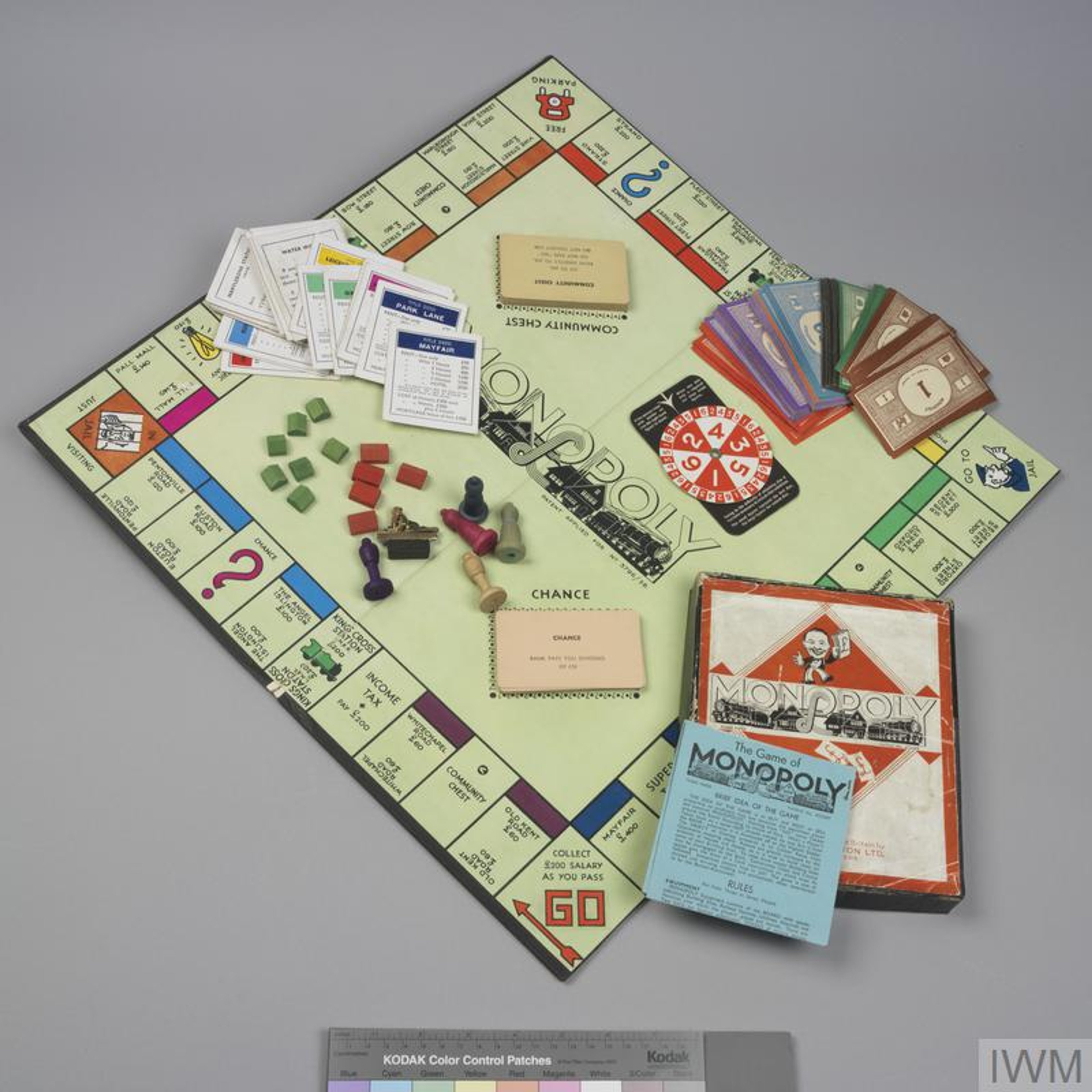
Working with Hutton and his colleagues, game manufacturer John Waddington Ltd very cleverly managed to hide maps within the game board, along with an array of other kit for escapers, such as miniature compasses in game tokens and high-denomination currency from all over Europe amongst the fake Monopoly money. The Leeds-based firm was already a crucial commercial partner for M.I.9 as they had the unique facility to print on silk. A small team would work covertly in their factory to assemble these rigged games.
Before embarking on any mission, British and American air crews were taught how to identify doctored games of Monopoly which were all marked with an insignificant printing glitch in the ‘Free Parking’ square. The maps that made it thorough into POW camps would have then been hand-copied by other prospective escapers and intel distributed amongst the inmates.
As Barbara shares, M.I.9’s incredible contributions saved the lives of around 36,000 people!
This map of Danzig is one of many maps and artefacts held by the vast specialist archive at the Military Intelligence Museum, situated at the UK’s Intelligence Training headquarters at MOD Chicksands in Bedfordshire.
The Military Intelligence Museum tells the story of British military intelligence from the Boer War to the modern day. Through their unique collection, they unveil the tactics, techniques and equipment used by the people who have carried out their important tasks across the years, often in secret, with courage and determination. You can find out more, plan your visit and support their mission by visiting their website, militaryintelligencemuseum.org
Oculi Mundi would like to thank the Military Intelligence Museum, in particular Archivist Cameron Dewson for their kind assistance and for permission to display an image of Barbara’s chosen map.
About Barbara Bond

Courtesy of Barbara A. Bond
Barbara Bond spent her career as a map researcher in the Ministry of Defence, initially in the Mapping and Charting Establishment, RE (now the Defence Geographic Centre), and later in the UK Hydrographic Office, where she became the senior civilian Director and Deputy Chief Executive.
She is a Fellow and past-Council member of the Royal Geographical Society, and a past-President of the British Cartographic Society. She was Chair of the International Hydrographic Organization’s Antarctic Commission from 1992–97. Barbara was awarded the Silver Medal for services to international cartography by the British Cartographic Society and is a recipient of the prestigious Prince Albert I Medal, presented by His Serene Highness Prince Rainier III of Monaco.
She is the former Pro-Chancellor of Plymouth University and pursued a PhD degree at Plymouth, which she successfully completed in September 2014.
You can read Barbara's PhD thesis titled M.I.9's escape and evasion mapping programme 1939-1945 here.
Her acclaimed book, Great Escapes (Times Books, 2015), is the result of both Barbara’s doctoral degree, and a long-standing interest in M.I.9 and its unique mapping programme.
Why not continue your exploration of the wonderful world of maps by subscribing to the podcast? That way you will never miss an episode.
Feel free to let us know - What's YOUR Map?!

