Selected Bibliography
Key resources about maps and cartography, including those used in the 'Research' environment of The Sunderland Collection.
Baltimore Museum of Art and Walters Art Gallery. 1952. The World Encompassed: An Exhibition of the History of Maps Held at the Baltimore Museum of Art, October 7 to November 23. Baltimore: Walters Art Gallery.
Broecke, M. P. R. van den. 2011. Ortelius Atlas Maps: An Illustrated Guide. Houten: Hes & de Graaf.
Broecke M. P. R. van den, P. C. J. van der Krogt, and Peter H. Meurer. 1998. Abraham Ortelius and the First Atlas: Essays Commemorating the Quadricentennial of His Death, 1598–1998. Houten: Hes & de Graaf
Brotton, Jerry. 2013. A History of the World in Twelve Maps. New York: Viking.
Brown, Basil J. W. 1932. Astronomical Atlases, Maps, and Charts: An Historical and General Guide. London: Search Publications.
Burden, Philip D. 2007. The Mapping of North America: A List of Printed Maps. Rickmansworth Herts: Raleigh.
Campbell, Tony. 1988. The Earliest Printed Maps 1472–1500: Describing the Maps Listed in Marcel Destombes’s ‘Catalogue Des Cartes Gravées Au Xve Siècle’ of 1952. Berkeley: University of California Press, 1988.
Cook, James and J. C Beaglehole. 1955–1974. The Journals of Captain James Cook on His Voyages of Discovery. 4 vols. Cambridge: Published for the Hakluyt Society at the University Press.
Dekker, Elly and Peter C. J. van der Krogt. Globes from the Western World. London: I.B. Tauris.
Destombes, Marcel, ed. 1964. Mappemondes, A.D. 1200–1500: Catalogue prepare par la Commissiondes Cartes Anciennes del’Union Geographique Internationale. Amsterdam: Nico Israel.
Goff, Frederick. 1964. Incunabula in American Libraries: A Third Census of Fifteenth-Century Books Recorded in North American Collections. New York: Bibliographical Society of America.
Hagen, Gottfried. 2012. ‘Kātip Çelebi's Maps and the Visualization of Space in Ottoman Culture’ Osmanlı Araştırmaları 40: 283–93.
Harley, J. B, David Woodward, et al., ed. 1987–. The History of Cartography. 6 vols. Chicago: University of Chicago Press.
Harris, Elizabeth. 1985. ‘The Waldseemüller World Map: A Typographic Appraisal’, Imago Mundi 35: 30–53.
Karrow, Robert. 1993. Mapmakers of the Sixteenth Century and Their Maps: Bibliographies of the Cartographers of Abraham Ortelius 1570, Based on Leo Bagrow's Ortelii Catalogus Cartographorum. Chicago: Newberry Library.
Keuning, Johannes. 1951. ‘The Novus Atlas of Johannes Janssonius’, Imago Mundi 8: 71–98.
Kline, Naomi Reed. 2001. Maps of Medieval Thought: The Hereford Paradigm. Woodbridge: Boydell.
Koeman, Cornelis and P. C. J. van der Krogt. 2003. Koeman's Atlantes Neerlandici. Goy-Houten: HES & de Graaf.
Krogt, Peter C. J. van der. 1993. Globi Neerlandici: The Production of Globes in the Low Countries. Utrecht: H & S.
Krogt, Peter C. J van der. 2001. The Most Magnificent and Largest Globes of Blaeu, the World's Greatest Globe Maker. Boston: Brill.
Manners, Ian and Emiralioğlu M. Pinar. 2010. European Cartographers and the Ottoman World, 1500– 1750: Maps from the Collection of O. J. Sopranos. Chicago: University of Chicago Press.
Mickwitz, Ann-Mari, Leena Miekkavaara, et al. 1979–1989. The A. E. Nordenskiöld Collection in the Helsinki University Library: Annotated Catalogue of Maps Made Up to 1800. 4 vols. Helsinki: Helsinki University Library.
Mollat, Michel and Monique de La Roncière. 1984. Sea Charts of the Early Explorers: 13th to 17th Century. New York: Thames and Hudson.

Harley, J. B, David Woodward, et al., ed. 1987–. The History of Cartography. 6 vols. Chicago: University of Chicago Press.
Harris, Elizabeth. 1985. 'The Waldseemüller World Map: A Typographic Appraisal’, Imago Mundi 35: 30–53.
Kanas, Nick. 2019. Star Maps: History, Artistry, and Cartography. Third Edition. Praxis Publishing/Springer
Karrow, Robert. 1993. Mapmakers of the Sixteenth Century and Their Maps: Bibliographies of the Cartographers of Abraham Ortelius 1570, Based on Leo Bagrow's Ortelii Catalogus Cartographorum. Chicago: Newberry Library.
Keuning, Johannes. 1951. ‘The Novus Atlas of Johannes Janssonius’, Imago Mundi 8: 71–98.
Kline, Naomi Reed. 2001. Maps of Medieval Thought: The Hereford Paradigm. Woodbridge: Boydell.
Koeman, Cornelis and P. C. J. van der Krogt. 2003. Koeman's Atlantes Neerlandici. Goy-Houten: HES & de Graaf.
Krogt, Peter C. J. van der. 1993. Globi Neerlandici: The Production of Globes in the Low Countries. Utrecht: H & S.
Krogt, Peter C. J van der. 2001. The Most Magnificent and Largest Globes of Blaeu, the World's Greatest Globe Maker. Boston: Brill.
Manners, Ian and Emiralioğlu M. Pinar. 2010. European Cartographers and the Ottoman World, 1500– 1750: Maps from the Collection of O. J. Sopranos. Chicago: University of Chicago Press.
Mickwitz, Ann-Mari, Leena Miekkavaara, et al. 1979–1989. The A. E. Nordenskiöld Collection in the Helsinki University Library: Annotated Catalogue of Maps Made Up to 1800. 4 vols. Helsinki: Helsinki University Library.
Mollat, Michel and Monique de La Roncière. 1984. Sea Charts of the Early Explorers: 13th to 17th Century. New York: Thames and Hudson.
National Library of Australia. 2013. Mapping Our World: Terra Incognita to Australia. Canberra: National Library of Australia.
Nebenzahl, Kenneth. 1986. Maps of the Holy Land: Images of Terra Sancta through Two Millennia. New York: Abbeville.
Needham, Joseph. 1974. ‘Astronomy in Ancient and Medieval China’, Philosophical Transactions of the Royal Society of London 1257: 67–82.
Nordenskiöld, A. E. 1897. Periplus: An Essay on the Early History of Charts and Sailing-Directions. Stockholm: P. A. Norstedt.
Pankenier, David. 2013. Astrology and Cosmology in Early China: Conforming Earth to Heaven. Cambridge: Cambridge University Press.
Pegg, Richard. 2014. Cartographic Traditions in East Asian Maps. Honolulu: University of Hawaiʻi Press.
Pflederer, Richard. 2009. Census of Portolan Charts and Atlases: As Reported and Listed by the Noted Scholars of the Genre in their Works Ranging from 1897 to 2008. Williamsburg: Richard Pflederer.
Pflederer, Richard. 2012. Finding Their Way at Sea: The Story of Portolan Charts, the Cartographers Who Drew Them, and the Mariners Who Sailed by Them. Houten: Hes & De Graaf.
Philips, Philip Lee and Clara Egli Le Gear.1909–1992. A List of Geographical Atlases in the Library of Congress, with Bibliographical Notes. 9 vols. Washington D.C.: Library of Congress.
Ping, Yan. 1998. China in Ancient and Modern Maps. London: Sotheby’s.
Rüstem, Ünver. 2022. ‘Mapping Cosmopolitanism: An Eighteenth-Century Printed Ottoman Atlas and the Turn to Baroque’, Ars Orientalis 51: Digital Publication.
Sabin, Joseph Wilberforce. 1868. Bibliotheca Americana: A Dictionary of Books Relating to America, from its Discovery to the Present Time. New York: Joseph Sabin.
Schilder, Günter and Olaf Richter. 1976. Australia Unveiled: The Share of the Dutch Navigators in the Discovery of Australia. Amsterdam: Theatrum Orbis Terrarum.
Shirley, Rodney. 2001. The Mapping of the World: Early Printed World Maps, 1472–1700. Riverside: Early World Press.
Shirley, Rodney. 2004. Maps in the Atlases of the British Library: A Descriptive Catalogue, c. AD 850– 1800. London: British Library.
Skelton, R. A. 1960. Explorers' Maps: Chapters in the Cartographic Record of Geographical Discovery. London: Routledge and K. Paul.
Suárez, Thomas. 1999. Early Mapping of Southeast Asia. Singapore: Periplus.
Tooley, Roland V. 1979. The Mapping of Australia. London: Holland Press.
Tyacke, Sarah. 1978. London Map-Sellers, 1660–1720: A Collection of Advertisements for Maps Placed in the London Gazette, 1668–1719 with Biographical Notes on the Map-Sellers. Tring: Map Collector Publications.
Urton, Gary. 1981. At the Crossroads of the Earth and the Sky: An Andean Cosmology. Austin: University of Texas Press.
Wagner, Henry. 1999. Cartography of the Northwest Coast of America to the Year 1800. Mansfield Centre: Martino.
Warner, Deborah. 1979. The Sky Explored: Celestial Cartography, 1500–1800. New York: A.R.
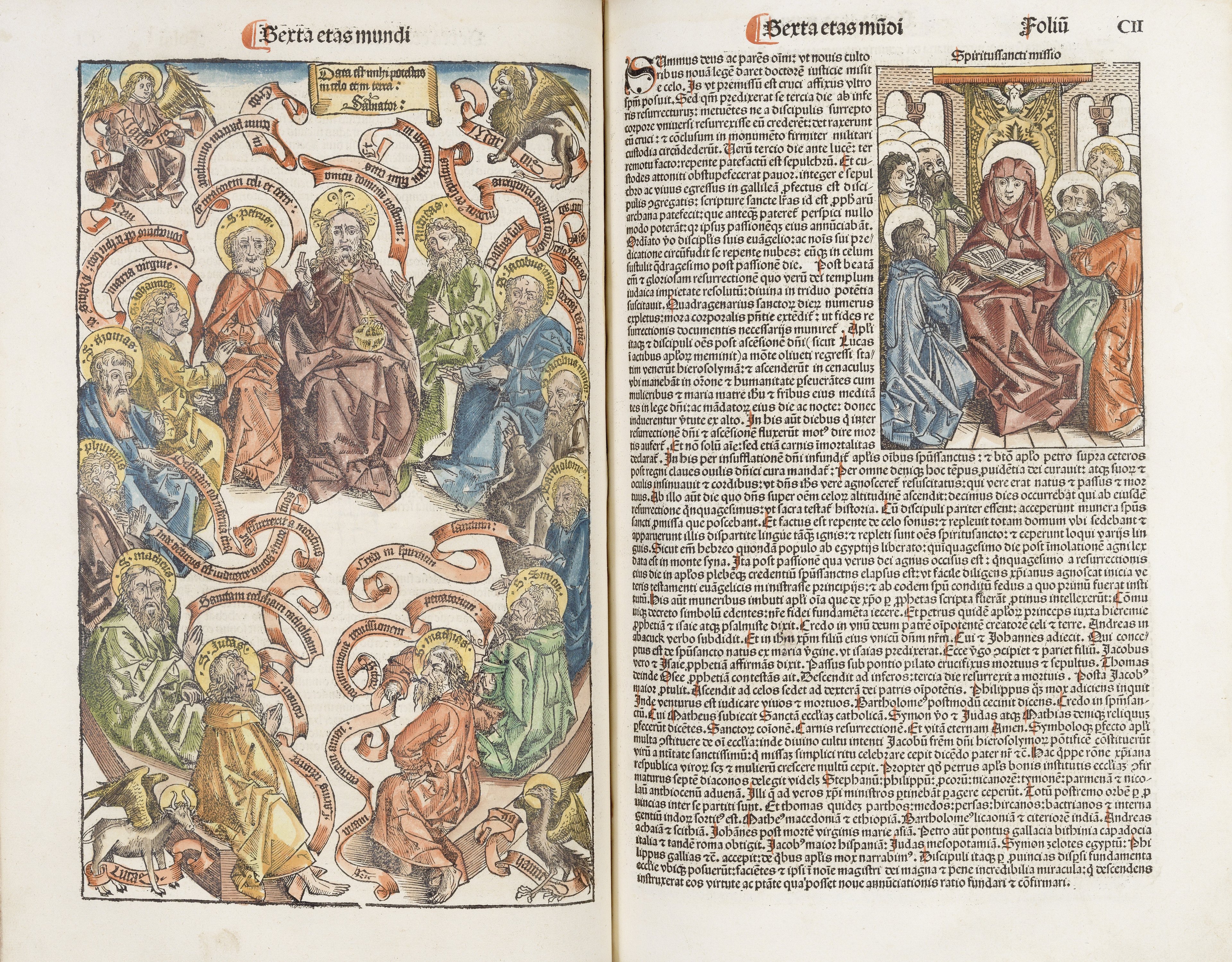
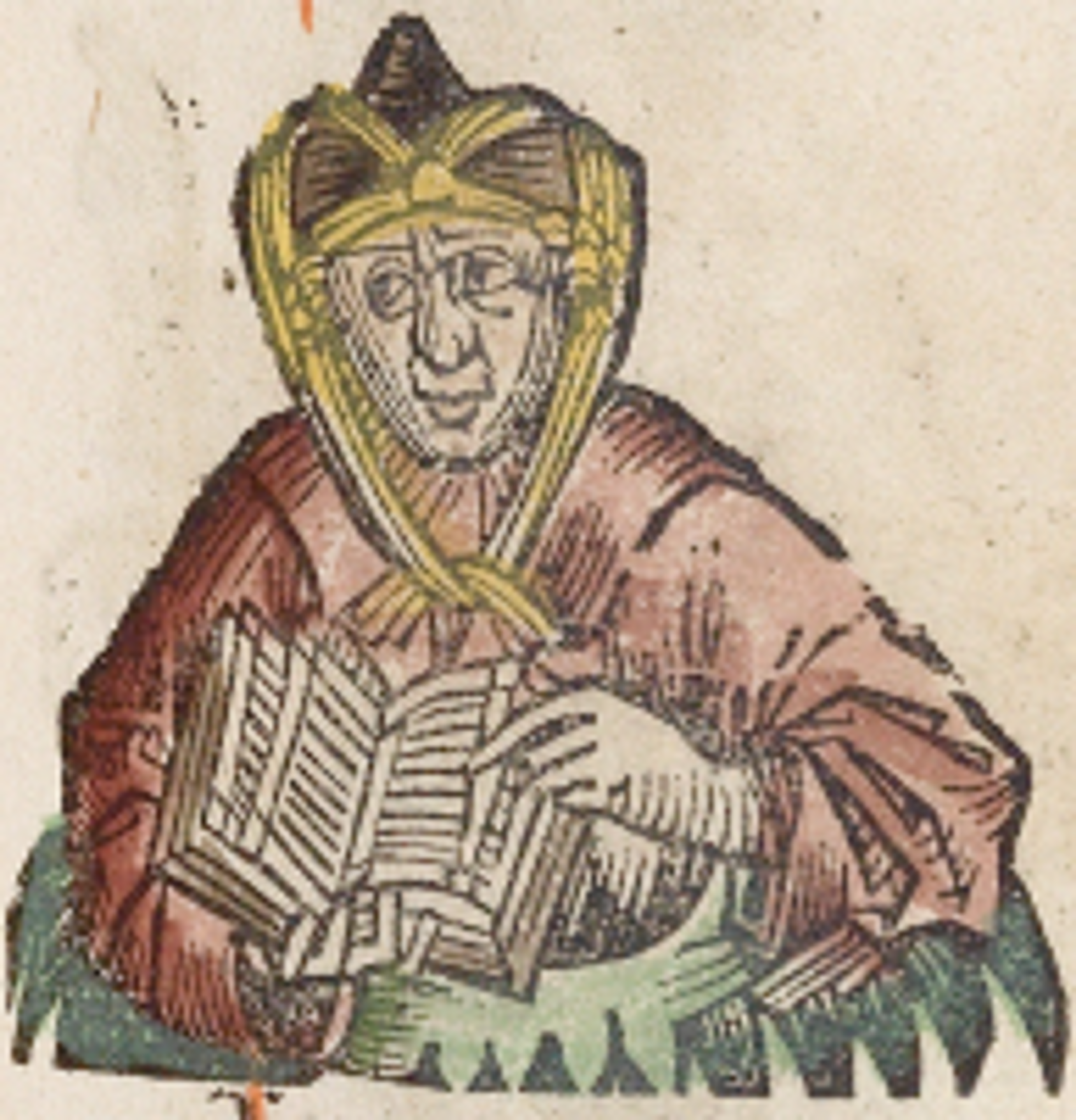
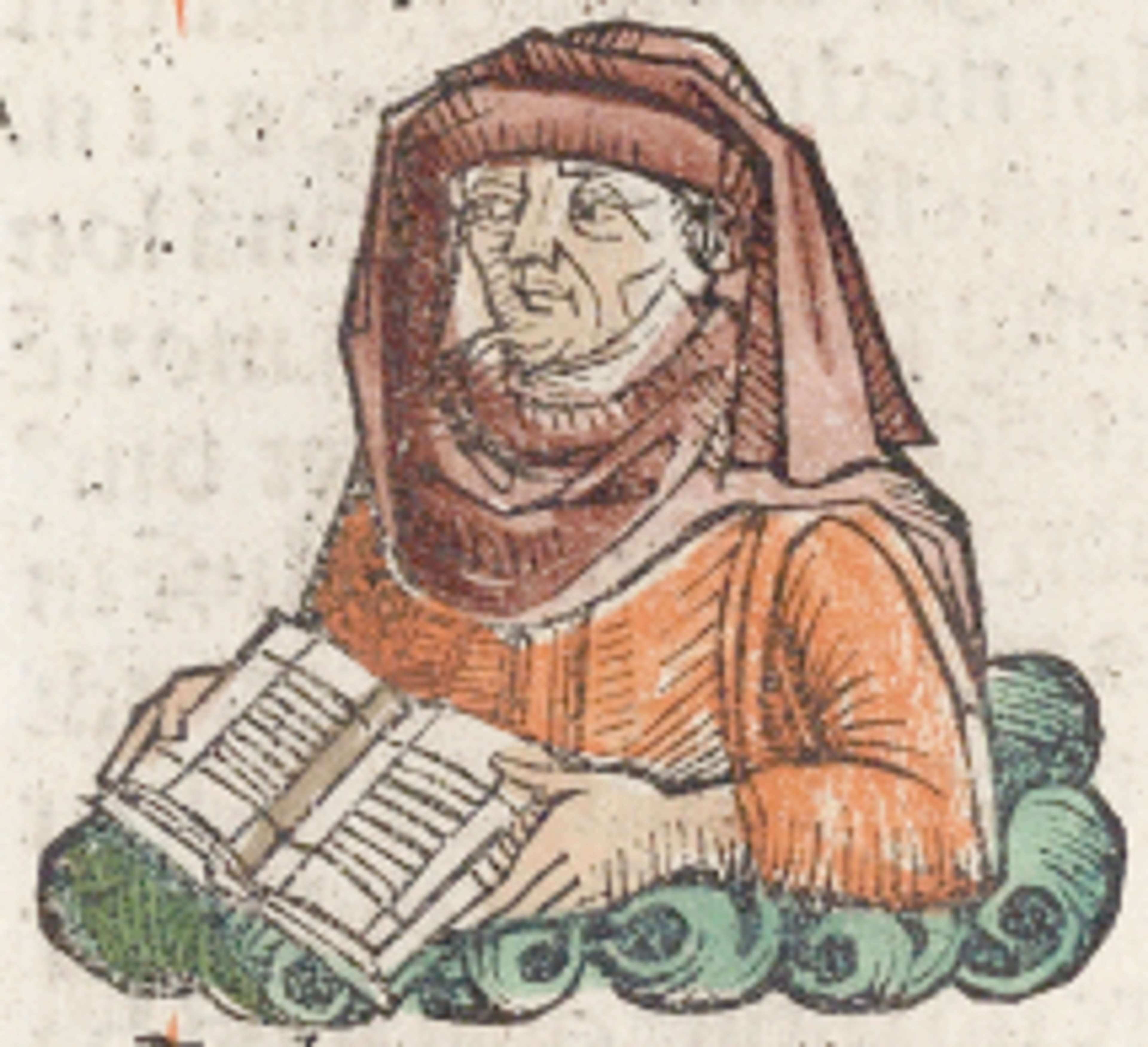
Wilson, Adrian. 1977. The Making of the Nuremberg Chronicle. Amsterdam: Nico Israel.
Woodward, David. 1975. Five Centuries of Map Printing. Chicago: University of Chicago Press.
Wroth, Lawrence. 1944. ‘The Early Cartography of the Pacific’, Papers of the Bibliographical Society of America 38, no. 2: 87–268.
Whitfield, Peter. 1994. The Image of the World: 20 Centuries of World Maps. San Francisco: Pomegranate Artbooks in association with the British Library.